II. SKETCH OF POSITION
OF THE LẠNG SƠN DEPRESSION ON THE REGIONAL STRUCTURE PLAN
Some authors have
been considering that, the Lạng Sơn Depression was developed during
Paleozoic. In fact, it is not completely like that; the anticline directly
related to the formation of the Lạng Sơn Depression belongs to
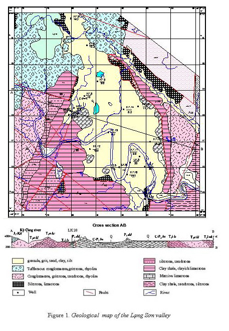
Mesozoic. At present, it is destructed by Mesozoic tectonic movements, its
relics consist of sediments of its two limbs with clear bed attitude presented
on the structural plan (Fig. 1). The results of topographic analysis show that
the Lạng Sơn Depression has a rhombic form, extending in north-south
direction. From Nà Tâm in the north to Nà Tu in the south, its length is about
8 km. From Nà Chang in the west to Pò Luông in the east, its width reaches 4 km
[3]. The whole rhombic depression is the dome of the Mesozoic anticline, the
basement of which is a syncline formed by Paleozoic karstic rocks. The rocks
forming the syncline consist of limestone of the Bắc Sơn and Đồng
Đăng Formations, that is strongly crushed. This structure completely
conforms to the study of Vũ Văn Chinh [13], that is related to the
time of restriction of sedimentary basins situated along the Cao Bằng -
Tiên Yên Fault.
Some geological
literatures consider that the Lạng Sơn spreading depression is a
Quaternary depression occurring in the western corner, formed by two nearly
perpendicular with one another: the Cao Bằng - Tiên Yên and
Along the destructive zone, occur Neogene and Quaternary basins containing loose continental sediments. Destructive zones of faults are composed of fractured and cataclastic zones that are developed in northwest-southeast direction and rather clearly expressed oneself on Landsat and Spot satellite images with the width of, sometimes, over 5 km. The left-lateral movement in the Oligocene-Miocene tectonic phase has been supposed as about from 1000 to 5000 m; the right-lateral movement in the Pliocene-Present tectonic phase - about 500-700 m (based on geomorphologic materials). The Lạng Sơn area was divided into two geological blocks by the Cao Bằng - Tiên Yên Fault, that have different deformation characteristics. The northeast limb of this fault lies in the compression stress field, where are developed closed fissures which have little capacity of containing and transporting groundwater; while the southwest limb, especially the Lạng Sơn City, lies in the spreading stress field, where are developed splitted fissures which are favourable for containing and transporting groundwater.
III. STRUCTURAL
CHARACTERISTICS OF THE LẠNG SƠN DEPRESSION
Since the 90' of the past century, many geological research works have been clarifying the structural nature of the Lạng Sơn Depression, especially its basement structure, and unanimously considering that limestone of the Đồng Đăng Formation (P3 đđ) unconformably covers that of the Bắc Sơn Formation (C-P2 bs), both of them are covered by Quaternary sediments. The works of geological mapping, among them the typical is the project of Survey on urban geology of Lạng Sơn City and our research works carried out since 1993 year, have been allowing the authors of this paper to establish a transversal section of the Lạng Sơn basin for understanding the deep structure of this area, at the same time linking parameters, interpreting the correlation of the basement structure with latent natural hazards.
The rocks
participating in the structure of the Lạng Sơn Depression consist
mainly of Paleozoic karstic formations, distributed in the centre, with
Mesozoic rocks in the two limbs. The Bắc Sơn Formation is composed
of light-grey, thick-bedded to massive limestone, penetrated by calcite veins,
with interbeds of variegated calcareous breccias, 600-700 m thick. The Đồng
Đăng Formation is characterized by black-grey limestone, brecciated
limestone, 150-200 m thick [2]. At present, the structure was broken, faults
are strongly developed, cutting carbonate formations and together with tectonic
movements making the basin subsided. With the above characteristics of the Cao
Bằng - Tiên Yên Fault and its present activities, the basement of the
depression has been divided into many small blocks. In the regional scale, this
area is the contact area between two structuro-facial zones - the Sông Hiến
and An Châu Depressions [9]. The Lạng Sơn Depression was formed by
the pull-apart mechanism, related to the right-lateral slip of the Cao Bằng
- Tiên Yên Fault, with Quaternary sediments deposited in it. The surface of the
depression is rather even, therefore it is still named as Lạng Sơn
basin [3], or Lạng Sơn karstic plain [1]. Carbonate sediments in the
Lạng Sơn Depression were strongly folded and dislocated, forming
series of fold in the influence confines of the melange zone situated along the
fault; just that time was the time point of forming the syncline at the centre
of the Lạng Sơn basin.
The previous study results have been confirming that carbonate sediments of the Bắc Sơn Formation are rather diversified, from limestone, dolomitic limestone, organic limestone, usually grey to light-grey coloured, massive to thick-bedded [6]. The results of drilling for bauxite prospection of the Geological Party No.3 in the Tam Thanh area have been showing that the Quaternary cover is very thin and does not surpass 10 m, and the depth of boreholes does not control the thickness of limestone. The analytic results on limestone quality have been giving that its CaO content is over 50%, showing the purity of limestone, that is favourable for the karstification process.
During the Quaternary,
the Lạng Sơn Depression passed through at least 3 times of uplift
for forming terraces and alluvial banks along the Kỳ Cùng River [4], that
is proved by 3 water traces carved on the limestone cliff situated near the
Khánh Khê Bridge and existing river terraces; surely, there exist at least 3
stages of karstic cave related to 3 times of topographic raising in the Lạng
Sơn area. These karstic cave stages have the relation between one another
both on the surface and in the depth. In general, the Lạng Sơn
Depression has a very thin Quaternary cover, with the greatest thickness not
surpassing 20 m (according to drilling material of the Project of survey on
urban geology of
In the depression, there exist series of subsided pits, that are remains of the lacustrine regime controlling this area in the past. Because of this lacustrine regime, the uppermost horizon of the depression consists of weak soil layer, that is unfavourable condition for construction work. The tectonic forces control also the activity of stream in the Kỳ Cùng River and cause processes of washout and deposition. Our results of survey during the years from 1993 to recent time have been showing that limestone in the city centre exists in two levels: the upper overlies the local base level; the lower is equal or underlies it. Especially, the Kỳ Cùng River flows to the north, crosscutting the Cao Bằng - Tiên Yên Fault at Na Sầm, where the altitude is about 175 m, while in Lạng Sơn City it is of 250 m, it means the difference in altitude between these two areas is 75 m, and the groundwater is able to move from Lạng Sơn to Na Sầm following systems of fissures, among them the most important is the system of opened fissures of the Cao Bằng - Tiên Yên Fault. This is just the latent character in natural hazards of subterranean karstic horizon in Lạng Sơn. At present, in karstic caves of the Tam Thanh and Nhị Thanh touristic districts water flows from the caves to the Kỳ Cùng River in the place of the Lạng Sơn Polyclinic. The Kỳ Cùng River at the city centre corresponds only to its middle course. So, the difference in base level between the city centre and the area, where the river crosscuts the Cao Bằng - Tiên Yên Fault, causes the movement of groundwater along the crushed and fissure zones from the south northwards. This is the cause speeding up the activity of subterranean karst in the Lạng Sơn Depression.
Through many material
sources, it is able to affirm that the
III. LATENT HAZARDS IN
THE
In karstic areas, some natural hazards usually occur, such as: flash flood, mud and rock flow, earth collapse, missing or superfluity of micro-elements (arsenic, iodine, etc.), pollution of water sources, leakage and loss of water in reservoir, subterranean collapse, desertification. As regards the Lạng Sơn Depression, the most worthy hazards are earth collapse, pollution of water sources, subterranean collapse and desertification. In the framework of a paper, we touch upon only the structure of basement rocks of the Lạng Sơn Depression, that consist completely of karstic rocks which are related to the collapse of karstic caves; the oscillation in season of the water level, making the surficial horizon, formed by Quaternary sediments, easy to happen the shrinkage of volume; the Cao Bằng - Tiên Yên Fault with series of fissures and crushed zones of 700-5000 m in width playing the role of drainage channels which speed up the karstification in the depth. A complete karstic system includes two main zones, namely the zone of erosion and corrosion, related to the input factor and the zone of deposition, related to the output factor. Based on this viewpoint, the Lạng Sơn Depression belongs to the erosional zone and is related to the input factor. It is the reason to affirm that the Lạng Sơn Depression is latent in natural hazards.
On the surface of the Lạng Sơn Depression, there are Quaternary sediments, consisting mainly of clay, silty clay, silt mixed with sand and grit-gravel with a thickness not surpassing 20 m, having the sinking coefficient varying from 1.58 to 3.13 kg/cm², among them the largest distributive area belongs to Lower-Middle Holocene clay and loam having the sinking coefficient varying from 1.98 to 2.53 kg/cm². Construction works having the loading capacity surpassing this value make easy to occur the collapse of subterranean karstic caves, especially when the extraction of groundwater reaches the large scale. This is also the area where limestone is exposed directly on the surface of relief in the form of relic peaks or forms steep cliffs in the two banks of the Kỳ Cùng River (in the section where there is army quarter, and the section extending from Tiên Pagoda to Mai Pha Bridge). Karstic caves surely have streams which converge in the Kỳ Cùng River that is observed in area of the Tam Thanh and Nhị Thanh caves, where emitted water flows into the stream running near the Lạng Sơn Polyclinic, then discharges into the Kỳ Cùng River. The areas, where the cave system is strongly developed, are much vulnerable, and latent in such phenomena as collapse of subterranean karst (as in Hà Tây, Phú Thọ, Quảng Trị, etc...). Through our investigation we think that, it is necessary to study in details the rule of karstic distribution during the planning process of construction, because it is a factor causing the loss of stability of the geological environment. Apart from this, the enlargement of groundwater extraction in this area needs a detailed study on the appearance of the above said collapse and a calculation of most rational extracted water quantity, otherwise, there will be great consequences for construction works.
Some previous geological literatures have been touching upon such topographic forms as funnels, pits [3], that are peculiar forms of karst. At present, some of them were filled up for the construction. In the years before 1990, in rice fields there still were remaining limestone mounds rising upon the surface, but at present the urbanization process has been effacing all and residential districts appear with many high buildings, that are developed even upon limestone massifs, as in the Tam Thanh and Nhị Thanh touristic districts. The basement structure of the Lạng Sơn Depression consists of carbonate sediments of great thickness (700-1000 m [12]). The results of analysis of limestone in Lạng Sơn area has been giving: intensity of saturate antipressure is 34-75 kg/cm² [6]. In this area, limestone suffers strong karstification, forming a developed cave system, with crushed and fractured zones, that, combined with the monsoon-tropical climate, are favourable premises for speeding up the development of karstification. During Holocene, karstic pits were filled up with Quaternary deposits, which are loose sediments, easy to be collapsed when the calcareous basement is dissolved and washed out.
In the northeast of the
Lạng Sơn Depression, there is the Cao Bằng - Tiên Yên Fault,
which still is active in present time [8, 11, 12]. Data of the
According to our materials of analyzing maps of topography of different generations, combined with the interpretation of airborne photographs and field survey materials, almost all wells of pressure water is now filled up. The Tiên Well (Angel Well), a touristic site of the Lạng Sơn City, previously is an artesian well, but at present, its water level is lowered about 2-3 m, sometimes deeper, and the water rises only in rainy season.
Nowadays, the
The karstic environment
is characterized by a double spatial system with shortage of surficial water,
but abundance of groundwater, that is vulnerable to all impacts and not
protected by water-sealing beds, therefore the water source is easy to be
polluted by different factors penetrating through caves, crevices, fissures.
And it is very difficult to overcome the consequences caused by pollution. It
is necessary also to rise the consciousness of the community in the protection
of environment. Related to this direction, there is the Vietnamo-Belgian
Project: “Developping the karstic mountainous rural area in Northwest Việt
This paper is completed with the financial support by the Project of Basic Research bearing the code 7.170.06.
REFERENCES
1. Đào Đình
Bắc, 2000. Địa mạo đại cương. Nxb
Đại học Quốc gia Hà Nội, Hà Nội.
2. Đặng Trần
Huyên (Chủ biên), 2006. Báo cáo Địa tầng các
trầm tích Phanerozoi ở Đông Bắc Bộ. LT Viện
KH ĐC&KS, Hà Nội.
3. Đỗ
Hưng Thành, 1995. Sơ lược về lịch sử
hình thành địa hình karst bồn địa Lạng
Sơn. TC Các KHTĐ, 17/3: 134-136. Hà Nội.
4. Lê Cảnh
Tuân, Nguyễn Xuân
5. Ngô Quang Toàn,
2005. Một số hiện tượng nứt đất,
sụt đất có tác động của con người ở
một số nơi trên lãnh thổ Việt
6. Nguyễn
Văn Nghĩa, 2000. Báo cáo Địa chất đô thị
Tp Lạng Sơn. Lưu trữ Địa chất, Hà Nội.
7. Phan Trung Điền,
Ngô Thường San, Phạm Văn Tiềm, 2000. Một
số biến cố địa chất Mesozoi muộn
Kainozoi và hệ thống dầu khí trên thềm lục địa
Việt
8. Tăng
Đình
9. Trần
Văn Trị (Chủ biên), 1977. Địa chất
Việt
10. Vũ Thanh
Tâm, Lê Cảnh Tuân, Phạm Khả Tùy, Đàm Ngọc, Nguyễn
Xuân Nam, Nguyễn Đình Tuấn, Phạm Việt Hà, 2007.
Báo cáo Nghiên cứu, điều tra tai biến địa chất
một số khu vực trọng điểm thuộc vùng
Đông Bắc Bộ phục vụ cho quy hoạch phát triển
kinh tế - xã hội. Lưu trữ Viện KH
ĐC&KS, Hà Nội.
11. Vũ Văn
Chinh, 1996 Một số đứt gãy hoạt động
trong giai đoạn tân kiến tạo vùng Đông Bắc Việt
12. Vũ Văn
Chinh, 2000. Các pha phát triển tân kiến tạo và cơ
chế của đứt gãy Cao Bằng - Tiên Yên. TC Các
KHTĐ, 23/3: 181-187. Hà Nội.