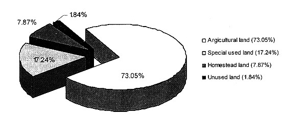
Figure 1. Land use structure of Yên Xá Commune in 2005
[9]
REVIEW OF SOCIO-ECONOMIC SITUATION AND SPATIAL DEVELOPMENT
PLANNING BY LOCAL AUTHORITIES IN YÊN XÁ
COMMUNE, Ý YÊN DISTRICT, NAM ĐỊNH PROVINCE, VIỆT NAM
NGUYỄN
THANH LAN1, NGUYỄN THỊ THU THỦY1,
WILHELM STEINGRUBE2
Abstract: Yên Xá is a small commune lying in the southwest of Nam
Định City with a traditional handicraft village named Tống Xá, which is a pilot
study of the project IWRM-Nam Định. Lying in the Red River Delta, the commune
has the same natural conditions as other provinces in the area with high
temperature, humidity, monsoon, high rainfall and sunshine hours which have
strong impact on agricultural activities. Like many other agricultural
villages, the agricultural land covers the main part in the land use structure;
but the yield of rice and peanut planting is lower than that of other provinces
due to medium quality of soil fertility. However, in the recent years, the
living standard of residential people is increasing. The social characteristics
are also changing with lower percentage of people working in agricultural
sector, which is resulted from industrial development in the commune. With the
attention paid by not only People’s Committee of Yên Xá but also People’s
Committee of the district and province, industrial activities has been
developed in the recent years in all technology, products and customers,
contributing to the economic development of the commune by both sending money
to state budget and providing jobs for people in the area. From that result,
the commune has been oriented to industrialize the traditional handicraft with
agricultural activities.
I. BACKGROUND
Integrated Water Resource
Management (IWRM) is a process which promotes the co-ordinated development and
management of water, land and related resources, in order to maximize the
resultant economic and social welfare in an equitable manner without
compromising the sustainability of vital ecosystems [2]. With regard to the
Dublin Principles from 1992 [2] the “IWRM Nam Định” project on behalf of BMBF
works at the lowest appropriate level in planning and implementation of water
infrastructure. It is the goal to implement waste-water treatment facilities to
clean industrial and domestic sewages in Tống Xá village which is a typical
handicraft village in the
II. INTRODUCTION
Ý Yên is a district of Nam Định Province which is situated 30 km far
from the southwest of
Among 14 communes in Ý Yên District, Yên Xá is a well economically developed
commune because of traditional casting activities. There are two villages in
the commune, named Tống Xá in the north and Cổ Liêu in the south.
III. CHARACTERISTICS OF NATURAL CONDITIONS OF
YÊN XÁ AREA
Yên Xá has the total area of 199.26 ha and boundaries with Yên Bình in
the north, Yên Ninh and Yên Bình in the south, Yên Dương in the east and Yên Khánh
in the west.
In general,
Main stream flows in Yên Xá are Quy Đô River with the length of 1.1 km
and Tống Xá channel lying in the centre of the village. Besides, there are
irrigation systems with the total length of 17 km for agricultural activities [8].
Water for living and producing activities, mainly from surface, ground and rain
water, is plentiful.
IV. CHARACTERISTICS OF LAND USE IN YÊN XÁ
1. Land use status
The total area of Yên Xá Commune is 199.26 ha which is composed of
agricultural land, homestead land, special used land and unused land (Tab. 1).
According to land use structure (Fig. 1), the agricultural land is the biggest
part in Yên Xá (covers 73.05%), which is typical for agricultural villages in
Red River Delta; special used land makes up 17.24%; homestead land is 7.87%;
and the last is unused land with the lowest percentage of 1.84%.
Figure 1. Land use structure of Yên Xá Commune in 2005
[9]
·
Agricultural land includes annual crops land,
miscellaneous garden and water surface land. The main agricultural land is for 2-rice
crops (83.85%) while 1-rice crop land (1.2%) and specified land for farm
production (0.22%) are smaller, making up a very small land use structure in
agriculture. As in other agricultural villages, Yên Xá spends 11.24 ha (7.72%)
of agricultural land for rice seeding. Aquaculture in Yên Xá is not typical in
agriculture activities; there are only some households that have small ponds for
fish rising in household scale. So that, the ponds and lakes land in Yên Xá
makes up only 3.72% (Fig. 2).
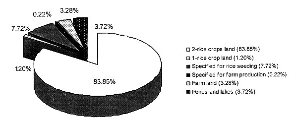
Figure 2. Agricultural
land structure in Yên Xá in 2005 [9]
·
Special used land covers 17.24% which includes construction
land (8.01 ha), transportation land (8.85 ha), irrigation and water surface
land (12.31 ha), historical and cultural sites (0.12 ha), land for construction
materials (0.75 ha), cemetery land (4.05 ha) and other special used land
(0.27ha).
·
·
There are 2 kinds of unused land which covers 3.66 ha
(1.84%): unused flat land (0.23 ha) and unused water surface land (3.43 ha).
Table 1. Land use status of Yên Xá Commune in 2005 [9]
|
|
Total area according to |
Divided by different beneficiaries |
||||
|
Total area |
Household (ha) |
Economic |
Managed by |
Others (ha) |
||
|
Total area |
199.26 |
199.26 |
150.04 |
5.59 |
42.32 |
1.31 |
|
I. Agricultural
land |
145.55 |
145.55 |
134.35 |
|
10.88 |
0.32 |
|
1. Annual crops land |
135.35 |
135.35 |
125.82 |
|
9.44 |
0.09 |
|
2. Miscellaneous garden land |
4.78 |
4.78 |
4.51 |
|
0.07 |
0.20 |
|
3. Water surface land for fishery |
5.45 |
5.45 |
4.02 |
|
1.37 |
0.03 |
|
II. Special used
land |
34.36 |
34.36 |
|
5.59 |
27.78 |
0.99 |
|
1. |
8.01 |
8.01 |
|
5.59 |
1.43 |
0.99 |
|
2. Transportation land |
8.85 |
8.85 |
|
|
8.85 |
|
|
3. Irrigation and water surface land |
12.31 |
12.31 |
|
|
12.31 |
|
|
4. Historical and cultural sites |
0.12 |
0.12 |
|
|
0.12 |
|
|
5. Land for construction materials |
0.75 |
0.75 |
|
|
0.75 |
|
|
6. Cemetery land |
4.05 |
4.05 |
|
|
4.05 |
|
|
7. Other special used land |
0.27 |
0.27 |
|
|
0.27 |
|
|
III. Homestead
land |
15.69 |
15.69 |
15.69 |
|
|
|
|
1. Residential land |
15.69 |
15.69 |
15.69 |
|
|
|
|
IV. Unused land |
3.66 |
3.66 |
|
|
3.66 |
|
|
1. Unused flat land |
0.23 |
0.23 |
|
|
0.23 |
|
|
2. Unused water surface land |
3.43 |
3.43 |
|
|
3.43 |
|
According to data from Yên Xá People’s Committee, agricultural land is
mainly in level H3 and H4 [9] in the land quality rank, which is divided in 6
levels, from H1 to H6 with the fertility of soil decreasing. The area of land
in H3 and H4 level is 121.26 ha, making up 83.31% of the total agricultural
area (Tab. 2). 92.76% of the main land for cultivation, the 2-rice crops land,
(113.21 ha) is in H3 and H4 levels. The area of land with high fertility (in H1
and H2 level) is only 5.18 ha, making up 3.56%. Land with low fertility (in H5
and H6 level), making up 13.13%, is mainly specified for farm production, farm
land, ponds and lakes. This number shows that agricultural
Table 2. Areas of agricultural land
divided by land quality (fertility) rank [9]
|
Types
of land |
Total (ha) |
Divided by land quality (fertility) rank (ha) |
|||||
|
H1 |
H2 |
H3 |
H4 |
H5 |
H6 |
||
|
2-rice crops land |
122.04 |
0.2 |
3.85 |
49.41 |
63.8 |
4.52 |
0.26 |
|
1-rice crop land |
1.75 |
|
|
|
|
0.3 |
1.45 |
|
Specified for rice seeding |
11.24 |
|
1.13 |
4.24 |
3.81 |
2.06 |
|
|
Specified for farm production |
0.32 |
|
|
|
|
|
0.32 |
|
Farm land |
4.78 |
|
|
|
|
|
4.78 |
|
Ponds and lakes |
5.42 |
|
|
|
|
|
5.42 |
|
Total |
145.55 |
0.2 |
4.98 |
53.65 |
67.61 |
6.88 |
12.23 |
|
Percentage |
100% |
0.14 |
3.42 |
36.86 |
46.45 |
4.73 |
8.40 |
2.
Land use change in the period 1995 - 2005
Like many other agricultural villages in the Red
River Delta, Yên Xá follows also the trend of change from agricultural land to
special used land. In 10 years, from 1995 to 2005, the agricultural land has
been reduced 3.36 ha, while special used land has been increased 3.16 ha (Tab.
3). The agricultural land has been changed in using purpose to special used
land mainly to meet the needs of land for construction. During recent years, Yên
Xá has taken an area of about 6 ha (half of it was just established in 2000) to
establish an industrial zone to move all companies there. This shows that the
development orientation of the commune increases the living standard by
industrial activities applied to traditional handicraft.
There is also a small increase in homestead land
(0.2 ha). This is from the area of ponds and lakes that were filled to deliver
to new split households.
Table 3. Land use change in Yên Xá from 1995 to 2005 (unit: ha) [9].
|
Types of land |
1995 |
2005 |
1995-2005 |
|
Agriculture land |
148.91 |
145.55 |
-3.36 |
|
Special used land |
31.2 |
34.36 |
3.16 |
|
|
15.49 |
15.69 |
0.2 |
|
Unused land |
3.66 |
3.66 |
0 |
V. CHARACTERISTICS OF POPULATION OF YÊN XÁ
As recorded in 28 March 2007, the total population
of Yên Xá Commune is 3,442 people with the density of 1727 people/km2,
which is higher than the average of Ý Yên District (1,017 people/km2)
and the whole province (1,197 people/km2). This value has been
increasing from 1,644 people / km2 in 2000 to 1,723 people / km2
in 2006 (Fig. 3).
In 2006, there are 875 households in Yên Xá
Commune with the average people in a household of 3.95 people. The total
population of Tống Xá village is 2,346 people with 551 households, so the
average people in a household is 4.26 people, higher than that of the whole
commune.
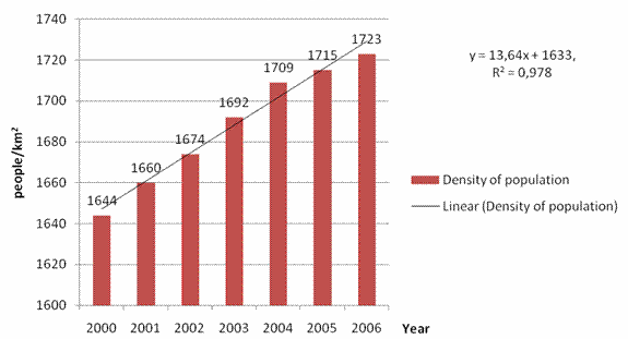
Figure 3. Density of population in
Yên Xá from 2000 to 2006 [11]
The birth rate in Yên Xá changes unstably from
2000 to 2006. It increased suddenly to the highest in 2003 (2.04%) due to
traditional thinking of Vietnamese people that 2003 was a good year to give
birth to children. In 2001 and 2005, the birth rate is the lowest (1.11%). In
other years, it is about 1.5%, changing with small difference (Fig. 4). This
value is higher than the average birth rate of rural area in
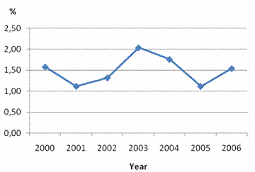
Figure 4. Birth rate in Yên Xá
from 2000 to 2006 [11]
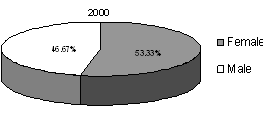
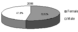
The average percentage of female in Yên Xá is
higher than that of male, approximately 52.5-53.5% in compare to 46.5-47.5% in
the year 2000 (Fig. 5). This is higher than the average of
|
|
|
Figure 5. Ratio of male and female in Yên Xá in 2000
and 2006 [11]
This ratio can be explained by: 1) Number of dead male
people is usually higher than the number of dead female people; 2) Number of
female who get married with male in Yên Xá is higher than the number of female who
leave the village to get married (Tab. 4).
Table 4. Number of birth and death people move in and out of Yên Xá from 2000
to 2006 [11]
|
Year |
Birth (people) |
Death (people) |
People move to Yên Xá |
People move out of Yên Xá |
||||||||
|
Total |
Female |
Male |
Total |
Female |
Male |
Total |
Female |
Male |
Total |
Female |
Male |
|
|
2000 |
52 |
29 |
23 |
18 |
9 |
9 |
15 |
2 |
13 |
18 |
11 |
7 |
|
2001 |
37 |
25 |
12 |
18 |
2 |
16 |
11 |
4 |
7 |
11 |
7 |
4 |
|
2002 |
44 |
19 |
25 |
13 |
4 |
9 |
31 |
16 |
15 |
42 |
28 |
14 |
|
2003 |
69 |
32 |
37 |
17 |
4 |
13 |
17 |
3 |
14 |
27 |
25 |
2 |
|
2004 |
60 |
30 |
30 |
18 |
5 |
13 |
25 |
11 |
14 |
32 |
25 |
7 |
|
2005 |
38 |
18 |
20 |
20 |
10 |
10 |
19 |
5 |
14 |
39 |
18 |
21 |
|
2006 |
53 |
24 |
29 |
19 |
8 |
11 |
14 |
2 |
12 |
43 |
31 |
12 |
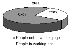
In 2006, the number of people in working age in Yên
Xá Commune is 1,272, in which the number of female is 723 (making up 56.84%)
and the number of male is 549 (43.16%). People in working age make up only
about 27% of the whole population in the commune (Fig. 6). According to the information
from Yên Xá People’s Committee, the percentage of people working in
agricultural sector is about 61.2% and the others are 38.8% [8], mainly working
seasonally for casting and lathing companies.
|
|
|
Figure 6. Percentage of people in
working age in Yên Xá in 2000 and 2006 [11]
VI. CHARACTERISTICS OF LIVING STANDARD OF
RESIDENTAL PEOPLE IN YÊN XÁ
1. Electricity: There are 2 electricity transformer stations in Yên
Xá with total capacity of 1,000 kVA with 11 km in total length of medium and
low tension wire. 100% of the residential area and 100% of households in the
area have access to electricity.
2. Education: In general,
facilities for education in Yên Xá Commune, including schools, teachers are
relatively enough for people’s needs.
Table 5. Education status in Yên Xá Commune [8]
|
|
Teachers |
Pupils |
Class rooms |
|
High
school |
54 |
750 |
16 |
|
Secondary
school |
18 |
279 |
8 |
|
Primary
school |
25 |
513 |
15 |
3. Public health: According to the
report of Centre of Gender, Family and Environment for Development (CGFED)
about sanitation in Ý Yên District, Nam Định Province, average life expectation
of people in Yên Xá Commune is 60, the lowest among all other communes of the
district. About 25% of people in Yên Xá have respiratory problems, because of
environmental pollution from industrial activities.
4. Income: Because of
well-developed industrial activities, income of people working for companies in
2006 is about 1,200,000 VND per month (CGFED), while income of others (not
working for companies) in 2000 is about 5,000,000 VND per person per year. This
fact shows the way for people in Yên Xá to increase their living standard by
developing industrial-oriented handicraft, instead of depending mainly on
agricultural activities.
VII. CHARACTERISTICS OF INDUSTRIAL ACTIVITIES
Industrial activity is the principal economic one of Yên Xá Commune,
especially in Tống Xá. Since some recent years People’s Committee of Nam Định
Province has paid more attention in this commune. In 2000, the second
industrial zone was established in the south of the commune with the total area
of 5 ha which was combined with the first one which is 3 ha. The investment for
it was 7.6 billion VND while state budget was 2.7 billion VND for
infrastructure [1]. At that moment, there are 53 running companies. In 2005 the
Mechanical Casting Association of Ý Yên was founded by People’s Committee of Nam
Định. This association leads casting companies in working and developing as
well as producing.
The area currently covered by the industrial group Tống Xá amounts to 8.9
ha. The current process of expanding in local mechanical casting industry is
resolving the job situation. It is producing income for local inhabitants and
inhabitants of various neighbouring regions. The overall production income of
the small scale industry and construction sector was 20 billion VND (approx. 1
Mio €) in the year 2000 [8]. In 2006, the overall production income of the
small scale industry and construction sector was nearly 200 billion VND, this
amount is higher than 2005 by 25%. By 2006 these companies sent in national
budget approximately 10 billion VND [3].
VIII. CONCLUSIONS
Total area of Yên Xá Commune is 199.26 ha, which
contains agricultural land, homestead land, special used land and unused land,
in which the industrial zone covers 6ha and agricultural land is the biggest in
total of land. Agricultural
In some recent years, People’s Committee of Nam
Định Province has paid attention in industrial activities of traditional
handicraft village and Tống Xá is a village that got special attention from
them. Industrial companies had risen from 23 in 2003 to 53 in 2006. The
increasing number of companies brings about the development of industrial
activities, such as infrastructure, producing process equipment, quality of
production income, as well as the rising awareness of residential people and
companies about environmental protection.
In general, Yên Xá has the socio-geographic
characteristics, that are typical for a traditional Vietnamese handicraft
village. With its potentials, both in natural conditions and human resources, Yên
Xá is following the trend of industrialization, changes to an
industrial-oriented village in order to increase the living standard of people,
but still keeps the characteristics of a traditional handicraft and
agricultural one.
REFERENCES
1.
Đào Huy Quý,
2003. Environmental issues in socio - economic development strategy of
2. GWP, 2000. Integrated Water Resource Management. TAC Background Papers 4.
3.
Hiệp Hội Cơ khí đúc huyện Ý Yên, 2007. Thống kê
doanh thu năm 2006.
4.
Lê Thị Lài,
Nguyễn Thị Hằng, 2003. General characterization of the craft settlements Vân
Chàng, Xuân Tiến and Tống Xá in
5.
Nam Định
statistical office, 2007.
6.
Statistical
office, 2004. Statistical year book. Statistical
Publ. House. Hà Nội.
7.
Trung tâm Nghiên
cứu giới, gia đình và môi trường phát triển (CGFED),
2006. Báo
cáo kết quả nghiên cứu cơ bản điều kiện vệ sinh môi trường tại huyện Ý Yên, tỉnh
Nam Định.
8.
Uỷ ban nhân dân xã Yên
Xá, 2003. Báo cáo quy hoạch sử dụng đất đai xã Yên Xá đến năm 2010.
9.
Uỷ ban nhân dân xã Yên
Xá, 2005. Sơ bộ thuế xã Yên Xá, huyện Ý Yên, tỉnh Nam Định năm 2005.
10.
Uỷ ban nhân dân xã Yên
Xá, 2006. Về thực trạng vệ sinh môi trường cụm công nghiệp làng nghề xã Yên Xá, huyện
Ý Yên.
11.
Uỷ ban nhân dân xã Yên
Xá, 2007. Báo cáo tình hình dân số biến động từ ngày 1 tháng 1 năm 1999 đến tháng 3
năm 2007.