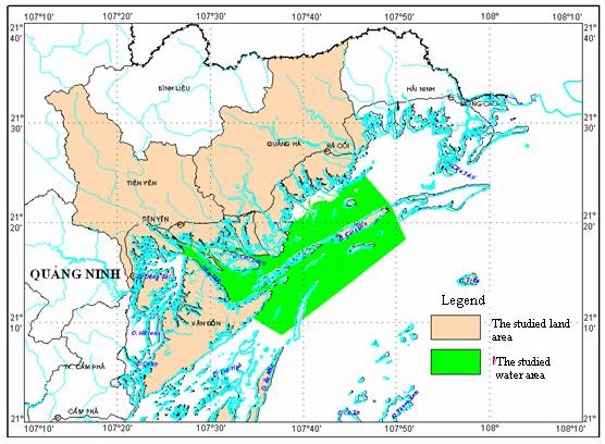
Figure 1. Location of the studied area - the Tiên Yên - Hà Cối Gulf
In order to plan sustainable natural resource
and environment use, many countries in the world have been approaching the
vulnerability assessment of the nature-society system in such areas where
natural resources and environment are being under stress from hazards and human
activities. This paper presents the results of the vulnerability assessment,
which is in first time applied for gulf system of Việt
II. METHODOLOGY OF ASSESSING THE VULNERABILITY OF NATURAL RESOURCES AND ENVIRONMENT
The methodology of assessing the
vulnerability of natural resources and environment applied in this work is
inherited from methods and criteria for assessment of coastal vulnerability
index (CVIs) of America [1, 10], environmental vulnerability index (EVI) of
SOPAC [11], assessment protocol of NOAA [7] with adjustment to the actual
situation of Việt Nam [3, 4, 6, 10]. The assessment criteria are weighed
up according to the Assessment Matrix method of Thomas Saaty [8,
9] based on the Expert
Choice software, then graded and grade-based
ranked (from 1 for the lowest level to 5 for the highest level) for dangers by
the level of risks (or pressures) (i.e. hazards and potential factors causing
or intensifying hazards), density and coping capacity of vulnerable objects.
The protocol of establishing vulnerability map of natural resources and
environment in Tiên Yên - Hà Cối Gulf is presented in Figures 2.
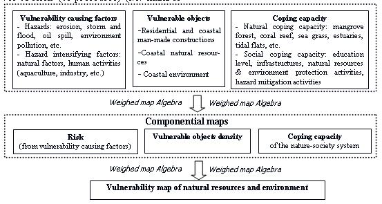
Figure 2. Protocol of establishing the Vulnerability map of natural resources and
environment in the Tiên Yên - Hà Cối Gulf
in GIS.
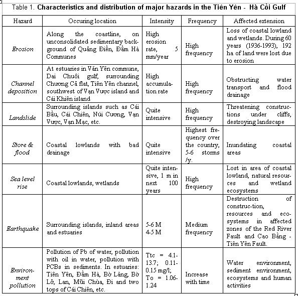
III. CRITERIA OF ASSESSING THE VULNERABILITY OF NATURAL RESOUR-CES AND ENVIRONMENT IN THE TIÊN YÊN - HÀ CỐI GULF
1. Factors causing
vulnerability and the level of risk
The factors causing vulnerability in the Tiên
Yên - Hà Cối Gulf can be determined
as of including 2 main groups: 1) Hazards (erosion,
channel deposition, landslide, storm and flood, earthquake, environment
pollution by heavy metals and organic compounds, etc.) (Table 1); and 2) Factors intensifying hazard, among them natural factors consist of tectonic fault systems, geological background with different cohesion level or different pollutant retent, etc., and man-made factors with human activities,
such as aquaculture, mangrove destroying, agriculture, industry, etc..
Risk from factors causing vulnerability is
assessed on the basis of the nature of hazards, following the formula proposed
by Cutter [1]: G = (F + A) × M (in which, G: total grade of the hazard,
F: hazard frequency and M: hazard intensity) and characteristics of hazard
intensifying factors. These two criteria classes are classified and
interpolated for every 4 km2 of cell in a map by
mathematic algorithms in GIS like classification, ranking, determination of
density and distance, etc. After grading, the processed data are overlapped
based on algebraic weighed mapping methods to create the map of risk at
1:50.000 scale (Fig. 3). The total grade of every cell in the map is the basis
of dividing the studied area into 4 zones with risk from low to high levels as
follows:
a. Zone of low risk: accounting for the greatest area, of 44.9 % of total area of the gulf, including
mainland communes of Đại Đức, Quảng An, Quảng Lâm, Quảng
Sơn, Đại Xuyên and offshore
areas. This zone lies under low impacts of earthquake, flood and
regardless influences from other hazards, whereas human activities are not
intensive.
b. Zone of medium risk: accounting for 35.2 %
of total area of
the gulf, including the inland around upstream of
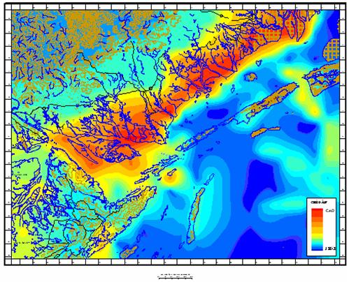
Figure
3. Map of risk in the Tiên Yên - Hà Cối
Gulf
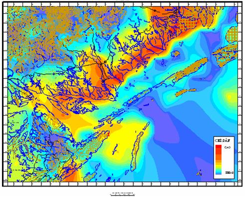
Figure 4. Map of vulnerable object density in the Tiên Yên -
Hà Cối Gulf
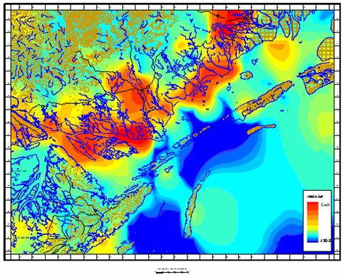
Figure 5. Map of coping capacity in the Tiên Yên - Hà Cối Gulf.
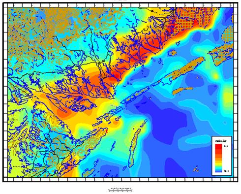
Figure 6. Map
of natural resources and environment vulnerability
of the Tiên Yên - Hà Cối Gulf at
1:50,000 scale.
c. Zone of high risk: accounting
for a small area, of 13.1% of total area of the gulf, including a narrow track
around the zone of medium risk, a narrow track along the coast,
d. Zone of extremely high risk: accounting
for 6.8 % of total area of the gulf, including coastal land and catchment-area of rivers, such
as Đầm Hà, Hà Cối, Ba Chẽ and Tiên Yên ones, towns, such as Hà Cối, Tiên Yên, coastal
communes, such as Quảng Minh, Phú Hải, Quảng Điền, Quảng Phong, Tiến Tới,
Tân Bình, Đại Bình, Đông Hải and the coastal sea of 0-6 m water depth. This is the lowland
under extremely high influence of many hazards (channel deposition, coastal
flood, erosion, environment pollution by oil and heavy metals). This zone has
also high concentration of human activities, especially factories, intrustrial
quarters, mining, aquaculture, fishing, harbours and sea transport.
2. Density of
vulnerable objects
When hazards happen, vulnerable objects in
the Tiên Yên - Hà Cối Gulf can be determined as including residential
areas, infrastructures, natural resources and environment. The major
residential areas include cities,
towns, and coastal villages and
communes, such as Tiên Yên, Đầm Hà, Quảng Hạ ...,
where high population is concentrated. The
infrastructure includes railways, highways, harbours, ports, bridges, dikes,
dams, factories, industrial quarters, Khe Xong hydroelectric factory,
aqua-product processing enterprises, coal mining enterprises, etc.,
schools, hospitals, cultural
constructions and touristic places (Mũi Chùa harbour, Tiên Yên old
streets, Hải Hà economic zone, Quảng Điền
industrial-urban zone), etc..
Natural resources include mineral mines,
landscapes, wetlands, bio-resources and ecosystems. Mineral resources of the
Tiên Yên - Hà Cối Gulf include placer titan-zircon - rare earth mines and
occurrences of ilmenite, zircon, rutile, anatase,
cassiterite, corundum and gold of small reserves.
Wetlands in the Tiên Yên - Hà Cối Gulf
is diverse with 13 coastal types (according to the Wetland
Classification System, proposed by VEPA, 2007), including: permanent shallow
marine water <6 m of depth at low tide (Aa), gulfs and bays (Ab), estuaries
(F), submerged estuarine sandy islets (Fa), estuarine barrier islands (Fb),
rocky marine shores (D), beaches (Ea), intertidal shingle or pebble shores
(Eb), intertidal muddy sand shores (Ga), intertidal sandy mud shores (Gb),
mangrove forests (I), salty/ brackish aquaculture ponds (1a) and sedge farms
(10). Biodiversity is rather high with 754 species and several ecosystems, such
as mangrove forest ecosystem (3,000 ha), sea grass ecosystem (230 ha),
intertidal ecosystem (>18,000 ha), benthos ecosystem (accounts for 2/3 total
area of the gulf).
Similarly to the risk from vulnerability
causing factors, the density of vulnerable objects can be determined based on
features, such as distribution, functions and socio-economic and environmental
values of the objects, which may be influenced by the mentioned hazards and
hazard intensifying factors. Among these objects, the highly graded vulnerable
ones are: human (i.e. population, education level, public health care, etc.),
coastal hazard mitigation constructions (i.e. dike, sea wall, dam, etc.) and
natural resources with high economic values or functions of environmental
protection and hazard mitigation (i.e. geosite, geotope, wetlands, etc.). The
integrated grade in every cell of the map reflects the density of vulnerable
objects in this place. Based on differentiation in the vulnerable object
density map of the studied area, four different zones with distinctive
vulnerable object density can be defined as follows:
a. Zone
of low vulnerable object density: occupying the largest scale in the total area of Tiên Yên -
Hà Cối Gulf (of about 49.3 % of the total area), distributed
around the highland of Đại Đức, Quảng An, Quảng
Lâm, Quảng Sơn, Đại Xuyên communes and on offshore of the
gulf. This zone
is characterized by low density of inhabitants, construction and low economic
values or functions of resources and
ecosystems.
b. Zone of medium vulnerable
object density: occupying about 29.1 % of the total area of the gulf, including
almost all areas surrounding mountains of the Quảng
Long, Động Ngư Communes and highlands of Đại Xuyên,
Văn Yên. This zone is characterized by the medium density of vulnerable objects, medium education level and public
health care and unintensive exploitation of natural resources (i.e.
geosites, wetlands, etc.).
c. Zone of high vulnerable
object density: occupying about 14.5 %, distributed in a narrow band along the catchment-area of Đầm Hà, Hà Cối, Ba Chẽ,
Tiên Yên Rivers and the Cái Bầu, Sầu Đông, Sầu Nam, Chương Ca,
Đá Dừng, Gà Đua, Thạch and Cẩm
Thạch Islands, next to zone of medium
vulnerable object density. This zone has high
potential for development of communication and transport, tourism, mineral
exploitation and aquaculture. The
intellectual
level and infrastructure are quite developed.
d. Zone of extremely high vulnerable object density: occupying small area (about 7.1 % of the total area of the gulf), distributed in cities, towns and catchment areas of rivers (Đầm
Hà, Hà Cối, Ba Chẽ, Tiên Yên). Highly concentrated in this zone are
inhabitants, construction and natural resources of high values and functions.
Wetland resources include several types, such as aquacultural ponds,
estuaries, mangrove forest. Industrial zones,
great harbours and sea ports in this zone have also high significance for
socio-economic development.
3. Coping capacity of the natural resources
and environment
Coping capacity of natural resources and environment of
the Tiên Yên - Hà Cối Gulf
includes objects with natural coping capacity (i.e. mangrove forest,
river systems, estuaries, intertidal flats) or with social coping capacity
(i.e. intellectual level, actions aiming to conserve natural resources and to protect the environment, education and propaganda
aiming to raise the community awareness on hazard mitigation and protection of environment, natural resources and infrastructures,…).
a. Social coping capacity: The main criteria
for assessment of social coping capacity are intellectual
level, management,
administration and actions aiming to conserve the natural resources and to protect the environment and hazard mitigation,
education and propaganda aiming to raise the community awareness (which can be reflected by the number of
schools and teachers, manner of waste gathering, law systems related to the
protection of natural resources and environment, etc.) and infrastructure
(communication and transport system, etc.).
b. Natural coping capacity: The main criteria
for assessment of natural coping capacity include recovering capacity of
renewable resources (i.e. bio-resources,
groundwater, etc.), retention capacity
unrenewable resources (i.e. minerals, oil, gases, etc.), resistance capacity
and maintenance toward functions and natural values of environment (i.e. natural formations, ecosystems, etc.), among these, the mangrove ecosystem is
assessed to have the highest natural coping capacity, thanks to its retention,
ability to mitigate hazards (e.g. erosion, flood and environmental pollution,
etc.), and recovering capacity after influences. Following are intertidal mudflats and consolidated
geological formations. Whereas, unconsolidated formations (for example,
estuaries of Tiên Yên, Ba Chẽ, Đầm Hà, intertidal beaches)
are
assessed as to have the lowest natural coping capacity, due to fragilities
against wave, water current and coastal natural hazards,
sensibility
against erosion and so on.
Based on values and
functions of mitigating vulnerability causing factors and capacity of
conserving natural resources and protecting the environment, the above
determined objects can be graded on coping capacity, interpolated for every 4 km2 cell, and then overlapped by weighed map algebra. By the
establishment of coping capacity map of natural resources and environment in
the Tiên Yên - Hà Cối Gulf at 1:50,000 scale (Fig.
5), five zones can be distinguished according to their coping
capacity:
c. Zone of low coping capacity: occupying 16.9 % of
the total gulf area, distributed in the southeast and northwest of
d. Zone of medium coping capacity: occupying 63.9 % of
the total gulf area, distributed in the east of Sầu Nam island, east of Thoi Xanh island and the highlands of communes, such as Quảng Sơn, Quảng Lâm, Quảng An, Dương Hòa, Đại Đức, Đại Xuyên, Văn Yên, etc.. In these areas,
residences are scattered with low to medium levels
of intellect, education and socio-economic development, whereas the
natural resources, such as geosites, geotopes and wetlands, are not so abundant.
e. Zone of high coping capacity: occupying 10.3 % of
the total gulf area, distributed along a narrow band in the
catchment-areas of the Đầm Hà, Hà Cối, Ba Chẽ and
f. Zone of very high coping capacity: occupying 8.9 % of
the total gulf area, including concentration areas of objects
of high natural coping capacity (i.e. mangrove ecosystem) and social coping
capacity (high intellectual level, developed infrastructure, suitable management and
protection of natural resources and environment), such as catchment-areas of
rivers, cities, towns (Đầm Hà, Hà Cối, Ba Chẽ, Tiên Yên), and communes (Tiên Lãng, Đại Bình, Đầm Hà, Tân
Bình, Quảng Phong, Quảng Điền and Phú Hải).
IV. ASSESSMENT OF VULNERABILITY OF NATURAL RESOURCES AND
ENVI-RONMENT IN THE TIÊN YÊN - HÀ CỐI GULF
The overlap by weighed map algebra (Fig. 2)
of the determined three criteria classes is as follows: 1) Risk
from vulnerability causing factors; 2) Density of vulnerable objects; and 3) Coping capacity of natural resources and environment allowing the
establishment of the vulnerability map of natural resources and environment in the Tiên Yên - Hà Cối Gulf (Fig. 6) at the 1:50,000 scale. In this map, 4
distinctive zones of vulnerability levels from low to high can be distinguished
as follows:
a. Zone of low vulnerability: occupying 51.3 % of
the total gulf area distributed in the offshore and highland areas in the
Đại Dục,
Quảng An, Quảng Lâm, Quảng Sơn communes. These areas suffer
insignificant influence from hazards (earthquake and flood
happening in very low intensity) and stress from socio-economic development, not abundant in natural resources (including
construction materials, agricultural land in small areas and some aquaproducts) and medium coping capacity (without
mangrove ecosystem, medium hazard resistance).
b. Zone
of medium vulnerability: occupying 28% of the total gulf area, distributed next to the zone of low vulnerability and including the offspring areas of the Tiên Yên, Ba Chẽ, and Đầm Hà Rivers (in the Quảng Thanh, Dương Hòa, Dục Yên, Đông Ngư and Tiên Lãng Communes), Đại Xuyên and Văn Yên Communes. These areas have medium risk for vulnerability causing factors
(except for potential of Pb pollution in sea water of some local areas), medium
density of residence and other vulnerable objects, whereas human activities are
mostly agriculture, aquaculture and undeveloped services and trade.
c. Zone of high vulnerability: occupying 13.3 % of the total gulf area, distributed
mainly in the Đồng Ngư, Đồng Lâm, Tiến Tới, Tiên Lãng, Đồng
Rui, Quảng Long, etc. communes
and system of small islands (Tràm, Treo, My, Keo, Đầu Gỗ, Sú Mọt,
etc.). This zone has high residential density, with typical human
activities, such as aquaculture, fishing and ecotourism. The
area of mangrove forest is small, whereas sediments are mainly composed of
sandy mud and muddy sand with medium to high potential of trapping pollutants. Hazards in this zone include landslide, earth crack, channel deposition at
estuaries, bedding erosion (in the Tiên Yên estuary and Đại estuary), Pb pollution of sea water.
d. Zone of extremely high vulnera-bility: occupying 7.3 % of
the total gulf area, including the catchment-areas of the Tiên Yên, Ba Chẽ and Đầm Hà Rivers; the Hà Cối and Tiên Yên Townlets; the Quảng Hạ, Quảng
Trung, Quảng Điền, Quảng Phong, Tiến Tới,
Tân Bình, Đại Bình, etc. coastal communes, and coastal sea from 0-5 to 7 m of water depth. This zone has high residential density with intensive
activities of industry, tourism, aquaculture and procession of aquaproducts,
sea transport and mining. This zone suffers the influences of several hazards,
such as channel deposition (Ba Chẽ estuary, Tiên Yên estuary), erosion (Đầm Hà - Tiên Yên) and flood in coastal lowlands. In addition, the presence
of submarine rock peaks along the Ba Chẽ and
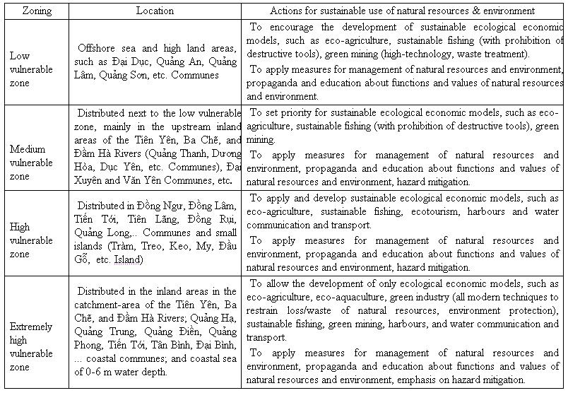
Table 2. Actions for sustainable use of
natural resources and environment in the Tiên Yên - Hà Cối Gulf , based on vulnerability assessment
V. RECOMMENDATION FOR SUSTAI-NABLE USE OF NATURAL RESOURCES AND ENVIRONMENT BASED ON VULNERABILITY ASSESSMENT
The assessment of the vulnerability
of natural resources and environment in the Tiên Yên - Hà Cối Gulf shows that areas of high vulnerability is
generally characterized by combination between high risk (from hazards and
intensifying factors), medium to high density of residence, infrastructure and
natural resources, whereas the coping capacity of socio-economic system is just
medium.
In the contrary, the areas
of low vulnerability not only have low risk from hazards, but also are located
far from social or economic centres, residential zones or position of high
function-value resources. Therefore, the planning for sustainable use of
natural resources and environment should involve in zoning based on
vulnerability. The planning of suitable solutions for mitigation of hazards and
human activities intensifying hazards, redistribution of vulnerable objects and
strengthening coping capacity of socio-economic system should be proposed and
implemented for each corresponding zone. Table 2 shows the
planning solutions proposed for the Tiên Yên - Hà Cối Gulf.
Furthermore, it is necessary
to implement synchronic solution for sustainable use of natural resources and
environment in the Tiên Yên - Hà Cối Gulf, including suggestion of
manage-ment measures (enforcement of laws and policies, community
based management, integrated coastal zone management), mitigation
of coastal hazards (recovery of mangrove area in Đồng
Rui Commune) strengthening constructions protecting the coast (dyke, dams,
water-break, etc.) and resistance against erosion in Mũi Chùa, Vạn Hoa Ports and Tiêu estuary), application
of science and technologies (investment for research and development
of ecological economic models, such as eco-aquaculture, ecotourism, sustainable
mining, green technology, etc., construction of natural
resources and environment monitoring).
VI. CONCLUSIONS
1. The factors determining the
vulnerability of natural resources and environment of the Tiên Yên - Hà Cối
Gulf are vulnerability causing factors (with hazards, such as erosion, channel deposition, storm
and flood, pollution of water and sediments, etc. and hazard intensifying
activities, such as aquaculture, agriculture and
tourism), density of vulnerable objects (i.e.
natural resources, environment, residences and
infrastructure) and coping capacity (including objects with
natural coping capacity, such as mangrove forest, intertidal muddy sand or
sandy mud flats, consolidated geological formations, or with social coping
capacity, such as intellectual level, infrastructure and programs, actions protecting
natural resources and environment, mitigating hazards,
etc.).
2. The Vulnerability Map of natural
resources and environment of the Tiên Yên - Hà Cối Gulf at 1:50,000 scale has been established based on weighed map
algebra with overlapping of three criteria classes: risk
from vulnerability causing factors, density
of vulnerable objects, and coping capacity of natural resources and
environment.
3. Based on vulnerability assessment, the
studied area has been divided into 4 zones with from low to high vulnerability
levels. The zone of high vulnerability is generally under influences of many
hazards and hazard intensifying factors, high density of residences and high
function-value resources, such as mangrove forest, placer minerals, geosites, etc., whereas awareness on risk of hazards,
leading to inadequate management and protection of natural resources and
environment (catchment-areas of the Tiên Yên, Ba Chẽ, and Đầm Hà Rivers; Hà Cối and Tiên Yên Townlets; and Quảng Hạ, Quảng
Trung, Quảng Điền coastal communes, etc.). The
zone of low vulnerability is generally under low risk from hazards, far from
socio-economic and industrial centres, whereas wetlands and bio-resources are
not diverse and abundant (offshore areas and mainland areas in
Đại Dục,
Quảng An, Quảng Lâm and Quảng Sơn Communes).
4. Based on the vulnerability assessment,
solutions for sustainable use of natural resources and environment of the Tiên
Yên - Hà Cối Gulf have been proposed in correspondence to each zone of
low, medium, or high vulnerability different works, such as: planning and
application of socio-economic models (i.e. community based
forestation, ecotourism, eco-aquaculture, sustainable mining, sustainable water communication and
transport, eco-agriculture), hazard mitigation and strengthening the
coping capacity of natural
resources, environ-ment and community (management of natural
resources and environment, education to raise community awareness, environmental
monitoring, etc.).
Acknowledgments: This paper is completed with the support from the
Project of Basic Research under the code 704006.
REFERENCES
1. Cutter S.L., 1996. Vulnerability to environmental hazards. Progress in Human Geog., 20 : 529-539.
2. Lê Thị Thu Hiền,
Mai Trọng Nhuận, Trần Văn Ý, 2006.
Đánh giá tổn thương phục vụ cho quy hoạch
và quản lý môi trường (lấy ví dụ ở Tp Hải
Phòng và phụ cận). TC các Khoa học về
TĐ, 28/1 : 1-10. Hà Nội.
3. Mai Trọng Nhuận,
Nguyễn Thị Hồng Huế, Trần Đăng Quy,
Nguyễn Tài Tuệ, 2005. Đánh giá mức độ dễ bị
tổn thương đới ven biển Phan Thiết - Hồ Tràm, Việt Nam, phục vụ phát triển
bền vững. TC Khoa học Đại học
Quốc gia Hà Nội, 21/4 : 6-16. Hà Nội.
4. Mai Trọng Nhuận (Chủ biên), 2007. Lập
bản đồ địa chất tai biến và dự
báo tai biến vùng biển ven bờ Sóc Trăng (Giai đoạn
1: cửa Định An - cửa Mỹ Thạnh; Giai
đoạn 2: cửa Mỹ Thạnh - Lạc
Hòa), tỷ lệ 1:100.000. Thuộc Đề án “Khảo
sát, đánh giá tiềm năng tài nguyên khoáng sản vùng biển
ven bờ tỉnh Sóc Trăng, tỷ lệ 1:100.000”. Lưu trữ Liên đoàn Địa chất biển. Hà
Nội.
5. Mai Trong Nhuan, Nguyen Thi
Minh Ngoc, Nguyen Tai Tue, Nguyen Thi Hong Hue, Tran Dang Quy, Nguyen Thi Thu
Ha, Pham Bao Ngoc, 2007. Characterization and mitigation of Vietnam coastal hazards for sustainable development. Proc. Japan-Vietnam Symp. on Env. Sci. and Techn. for Sustainable Dev. of coastal and
urban area, Đà Nẵng.
6. Mai Trong Nhuan, Nguyen Thi
Minh Ngoc, Nghiem Quynh Huong, Nguyen Thi Hong Hue, Nguyen Tai Tue, Pham Bao
Ngoc, 2008. Assessment of
7. NOAA, 1999.
Community vulnerability assessment tool CD-ROOM. NOAA Coastal
8. Saaty Th.L., 1980.
The analytic hierarchy process: Planning, priority setting, resource
allocation.
9. Saaty Th.L., 2003.
Decision aiding,decision-making with the AHP: Why is the principal eigenvector
necessary. European J. of Oper. Res., 145
: 85-91.
10. Singh A., Hua Shi, 2003. Assessing human vulnerability in the global coastal zones and developing a coastal vulnerability index (CVI).
11. SOPAC, 1999. Environmental
vulnerability index (EVI) to summarize national environmental vulnerability
profile. http://www.sopac.org.fj/Projects
/Evi/archive.html#documents.