I. GEOGRAPHIC
LOCATION
Nam Định is a province
lying on the Red River Delta. In the northwest, it is bounded by Hà Nam and in the east – by Thái Bình, in the west
– by Ninh Bình and in the south it adjoins the East Sea.
The area of the whole Nam
Định province is 1,636 km2, its population is 2.5 million
people, among which 12.4% are urban dwellers and 87.6 % live in the
countryside.
Land in Nam
Định is relatively even and flat and has the direction of sloping
towards the sea. Its height ranges from 0 to 6 m.
Climate in
Nam
Định is the same as that in the Red River Delta. There are two
seasons in a year: rainy and dry ones. The rainy season lasts from May to
October. The average rainfall in a year is 1824.2 mm. The greatest rainfall (in
the year 1990) is 2067.8 mm. The largest rainfall usually occurs in October
(323-487 mm) and the smallest rainfall, in December (2.3-19.7 mm). The dry
season lasts from November to April of the next year. The rainfall in dry
season is very small, reaching only 10-15% of the total annual rainfall.
II. HYDROGRAPHIC
FEATURES
The stream
network in this area is rather dense. The more it extends to the sea, the more
it is denser. Among the rivers, there are Red, Đáy, Đào, and Ninh
Cơ ones. In the rainy season, the water level in rivers is high, and the
water flow is strong. On the contrary, in the dry season, the water level in
rivers is low, the water flow is gentle. Besides, the water level in rivers depends
on tide.
The unique
features of river in this area are that, the flow is bendy and winding clearly.
It proves that the speed of flow is slow and the slope of river-bed is gentle
and the rivers are rather long. The mentioned above rivers pour a huge water
amount into the sea every year. The average water output of the Red River is 3,800 m3/per day for many years,
the largest output is 37,800 m3/per day and smallest – 440 m3/per
day. Toward the lower river section (toward the sea), the mineralization of
water is higher and higher. The water changes from the form of bicarbonate to
the form of chloride. The Kurlov formula of water of the Red
River is as follows:
In Nam Định:

(Calcium-magnesium bicarbonate)
In
Tân Đệ ferry-boat:

(Sodium-calcium-magnesium
chloride)
According to monitored data, tidal regulations in Nam Định are daily. The
strongest period of tide occurs annually from September to December. The
results of monitoring water level of the sea in Văn Lý Station are shown
in Table 1.
III. POPULATION -
ECONOMY
Population in the area mainly belongs to Kinh people. Population density is
about 800-1000 people/km2. Rice culture is the main way of living in
Nam
Định, besides the handicraft is rather developed. In recent years,
some traditional jobs, such as: decorative plant culture, weaving carpets, arts
and crafts, etc. are being restored and these traditional products are well
accepted by inside and foreign markets.
Traffic
here is very easy. Roads are dense with a network of interprovincial roads,
interdistrict roads and intercommunal roads, etc.. Interprovincial roads
consist of Highways 10, 21, 55 linking Nam Định and Thai Bình,
Ninh Bình and Phủ Lý. Interdistrict roads and intercommunal roads at
present have been improved and upgraded. In addition, there are also railways,
seaway and in the future they will play an important part in connecting sea
area in Nam
Định with nearby areas and abroad.
IV. GEOLOGICAL AND
HYDRO-GEOLOGICAL CHARACTERISTICS
In Nam Định,
aquifers and aquitards lie in the following direction (in descending order):
-
Marine-lacustrine porous mixed sediment aquifer of Holocene age (qh);
- Marine
aquitard sediments of Pleistocene age of Vĩnh Phúc Formation (qp3);
- Porous
sediment aquifer of Pleistocene age of Hà Nội Middle-Upper Subformations
(qp2-3);
- Porous,
porous-bedding sediment aquifer of Miocene - Early Pleistocene age (qp-m2);
The main
characteristics of each hydrogeological unit distributed in the study area are
described as follows (in descending order):
1.
Marine-lacustrine porous mixed sediment aquifer of Holocene age of Thái Bình
Formation (qh)
The Holocene aquifer consists of water-bearing beds of
the Thái Bình and Hải Hưng formations. The Thái Bình Formation is
distributed largely in the Hải Hậu, Nghĩa Hưng, Giao Thủy,
Xuân Trường and Nam Trực districts, Nam Định
Province. It is composed mainly of loams and sand lenses, in some
places with clay layers and multioriginal loam. Groundwater usually exists in
these sand lenses and loam. The thickness of sand lenses is often from 8 to 10
m, in some places up to 12-15 m. Results
obtained from tests in some drill holes show that: water level h = 1-3 m, flow rate q = 0.01-0.5 l/ms, hydraulic
conductivity K = 0.2-1.3 m/day.
The chemical composition and total mineralization
(TDS) change irregularly, depending on soil features, formation features of
water-bearing sand lenses. The water basically is in the form of sodium
chloride.
Main
source supplying water for this aquifer is rain water and surface water. In
some districts, such as Xuân Trường,
Giao Thủy, Hải Hậu and Nghĩa Hưng, there exists
fresh-water lens of small thickness in coastal dunes. The source of fresh-water
in these lenses is rainy water. However, in many places, such as Xuân Trường
and Giao Thủy, this aquifer is invaded by sea-water during the tide rise
and the whole area of this aquifer is semi-salted and as the result, the water
is not usable.
The Hải
Hưng Formation is distributed largely in the areas and is covered by
younger sediments of the Thái Bình Formation. Sediments of different origins
comprise blue-grey clay, silty sand, … The water-bearing sand layer has relatively
stable depth, usually ranging from 12-15 to 22-25 m.
The total
water mineralization of this formation changes irregularly and it exists
fresh-water lens (TDS M <1 g/l). Chemical composition of water is
bicarbonate, bicarbonate-chloride changing gradually into chloride-bicarbonate.
In
general, the water quantity in this formation is not great and the quality is
not good, so the water here is only used for supplying to households in the
river side.
2. Marine aquitard
sediments of Pleistocene age of Vĩnh Phúc Formation (qp3)
Sediments
of the Vĩnh Phúc Formation are largely distributed in the area and are
covered by the Hải Hưng and Thái Bình Formations. They are mainly
composed of clay, silty clay mixed with lateritic gravel. Their thickness
changes from 20 to 25 m. The study results show that average hydraulic conductivity K = 0.05 m/day, maximum Kmax = 0.07
m/day.
3. Porous sediment
aquifer of Pleistocene age of Hà Nội Middle-Upper Subformations (qp2-3)
Sediments
of Pleistocene age of the Hà Nội Formation are largely distributed in the
Red River Delta and are seperated from aquifer of Hải Hưng Formation
by the water registering clay layer of the Vĩnh Phúc Formation. They are
mainly composed of quartz gravel, cobble, and in some places, stones and gravel
mixed with silty sand and silty clay.
Based on
drilling data, it can be seen that the depth of aquifers is relatively stable
and regular.
If looking
at the S-N cross section, or from the sea to the mainland, in the north of the
study area (south of Vụ Bản District), the aquifer lies in the
shadowest direction, 30-35 m in the depth. In the centre of Hải Hậu
District, the aquifer lies in the depth of 80-90 m, in some places up to
hundreds metres or more. Toward the seaside, the aquifer lies in the depth of 60-70
m. The depth of aquifer changes regularly. In the northwest of the area (south
of Ý Yên and Vụ Bản Districts), the depth of aquifer is smallest
(5-10 m). The more the aquifer stretches to the sea, the thicker it is. In some
places, its thickness is 30-50 m. Its average thickness is 28.4 m.
Results obtained from the borehole 109 show that: in
Trực Phú commune, Trực Ninh District, the water level h = 0.25 - 2.5 m, flow rate unit q = 1.5 - 8.89
l/ms, coefficient of transmissibility T = 500 - 1000 m2/day.
Results from analyzed water samples in the wells show
that the total mineralization changes from 0.3 to 3 g/l. The chemical
composition of water is sodium-magnesium bicarbonate or sodium chloride.
In the study areas, a fresh-water lens with large distribution
has been found. It belongs to the Hải Hậu, Nghĩa Hưng, Trực
Ninh and south part of Nam Trực districts. It will be discussed more in
details in the following part.
There are not data that show the hydraulic relationship
between surface water (Red River, Đáy River and Ninh Cơ River) with
groundwater of the Hà Nội Formation.
4. Porous,
porous-bedding sediment aquifer of Miocene - Early Pleistocene age (m2-qp)
This aquifer is composed of sediments of Thái Thụy
Formation and Neogene sediments. They are distributed in the lowest part of
hydrogeological cross section in the study area. This aquifer is not exposed on
the surface, but is covered by Quaternary sediments. It is distributed in the
northeast of the faults F4, F6. In the southwest, it
comes into contact with the Đồng Giao Formation (T2a
đg) through the Fault F6,
in the west, with the Sông Hồng Group (PP sh) through the Faults F8 - F3 - F4.
These
sediments are mainly composed of sand, gravel interbedded with sandstone. The
pressure of this aquifer is strong. The analytic results show that: capacity Q = 1-12 l/s, flow rate unit q = 2-6
l/s, pressure coefficient of transmissibility T = 16-438 m2/day. The chemical composition of water changes
irregularly depending on the depth. In the depth of 250 m in Nghĩa
Hưng District, the water is fresh, but with the same depth in other
districts, it is salted.
V. STATE OF GROUNDWATER EXPLOITATION IN NAM ĐỊNH
PROVINCE
The total quantity of water consumed in Nam Định is about 71,500
m3/day. There are two types of groundwater exploitation: large and
small.
1. Large
exploitation: This form of water exploitation consists of
exploited groundwater in wells with huge capacity in different places. Capacity
is from hundreds to thousands of m3/day. In Nam Định,
some districts use this way of exploitation, such as Hải Hậu, Nghĩa
Hưng, and Ý Yên.
2. Small
exploitation: This form consists of exploiting from drilled and
digged wells in households. It is very popular in rural areas of the country.
In Nam
Định, small drilled wells lie in Pleistocene formations. Some
districts use this way of exploitation, such as: Hải Hậu, Nghĩa
Hưng, Ý Yên and other places; the water is salted.
In
districts and communes of Nam Định Province, there are only two
towns (Cổ Lễ and Ngô Đồng) and three district centres
(Nam Trực, Mỹ Thịnh, and Xuân Trường) setting up a
network of water supply. However, there are few households using this water
supply system.
Besides,
in communes there are other water supply forms as follows:
- A
network of water supply in commutation: capacity of 600-1,800 m3/day.
The water is groundwater or surface water and then it is treated by filtering
and decontaminating, and then pumping to houses.
- A
network of water supply from drilled wells. This network helps to upgrade the
effectiveness of UNICEF drilled wells and to limit the number of drilled wells
unused and to restrict groundwater pollution. Centre of living water and rural
environment has set up a network of water supply in places, such as Đoài
Village, Yên Bảng Commune; Hải Thịnh commune, Hải Hậu
District; hospital in Mỹ Lộc District.
This network of water supply was set up since 1984. According to
surveyed data up to now there are 76,238 drilled wells with the depth of from
15-25 to 90-130 m in the whole province. State of supplying water in the
country is shown in Table 2.
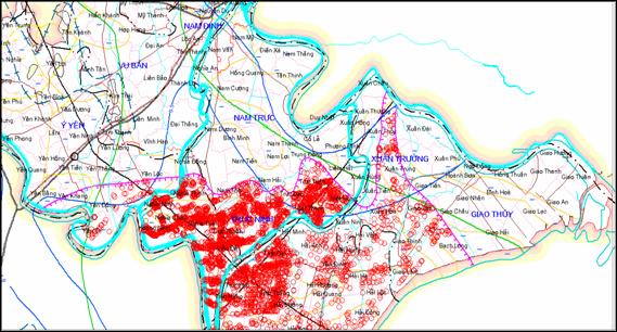
The orange
colour (As: 0.025-0.05 mg/l) appears in a map in a spotted form and appears in
all surveyed districts.
The yellow
colour (As: 0.01-0.025 mg/l) appears largely in the map and largest stretching
from Trực Ninh to Nghĩa Hưng. Besides, it appears in spotted
form in many places.
The blue
colour (As <0,01 mg/l) shows places are safe for As. This colour appears in
the spotted alternate form, but occurs largely in south Hải Hậu
(Fig. 2).
It can say
that groundwater in Nam
Định has high As content. When using groundwater, it is necessary to
treat it to ensure the quality for living water and good health.
Table 4. As
content in grounwater in Nam
Định
|
Samples No.
|
Samples under 0.01 mg/l
|
Samples from 0.01 to 0.025 mg/l
|
Samples from 0.025 to 0.05 mg/l
|
Samples from 0.05 mg/l above
|
|
17,320
|
11,249
|
4,802
|
286
|
983
|
The study on As origin shows that As lies
in clay-mud sediments containing organic matter. When the water chemistry
changes, As moves from sediments into water under a complex mechanism.
VII. CONCLUSIONS
1. Among aquifers in Nam Định Province, the
Pleistocene Aquifer plays an important role in water supply, but it is polluted
by As. When exploiting for use, it is necessary to treat water.
2. Porous aquifer, porous-bedding sediments
of Late Miocene - Early Pleistocene age (m2-qp1) has not been carefully studied so they
have not been having an evaluation on As pollution.
3. Origin and
movement of As in groundwater in Nam Định have not been carefully
studied, so they need to be continued to be studied in the coming time, aiming
to supply with safe water to local people.
REFERENCES
1. Bùi Học (Editor),
2005. Evaluating the stability of exploiting and using groundwater in Việt
Nam. Strategic orientation of exploiting and protecting groundwater resource
until 2020. Hà Nội University of
Mining and Geology (in Vietnamese).
2.
Dept of Water Management, 2008. Report on surveyed results
of As pollution reality in natural groundwater and water in wells in households
– Part 1. Hà Nội.
3.
Đỗ Văn Bình, 2006. Formation and
distribution of As in groundwater in Quaternary in Hà Nội. Evaluation,
forecast and sollution to minimize bad effects of As on water for living. Ph.D thesis, Hà Nội Univ. of Mining
and Geology (in Vietnamese).
4. Nguyễn Tuấn Anh (Editor), 1998-2001. Investigating on status of
exploiting groundwater, and quantity, quality of groundwater in Red River and Cửu
Long Deltas, and in some important places in Hà Nội and Hồ Chí Minh
Cities. Inst. of Water Resources, Hà Nội
(in Vietnamese).
5. Nguyễn Văn Đản, 2000. Hydrogeologic general features of seidments in deltas in Việt Nam
and problems of water suply. Intern.
Conf. on As pollution – Reality and its effect on health and protective
sollutions. Hà Nội.