Figure 1. Water quality of the
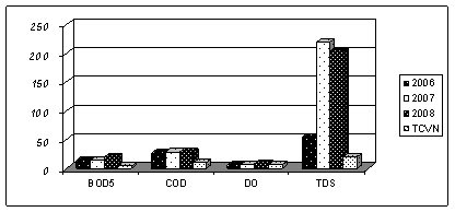
Figure 2. Water
quality of the
Figure
3. Water quality of the
PREWORKS
FOR A FUTURE IWRM - MONITORING OF WATER RESOURCES IN
LÊ THỊ LÀI1, J. KASBOHM2,
NGUYỄN ĐỨC RỠI1,
ĐOÀN VĂN CANH3,
ĐỖ VĂN BÌNH3
1Institute of Geological Sciences;
3Hà
Abstract: In the
time period from 2002-2004 and 2006-2008, more than 1000 measurements of water
quality were carried out on the following parameters: COD, BOD, NH4,
NO2, NO3, TDS and selected
heavy metals.
The
results clearly revealed that the groundwater of the Holocene aquifer in most
investigated locations is highly contaminated by iron, with a high content of
salinity. Also, water from the Pleistocene aquifer shows a higher concentration
of ammonia; the water is free from NH4 only in a small area along
the coastal line from Nghia Hung to Hai Hau. The salinity in water of the Pleistocene
aquifer is also a serious problem, especially in the northeastern part of the
province. The degree of water level in the coastal area is observed. This downward
trend may reflect an unsustainable extraction regime of the groundwater.
A
monitoring plan for groundwater level and salinity trends is recommended in
addition to the existing national observation wells.
The surface
water resource, such as water from Red River, Day River and Ninh Co River and
from lakes and ponds in the Nam Định City is impaired mostly by TDS,
COD, BOD5, and pathogens (coliforms) compared to TCVN 5842- 1995 A. A
river water quality monitoring plan for characterizing the water quality using
diatoms is recommended as a biological method.
I. INTRODUCTION
The IWRM-MoST-Nam Định project is
a part of the Research Project IWRM-Vietnam. It is a
collaboration between the
Pre-investigations to get basic data for designing a water quality monitoring program are the frameworks of the IWRM-Nam Định-MoST Project.
In order to identify the elements, which may impair the water sources, surface water as well as groundwater, in the time period of 2002-2004 and 2006-2008, more than 1000 water samples were analyzed chemically and biologically. Additional data about water levels are collected from national monitoring wells.
This paper presents the results of the water quality assessment. Based
on this data, a concept for water quality monitoring program for
II.
OVERVIEW OF WATER RESOURCE
IN
1. Surface water
As
Table 1. Average water discharge from the Red and Đào Rivers
|
River and observed location |
August( Qmax m3/s) |
February(Qmin m3/s) |
|
|
3,800 |
450 |
|
|
2,010 |
260 |
2. Groundwater
The Red River
Delta is one of 6 important hydrogeological regions in Việt
Table 2. Hydrogeological character of
water-bearing formations in the
|
Age |
Formation |
Thickness (m) |
Lithology |
Water table |
Discharge (l/s) |
Water type |
|
Holocene |
Thái
Bình |
2-28 |
Sand,
silty clay, clay containing fauna and plant remains |
0.5-3 |
0.05-1.45 |
Na-Mg-HCO3-Cl |
|
Hải
Hưng |
1.3-27.5 |
Fine
sand, silty sand, silty clay, interbedded with sand lenses |
0.5-3.4 |
0.5-
5 |
Na-HCO3-Cl |
|
|
Pleistocene |
Hà
Nội |
10-50 |
Quartz
sand, grit and pebbles containing polymictic pebbles |
0-2.5 |
>
5 |
Na-HCO3-Cl |
|
Pliocene |
Vĩnh
Bảo |
35-85 |
Fine and medium sandstone containing pebbles,
siltstone and clay shale |
0.6-1.2 |
<
12 |
|
|
Triassic |
Đồng
Giao (T2a đg) |
100 |
Gray and dark gray massive and thick-bedded
limestone |
0.2 |
5.78 |
Na-Ca-HCO3-Cl |
The most significant of the hydrogeological situation in this area is the
existence of fresh-water lens within the Pleistocene aquifer located in the coastal region. This lens
occupies the whole area of Hải Hậu, Nghĩa Hưng Districts,
the southern part of Nam Trực, Trực Ninh and some parts of Xuân Trường, Giao Thủy Districts. The water of
this lens is of very good quality and is a precious resource for drinking water
supply.
III. WATER QUALITY AND RISKS OF WATER QUALITY
1. Surface water
quality
Surface water is an essential element in the social life and different
economic sectors of
Compared
the results of 300 surface water sample
analyses and the Vietnamese Standard for surface water as supply source for
drinking water (TCVN 5842-1995 A), we
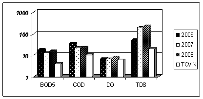
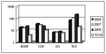
have identified that water from Red, Đáy and Ninh Cơ Rivers is
impaired mostly by TDS, COD, BOD5, and pathogens (coliform). In
Figures 1, 2 and 3, the water quality of the Red, Đào and
Figure 1. Water quality of the
Figure 2. Water
quality of the
Figure
3. Water quality of the
2. Groundwater
quality
The Holocene aquifer
(qh) is in contact with the surface without a confining layer. So it has a
direct relationship with the surface and stays under interaction with human
activities. Therefore the water in this aquifer may be affected through
different pathways from the surface. Results from our
investigation from 2002-2008 (Tab.3)
show that the groundwater of the Holocene aquifer in Nam Định is widely
contaminated by
The top 6 pollutants (COD, BOD5, NO2, NO3, NH4 and Fe) are responsible for over 30% (COD) 45% (BOD5), 60% (NH4) and 75% (Fe) of analyzed water samples.
Up to now, an effective waste water treatment system exists neither in craft settlements nor in the industrial zones. Untreated waste water flows directly into the nature. In addition, because of a very high population density in the craft settlements, many ponds were filled up with waste to make place for production. These are some of the main pathways for pollution in this shallow groundwater source.
Table 3. Average content of
some environmental parameters in water of Holocene and Pleistocene aquifers in
|
Value |
Parameter (mg/l) |
||||||
|
BOD5 |
COD |
pH |
NO2 |
NO3 |
NH4 |
Fe |
|
|
Holocene aquifer |
|||||||
|
Max |
24.0 |
78.6 |
8.03 |
13.5 |
12.4 |
176.4 |
26.3 |
|
Min |
2.6 |
5.1 |
6.55 |
0.01 |
<0.1 |
0.01 |
0.02 |
|
Mean |
9.0 |
26.5 |
7.11 |
1.4 |
1.2 |
51.3 |
6.18 |
|
Pleistocene aquifer |
|||||||
|
Max |
114.0 |
174.0 |
8.0 |
12.8 |
9.5 |
75.7 |
- |
|
Min |
0.6 |
2.4 |
6.55 |
0.01 |
0.01 |
0.01 |
- |
|
Mean |
9.3 |
24.6 |
7.0 |
1.14 |
0.75 |
8.65 |
- |
|
VN-Standards
TCVN 1995* |
<4 |
10 |
6.5-8.0 |
0.1 |
10.0 |
|
5.0 |
|
WHO** |
|
|
|
0.1 |
10.0 |
|
0.30 |
* Vietnamese
guideline for groundwater
**
World Health Organization Guideline for drinking water
The Pleistocene aquifer, covered by a confining layer (qh vp), is only in
contact with the surface and upper aquifers via “hydrogeological windows”, e.g.,
regions near the
The pollution infiltration at a confined aquifer in areas with thick confining cover is small, since the water compression level in this aquifer is always higher than in the upper ones. The intensive water exploitation, however, has a strong effect on the water level decrease, which may creates the vertical gradient speeding up of the convection for pollution infiltration. In our four studied seasons, at some points, the western area of Nghĩa Hưng District has the ammonium concentration increasing significantly with time. This area is also the place where the groundwater in the Pleistocene aquifer was the most intensively exploited in the last ten years. This inappropriate water exploitation can be targeted as the reason for the ammonium pollution in groundwater in this aquifer [3].
Considering the sedimentary cross section in the east-west direction from Vụ Bản through Nghĩa Hưng to Hải Hậu [3], the sedimentary thickness of confining cover near Vụ Bản is very thin with the value of only 10 to 25 m, while near Hải Hậu it increases from 30 to 80 m. This is clearly the reason for the organic compound and ammonium pollutions in Holocene and Pleistocene aquifers in the northeastern and northern parts of the province.
At the moment, the Pleistocene aquifer along the seashore of Hải Hậu and Nghĩa Hưng districts is still in good quality: free of ammonium and other nitrogenous compounds. It serves as the water supply for over 90 percent of residents in the coastal region. Most of the residents in this area get the drinking water from individual private water wells (called as UNICEF wells).
However, in terms of biochemical oxygen and chemical oxygen demand, the water in this area has already been in the early stage of pollution.
IV.
IWRM-MONITORING PLAN
The goal of an
IWRM-monitoring plan in
The objective of such
plan is to identify and document the conditions of
1. Surface water
quality monitoring by using diatom as bio-indicator
Because of its sensible reaction on the environmental change, diatoms
are used for the characterization of the biological surface water quality in
Europe since beginning of 20th Century, to estimate the trophic
state, saproby system as well as other characteristic parameters like
temperature, oxygen content or pH value of lentic or flowing water bodies. In
frame of the IWRM-Nam Định Project, an investigation of surface
water quality in some water course of the
As an
example, saproby
indices of diatoms from the water samples of
Therefore diatoms are
recommended for the surface water quality monitoring, especially for the river
water bodies in
2. Salinity monitoring
Our groundwater
quality studies from 2002 to 2004 and from 2006 to 2008 show that the problem
of high concentration of iron, ammonia, and salinity in groundwater in both the
Holocene and Pleistocene aquifer is a serious issue for
Our goal in developing a groundwater quality
monitoring program is to answer the question: what are the seasonal and
long-term trends in groundwater quality especially the variation of the
salinity? How is the boundary of fresh water and brackish water shifted? How could mirrored in future any water
management activities in frame of IWRM-processes in the groundwater resources?
Is a recharge of groundwater
by methods of rain harvest or using of in future treated waste
water also a possible option to improve the groundwater resources and its
quality?
As in the
A national monitoring wells system always exists in
1. Arranging the monitoring wells perpendicularly to the fresh and brackish water boundary. This boundary is determined on the basis of geophysical data (measured by resistance method or sampling to analyze water quality). These monitoring wells are arranged perpendicularly to the brackish/fresh water boundary. The wells are arranged in straight lines.
2. For the observation of groundwater dynamics, the dynamics of surface
water (river water) must also be taken into consideration, therefore a station
for monitoring the
Following works have to be implemented in the coming time:
1. The degraded wells from the national observation well system (with
broken concrete bases, unclear information table, vandalized geodesic marks,
stolen protective lids and tubes on borehole ...) need to be repaired and
maintained.
2. Adding 7 monitoring wells to the area of Ý Yên,
3. Geophysical resistance measurement of the wells must be carried out twice a year, in May and in November.
4. Sampling and analyzing water samples from observation wells twice a year, in May and in November.
5. Well data documentation and analysis.
V.
CONCLUSION
The problem on the trends of groundwater quality, especially the variation
of the salinity and the movement of fresh/brackish water boundary, is a large
task for
Acknowledgements: The authors would like to thank the Federal Ministry for Education and Research ( BMBF) and the Ministry of Science and Technology of Việt Nam for the financial and logistical support (41/2007-NDT).We would like to express our special thanks to the authorities and colleagues of DOST and DONRE of Nam Định and Yên Xá People Committee.
REFERENCES
1. Đào Huy Quý, Lê Đức Ngân, Đào Mạnh
Tường, 2005. Water problem in
the strategy for socio-economic development of
2. Đoàn Văn Cánh, Lê Thị Lài, Hoàng Văn
Hưng, Nguyễn Đức Rỡi, Nguyễn Văn
Nghĩa, 2005: Groundwater resources of
3. Lê Thi Lài. 2007. Groundwater
investigation: Approach tool for the integration water resource management in
4. Pavlik N., Kasbohm J., Dang
Diem Hong, Le Thi Lai, 2007. Categorization of biological
water quality using diatoms on example of
5. Rott E., Hofmann G., Pall K., Pfister P., Pipp E., 1997.
Indikationslisten fuer Aufwuchsalgen, Teil 1: Saprobielle Indikation. Bundesminsterium fuer Land- und
Forstwirtschaft, Wasserwirtschaftskataster