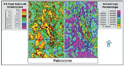
Figure 1. Paleocene fracture zone (in oval) analyzed from Vs-fast and S-wave
percentage maps having E-W trend (70-90o) and NW-SE (110-130o)
(after [10]).
4C SEISMIC
TECHNICS: A FEASIBILITY STUDY FOR FRACTURE ZONE INSIDE THE GRANITE-BASEMENT
RESERVOIR IN THE
HOÀNG VIỆT BÁCH
Domestic Exploration Department,
PetroVietnam Exploration-Production Corporation (PVEP)
Abstract: Almost current oil and gas reserves in Việt
Eivind
et al. [1] pointed out that “4C seismic method” has been known as a new
geophysical technic with latest seismic equipment, such as the I-O’s
I. INTRODUCTION
During the Late Oligocene to Early Miocene, an
inversion occurred in the
The above mentioned challenge requires to find
out a significant technics to map the fracture inside the granite-basement
structure. The 4C seismic technic is aimed to fill the weekness and develop the
strength of Ocean Bottom Cable (OBC) methods [1]. In this new geophysical
method, 4C seismic data including S-wave data are received by the I-O’s
VectorSeis Ocean (VSO) cable. The data is processed and interpreted to analyze
the fracture properties (i.e. fracture trend, fracture density, etc.) inside
the granite-basement highs. Based on that, the model of fractured-basement
reservoir will be study in more detail and accurately to constrain the
petroleum exploration and production, and fractured-reservoir management.
II. S-WAVE, A FEASIBILITY DISCRIMINATION OF FRACTURE/PORE FILLING FLUIDS
Normally, the S-wave velocity (Vs) is about a
half of P-wave one (Vp). That relationship varies with different lithologic
characteristics, so it is used to characterize the lithology [8]. However,
unlikely the P-wave, the S-wave is sensitive with fracture/pore filling fluids
because it can not prograde in the fluid environment [8]. In fact, S-wave has
been also proved that it is more sensitive than P-wave in the
petroleum-reservoir description. The Vs response is much better than Vp one for
the same petroleum-reservoir interval, and top and base of the reservoir is
therefore highlightened by the Vs data.
Therefore, S-wave velocity and density is very
useful in petroleum exploration, because it can be used to describe fracture
and/or pore rock filling fluids. In the anisotropic medium, such as fractured
zone, the values of S-wave velocity vary with prograding trends [9]. The fast
velocity (Vs-fast) is measured when S-wave prograding in parallel with fracture
trend, and the slow velocity (Vs-slow) is measured when the wave prograding in
perpendicular with trend of fracture. Based on that, the fracture trend and
density can be analyzed from the Vs-fast and Vs-slow attribute-maps.
1. 4C seismic method
4C seismic technic is one of the OBC methods
developed in recent years with the ocean bottom cable that is consistent with
the too shallow, too deep and/or the obstructed areas, where the conventional
reflection method could not be carried out. This 4C method uses the ocean
bottom cable, I-O’s VectorSeis Ocean (VSO) including four components sensors:
one hydrophone, one vertical geophone and two horizontal geophones (one is
parallel with the VSO cable and the other is normal with the cable) [1].
Seismically, Possion’s ratio can be calculated from the 4C seismic data.
Therefore, the lithology and liquid saturation should be estimated from the
Poisson’s Ratio since that is impossible with the conventional 2D/3D data [1].
In addition, the fracture properties should be studied by 4C seismic data since
S-wave has a feasibility discrimination of fracture filling fluids.
Having the latest equipment, the 4C seismic
method therefore has higher cost than that of the conventional reflection
methods. The 4C method is normally applied for prospects and/or field areas
where they were discovered by other geophysical methods. This new geophysical
technic can be used to study more in detail the structures and also save money
in the petroleum exploration and production. The method is summarized as below
[6].
2. 4C seimic vessel
Based on the size of the survey, one or more
seismic vessels can be used. Single 4C seismic vessel is normally used in a
small to medium survey, while two or more vessels may be used for a bigger
survey.
Ocean Pearl is a typical example of 4C seismic
vessels. With 108 m in length, the vessel has been equipped to handle 12×6000 m
VSO cables and dual source arrays with volumes in excess of 4000 cu. in. With a
heli-deck and 200 days endurance this vessel has been designed and rigged to
provide the highest quality 4C data worldwide with unprecedented operational
efficiency.
3. C-wave Source Design
In response to increasing demand for orthogonal
geometry (cross-spread) surveys, where radial symmetry of source output is
required, omni-directional sources, such at that illustrated below, can be
designed to meet specific client requirements.
Figure 1. Paleocene fracture zone (in oval) analyzed from Vs-fast and S-wave
percentage maps having E-W trend (70-90o) and NW-SE (110-130o)
(after [10]).
4. Cable and source deployment
Ocean bottom cable deployment and recovery is
accomplished hands-free using a combination of linear engines and winches.
Coupling the superior station keeping capabilities of the M/v Bourbon’s Dynamic
Positioning-2 system with the winch/linear engine control systems ensures that
the VSO cables are deployed and recovered safely, rapidly and accurately at all
times.
5. Cable/Sensors
The VSO system utilises solid-state
accelerometer sensors whose performance has been extensively proven onshore. The
6. Recording buoy
Each 6000 m cable is connected to a
radio-controlled remote recording buoy. Data recording to dual Raid discs in
each buoy is controlled and QC’d using a long range 900 MHz radio system,
whilst geophysical QC is accomplished using a broader bandwidth 2.4 GHz link.
7. 4C seismic data.
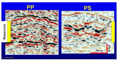
Figure 2. 4C seismic data (PS) in the right hand side showing clearly different
top of reservoir with that of the P-wave data from the conventional reflected
seismic method in Alba field,

Figure 3. Fracture
zone along the major NW-SE trending fault analyzed from the Vs-fast and Percent
S-wave anisotropy maps (after Gaiser and Vandok, 2003).
III. FEASIBILITY
APPLICATION OF THE 4C SEISMIC TECHNIC FOR STUDYING FRACTURE ZONE INSIDE THE
GRANITE-BASEMENT RESERVOIR IN THE
The feasibility study of the 4C seismic method
for the fracture properties was discussed above, and it may be concluded that
it is suitable to apply in the study on the fracture zone containing oil and
gas. We need to analyze whether this method can point out fracture trend and
density in the granite basement reservoir in Việt
Most of petroleum reserves in Việt
Since an application of new geophysical
technics is needed for fracture study inside the granite-basement reservoirs;
the 4C seismic method may be a good choice. The 4C seismic data will be
processed and interpreted to map the imaging of fractures and/or minor faults
inside the granite structures. Therefore, the model of fractured
granite-basement reservoir can be studied more detail and accurately. That may
reduce risks in petroleum exploration and production and also gives aids in the
fractured-reservoir management.
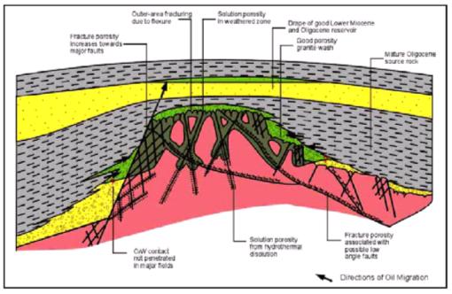
Figure
4.
Model of the fractured granite basement reservoir in the
(after [5]).
IV. CONCLUSIONS
The study on S-wave is still not well
considered in the petroleum exploration and production in Việt
The 4c seismic method is a new geophysical
technic with latest equipment. It can be operated in the obstructed area, in
the two shallow- and too deep-water environment where the conventional
reflection seismic methods could not be carried out. The 4C seismic technic is
used to study petroleum reservoirs by measuring 4C data including S-wave using
the VSO cable with four sensors components.
Almost petroleum reserves of Việt
REFERENCES
1. Eivind et al., 2007. Seismic multi-component technical [available
online], http://www.pgs.com/Geophysical_Services/Marine/Technical_Library/Acquisition/Acquisition_of_Multi-component/
2. Gaiser J.E., Vandock
R.R., 2003. PS-wave azimuthal
anisotropy: Benefits for fracture reservoir management. Proc. of the AAPG Intern. Conf.,
3. Hanson R., MacLeod
M., Bell C., Riel P.V., 1999.
4C seismic data and reservoir modeling at Alba Field.
4. Jin S., Cambois G.,
Vuillermoz C., 2000. Shear-wave velocity
and density estimation from PS-wave AVO analysis: Application to an OBS dataset
from the
5. N.Đ. Hưng, L.V. Hùng,
2003. Petroleum geology of
6. RXT, 2007. Technology [online available], http://www.rxt.com/about/technology.htm
7. Sheriff T., 2006. Seismology and magnetics. Geology, 437.
8.
9. Thompson C., 2006. Expert answers. CSEG RECORDER, March 2006.
10. Vetri L., Gaiser J.,
Loinger E., Lynn H., 2003. 3D/4C Emilio: A
multi-component survey for fracture characterization. Proc. of the AAPG Intern. Conf.,