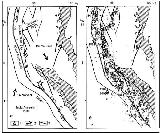
Figure 1. Tectonic map (а) and distribution of earthquake focuses on the
of
TSUNAMOGENIC EARTHQUAKE OF 26.12.2004, NORTH
SUMATRA
V.
STAROSTENKO, A. KENDZERA,
Abstract: Consideration of the problem of tsunamogenic
earthquakes is linked with three aspects: 1) Problem of tsunami emersion; 2)
Problem of the mantle block structure under the region of the investigation
(used the method of Taylor's approximation for
solution of seismic tomography problem for constructing 3-D P-velocity mantle
structure of the Southeast Asia up to the depth 2600 km); 3) Question of
advancing extended Rayleigh wave (captured wave) in the interblock medium.
According to the seismic tomography model, one can see that the strong (М≥7)
tsunamogenic earthquakes connected with the sinking of high-velocity layer and
the mantle velocity separation zones, which create conditions for formation of
both secondary
I. INTRODUCTION
Earthquake is
a consequence of emersion of aperture of earth material continuity (rock
failure) or shifting of one edge against the other along existing fault in the
earth interior. Fault in the geological environment is spread with the speed of
several kilometres per second, and its boards at that radiate elastic waves,
which reach Earth’s surface and make it move with everything on it.
Earthquake
focuses are distributed on the Earth nonuniformly. Overwhelming majority of
earthquakes emerges in proximity to the areas of juncture of tectonic plates
composing Earth's crust – hard shell of our planet, thus forming the so-called
seismic belts: Pacific, Mediterranean-Transasian, Pamir-Baikalian,
Mid-Atlantic, etc.. The most active among those is the Pacific belt.
Consideration of the
problem of tsunamogenic earthquakes is linked with three aspects: 1) Problem of
tsunami emersion; 2) Problem of the mantle block structure under the region of
the investigation; 3) Question of advancing of extended Rayleigh wave (captured
wave) in the interblock medium.
For consideration of the
first question, we use the result of T. Ohmachi et al. (2001). This work
emphasizes significant influence of both acoustical effect and dynamic
displacement of the sea floor on the height of tsunami wave and time of its
arrival as a result of rupture of seismic disturbances (fault, shift fault,
hade fault) at strong earthquakes (М≥7).
The second problem is
solved in the context of 3-D P-velocity model of mantle of
The third question is
linked with the series of papers of Dubrovsky V.A. (the last paper by Dubrovsky
V.A., Sergeev V.N. [2]), in which the theory of wave propagation along the
faults is explained. For us fundamental point among the results obtained by the
authors will be the fact that in conditions of rather sharp edges between the
blocks (in our case mantle blocks) generalized Rayleigh wave emerges. We will
not discuss problems of advancing of generalized Rayleigh waves referring those
interested to the authors of the mentioned work. We will only mention that
according to [2] the dicussed wave is the one running along the fault dividing
two elastic half-spaces with a friction coefficient depending on the velocity
and shift. Rayleigh wave propagates along the fault, its amplitude
exponentially dies out at its recession from the surface of fault between two
abutting elastic half-spaces, i.e. on the one hand, fault is a guide for a
running wave, and, on the other hand, it facilitates conversion of energy of
body seismic waves into the energy of a running wave. Therefore, the term
“captured wave” is introduced. It refers to the wave carrying captured energy
of body seismic waves falling on the fault.
Propagation of the captured
wave along the crack leads to instability of the fault itself and formation of
new cracks. Thus we get a situation of item 1. Therefore, our task is to study
inclined high-velocity layers, mantle velocity blocks under the region in
question, to analyze zones of the division in the mantle under the region
studied, and to correlate hypocenters and mantle division zones.
II. SEISMOTECTONIC SETTING
Catastrophic
Sumatra-Andaman earthquake of 2004 (Mw = 9.3) happened on the flank
of Sunda seismic region (Fig. 1а) bending
Andaman and
On the part of Sunda arc
above the equator the oceanic plate has a very flat angle of subduction under
the subcontinental plate (about 9-11°) [11]. Along the trench axis earthquake
focuses preceding Sumatra-Andaman earthquake (see Fig. 1b) lie mostly in the
earth’s crust of the ocean plate. Active seismogenic structures of continental
crust are pull-apart ruptural structures of back-arc basin and two largest
right-shift faults: Andaman-Nicobar and Central Sumatran faults, drawing of
which in the point of their junction given in the different papers may vary.
Fig. 1а shows a variant of scheme of fractural structure from the work by [5],
where these faults do not join the common structure.
Figure 1. Tectonic map (а) and distribution of earthquake focuses on the
of
Sumatra-Andaman earthquake
of 26.12.2004 is the most tragic in its consequences over the whole historical
observation period. Tsunami wave produced by it took about 300 thousand human
lives. During 10 months after that earthquake there were about 4.5 thousand of
aftershocks. Band of their concentration is shown in Fig. 2. Forty of them had
magnitudes (Мв and Ms) about 6, which is comparable with
the number of analogous events for the observation period 1973 to 2004. In the
aftershock sequence three intense aftershocks are distinguished: two of them
with magnitudes Мх ~ 7.5 (the first one in 3 h 23 min. after the
main shock, and the second one 24.07.2005) took place to the west of Nicobar
Islands, and the one with Mw = 8.7 (28.03.2005) - to the north of
Nias.
Seismic data set analyses
show that fault having begun to rip open at the depth about 30 km was spreading
to the Earth’s surface in the north-northwest direction [1]. Aftershock
sequence of the first three months before the strong aftershock with Mw
= 8.7 allows to define the focus of the earthquakes, which corresponds to the
fault with about 1250 km stretch located mostly to the north-northeast from the
point of emission of the main seismic pulse (see Fig. 1b, big star). Following
the aftershock of 28.03.2005 the segment to the south from the point of
beginning of rip opening main shock fault with the spread about 500 km became
active (see Fig. 2).
Mechanism of focus of
Sumatra-Andaman earthquake, which has been defined by the seismic center of
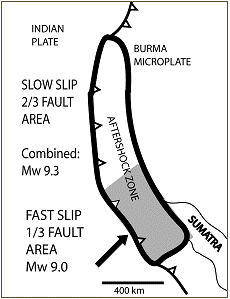
Figure 2. Zone
of the aftershock sequence of the earthquake of 26.12.2004 near the northern
end of
III. MANTLE VELOCITY STRUCTURE OF THE TERRITORY
UNDER
Papers by N.T. Puspito et
al. [9], Widiyantoro S. & Van der Hilst R. [14, 15], E. Hafkenscheid et al.
[4], etc. were dedicated to velocity structures of mantle in this region. The
basis of our work is the method of
Data on the first arrival
of Р-waves in the stations of the international seismological network for the
period from 1964 to 2004 published in the reports of the International
Seismological Centre (ISC) have been used as basic data. Earthquakes satisfying
the following conditions have been chosen: 1) magnitude ≥4.5; 2) focal depth ≤50
km; 3) number of stations having registered the earthquake ≥300. Description of
the used system of observations and applied procedure is represented in the
paper by [16].
3-D Р-velocity structure of
the mantle under North Sumatra and its surroundings is represented in a form of
horizontal cross-sections in actual velocities in 25 km and vertical
cross-sections to the depth of 2600 km through 1° in residuals in relation to
one-dimensional reference model obtained as a result of seismic tomography
analysis for our 3-D P-velocity mantle model for Eurasia. Hypocenters of
earthquakes in the area under study for a period from 1973 to 2007 with
magnitude М≥5 in a depth interval of ±12.5 km to the cross-section set point
have been included in the horizontal cross-sections according to the data of
USGS/NEIC database [7].
Horizontal cross-sections (Fig. 3). Two areas are distinguished on the 50 km
horizontal cross-section: high velocity area (V ≥7.93 km/s) corresponding to
Indo-Australia plate (HIAP), and low velocity one (HEAP) representing Eurasian
plate. In the area of НЕАР subareas are distinguished: HAND, which corresponds
to the massif of Sino-Burma within the studied region (minimum V = 7.825 km/s
in the Sino-Burma area, HSU1, which corresponds to the region of Mentawai island-arc system and
North Sumatra (minimum V = 7.725 km/s in the area of
Velocity collision is
distinguished on the 75 km horizontal cross-section in the area under
The attention is drawn to
the development of triple junction in the subduction area. On the horizontal
cross-section 75 km area of НAND outspreads in the south-western direction to
the northern end of Sumatra occupying the territory under southern part of
The second element,
low-velocity area НSU1, moves in the eastern direction with the depth
corresponding to the eastern part of HSU area. Area HSU1 spreads to
Area HSU being a background
one for the region in question is characterized by low velocity up to 100 km
depth. At the depths of 125 km and 175 km zone of rather high velocities is
observed on the general low-velocity background of Sunda shelf under
northwestern part of Sunda shelf near northeastern coast of
Thus, one may note, that
according to the horizontal cross-sections, earthquake of 26.12.2004 in the
region of North Sumatra (3.30° N and 95.78° E) leading to disastrous tsunami is
associated with the area of triple juncture of Indo-Australia plate and
structures of Eurasian plate - Sunda shelf and deep-water basin of Andaman Sea
(structures of Indochina block). Earthquake hypocenters in the region under
study correlate at the depth with the separated area of triple junction.
Vertical cross-sections (Fig. 4). In the paper by [16] the mantle blocks
were distinguished in the mantle of
On the cross-sections
subduction of Indo-Australia plate under the
In this work, the term
velocity “division zone” in the mantle refers to the boundary between two
velocity mantle blocks, each having its own velocity characteristics.
It is seen on the
latitudinal cross-sections, that projection to the depth of hypocenters of
tsunamogenic earthquakes is mostly connected with mantle velocity division
zones present in all layers of mantle under these earthquakes: beginning from
the upper part of lower upper mantle and to the upper mantle. It may be
expected that availability of such division zones all the way down in the
mantle and availability of sinking plate activates captured waves corresponding
to the mentioned mantle division zones. Outcome of the latter to the surface
leads to strengthening of existing seismic disturbances, which according to T.
Ohmachi et al. (2001) causes delay of tsunami wave arrival and influences
weakly the wave height. On the other hand, according to [2], release of energy
of a captured wave accumulating energy of body waves spreading in the
neighboring blocks may cause strong earthquakes. Fig. 5 shows velocity division
zones of upper mantle, as well as middle and lower mantle of the region on the
100 km horizontal cross-section. Hypocenters of historical tsunamogenic
earthquakes on this figure [13], as well as hypocenter of Sumatra-Andaman earthquake of 26.12.2004 and its
aftershocks of the first 24 hours correlate with mantle velocity separation
zones.
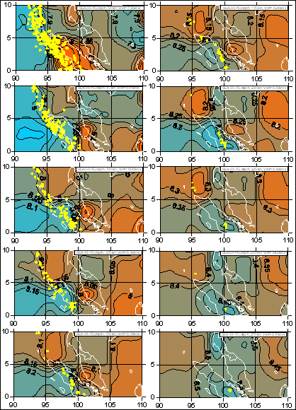
Figure 3.
Horizontal cross-sections of 3-D P-velocity model of mantle to the depth of 275
km of the
IV. CONCLUSIONS
It follows from correlation
of mantle velocity structure of the region in question with tectonic structure,
that possible causes of earthquakes generating tsunami is combination of the
following factors:
1. Complex tectonic pattern
of the region of North Sumatra is complicated by availability of oblique
subduction, Central Sumatra right-shift fault,
transform fault of
2. Availability of the area of triple juncture of Indo-Australia plate and
structures of Eurasian plate - Sunda shelf and depression of Andaman Sea - in
the upper mantle shows itself also in velocity structure of the upper mantle;
3. Confinedness of strong (М³7) tsunamogenic
earthquakes both to sinking high-velocity layer and to the distinguished mantle
velocity separation zones (see Fig. 5) creates conditions for formation of both
secondary
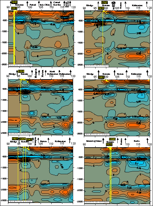
Figure 4.
Latitudinal cross-sections 3-D P-velocity model of the mantle of the territory
under study up to the 2600 km depth with projecting to the depth of historical
tsunamogenic sources [13].
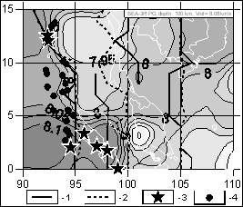
Figure 5. 100 km horizontal cross-section. References: 1- division zones of
upper mantle;
2- division zones of middle mantle,
division zones-II and lower mantle division zones;
3- hypocenters of historical tsunamogenic earthquakes in this territory; 4-
hypocenters
of aftershocks of Sumatra-Andaman earthquake of
26.12.2004.
REFERENCES
1. Ammon C.J., Ji C, Thio H.-K. et al., 2005.
Rupture process of the 2004 Sumatra-Andaman Earthquake. Science,
308: 1133-1139.
2.
Dubrovsky V.A, Sergeev V.N., 2006. Short- and intermediate-term harbingers of earthquakes as
display of instability of sliding along breaks. Physics of the Earth, 10: 11-18.
3.
Geyko V.S., 2004.
A general theory of the seismic travel-time tomography. Geophys. J., 26/1: 3-32.
4.
Hafkenscheid E., S.J.H. Buiter, M.J.R. Wortel, W. Spakman, H. Bijwaard, 2001. Modelling the seismic velocity
structure beneath
5.
Khain V.E., Lomize M.G., 1995. Geotectonics with geodynamics bases. Mosk. Univ. Publ. House, Мoscow, 480 p.
6.
7.
NEIC, 2007. http://neic.usgs.gov/neis/epic/epic_rect.html.
8.
Prawirodirdjo L.M., 2002. A geodetic study of Sumatra and
9.
Puspito N.T., Yamanaka Y., Miyatake T., Shimazaki K. & Hirahara K., 1993. Three-D P-wave velocity structure
beneath the Indonesian region. Tectonophysics,
220: 175-192.
10.
Rebetsky J.L., Marinin A.V., 2006. A field of pressure of Sumatra-Andaman earthquakes
26.12.2004: Model of a metastable condition of rocks. Geol. & Geoph., 47/11: 1192-1206.
11.
Rivera L., Shea K., Helmberger D., Natawidjaja D., 2002. A comparative study of the
12.
Tatsuo Ohmachi, Hirashi Tsukiyama, Hiroyuki Matsumoto, 2001. Simulation of tsunami introduced
by dynamic displaycement of seabed due to seismic faulting. Bull. Seism. Soc. Am., 91/6: 1898-1909.
13.
Tsunami Laboratory, 2007. Historical tsunamogenic sources in the
14.
Widiyantoro S. & van der Hilst R., 1996. Structure and evolution of lithospheric slab
beneath the Sunda arc,
15.
Widiyantoro S. & van der Hilst, R., 1997. Mantle structure beneath
16.
Zaiets L.N., T.A. Tsvetkova, I.V. Bugaienko,