BOUNDARY
REGION BETWEEN THE SOUTH CHINESE PLATFORM AND THE PHILIPPINES OCEANIC PLATE
(Three-dimensional P-velocity model)
2PODGORNYJ V., 3GILMANOVA
G., 1TSVETKOVA Т., 1BUGAIENKO I.
1Institute of Geophysics of S.I. Subbotin, UAS Ukraina, Kiev, Ukraina;
2Institute of Tectonics and Geophysics of J.F. Kosygina, FED the
RAS, Khabarovsk, Russia;
3Pacific Oceanologic Institute of V.I. Ilyichev, FED the RAS,
Vladivostok, Russia
Abstract: The method of Taylor's approximation for solution of
seismic tomography problem used by us to construct 3-D P-velocity mantle
structure of the boundary region between the South Chinese platform and the
Philippines oceanic plate up to the depth 2500 km. 3-D P-velocity model of the mantle under Taiwan
region corresponds to a zone of convergence of continental and oceanic plates.
Luzon-Taiwan-Ryukyu-Okinawa island-arc tectonic region finds its reflection in
seismic velocity characteristics in mantle as boundary zone between continental
and ocean plates. For Luzon-Taiwan part this structure shows for all depth of
mantle, and in the part Ryukyu-Okinawa only in the upper mantle.
I.GEOLOGO-GEOPHYSICAL PERFORMANCE OF A BOUNDARY REGION BETWEEN SOUTH CHINA PLATFORM AND PHILIPPINES
OCEANIC PLATE
The Luzon-Taiwan-Rjukju system, as boundary part
between southeast continental borderland of Asia and northwest borderland of the
oceanic plate of Philippines
Sea estimed in the limits
of 15-35oN and 117-127oE. This territory contains the
northern end of the Luzon arc, the Taiwan
Island and the southwest
end of Ryukuy island-arc system. The Philippines
Sea is presented by the West
Philippines basin, a continental part - Southeast China and wide shelf of South
China and East China Seas.
Heterogeneous structure of the continental
borderland of SE Asia is result of an intensive extension it, which is
connected with the formation of the South China and East China seas and others oceanic basins in Cenozoic.
They were closed and dipped into the east zones of subductions in late
Cenozoic. The west of northern borderland of Luzon island-arc is surrounding by
deep-water basin of the South China Sea. This
basin rests on oceanic lithosphere, which dipped in east direction along the
Manila trough under the plate of Philippines
Sea. Volcanic activity of
the Luzon arc is related to this dipping. The
oceanic plate of Philippines Sea dipped under the continental shelf of the East China Sea along Ryukuy trough. Okinawa back-arc
basin locates to the north from the Luzon arc,
which one the extension and modern volcanic activity is linked. The Taiwan Island
has arisen on continental borderland because of a collision of a northwest
angle of an oceanic plate with the continental lithosphere.
The oceanic crust of the West
Philippines basin is of Eocene age. It is supposed, that the Luzon
arc which is setting from the west by the Manila
trough, existed since early Miocene. It is most likely that activity has
stopped in the Quaternary period. The most northern peak of modern volcanic
activity of the arc is Batan Islands (nearby
21.2°N).
The South China Sea
was opened in Oligocene-Miocene time (32-15 Ma). The subduction of lithosphere
of the South China Sea was since early Miocene along the Manila trough under
the Philippines Sea plate. To the north, with approach
to Taiwan Island,
there is a consecutive transferring from subduction of oceanic crust of the sea
to a collision continent-ocean and to underthrust of southeast continental
borderland of China
under island.
Active area of Taiwan
Island generated because of dynamic interaction
of a northwest angle of an oceanic plate of Philippines Sea
and borderland of the Asian continent, to the southeast from elongated in a
north-northeast direction structures of China Continent.
The Ryukuy trough, fore-arc ridge Jaema, intra-arc
basin Nanao and Ryukyu island-arc extended to the east from northern part of Taiwan Island.
They are structural elements characterized by a zone of subduction of a
northwest part of the Philippines
plate under Asian, along the Ryukyu trough. The interaction area between Ryukyu
system subduction and the Taiwan
collision zone stretches from the Okinawa trough in the north, to the southern
edge of Gagua ridge in the south, and in the east is confined about 124.5° E.
Boundary between the zone of active deformation referred to a collision, and
the West Philippines basin is Gagua ridge. It
is confirmed by smaller seismic activity to the east of the ridge. Structural
members of the Ryukyu arc zone subduction deformed and partially disappear to
the west of 123°E in the area of interaction of tectonic processes subduction
and collisions. Ryukyu trough morphology is well expressed in the northeast
part, at approach to Taiwan
it becomes essentially wider, but not deeper, and to the west of the meridian
123°E its clear bathymetry outlines practically disappear.
The East China Sea washes the inside of Ryukyu arc
introduced by vast continental sand bank on the southeast borderland, where
lays the trough Okinawa. The trough by
morphology is expressed by the depression extending along Ryukyu island-arc.
Its bottom is enough flat, in the middle part is well traced a graben, along
its axis a young volcanic construction in the form of a small basalt height
extends. The most expressed is the southwest part of the trough. Near to Taiwan Island,
its max depth is noted as 2719 m. A thick sedimentary layer is evaluated as 2
km and more. Depth and cross-sectional dimensions a trough to the northeast on
a direction of strata is systematically relieving to a full pinching out. It is
considered that trough forming has originated because of two phases of rifting
the South Japanese volcanic arc and now it is at a stage rifting a continental
crust of the East China Sea.
It is supposed, that ridge Jajame is a subduction
product of the Philippines
plate under an island-arc extending along Ryukyu trough and represents an
accretionary prism.
1. Gravitational field
In Fayer reduction over water areas of the East
China Sea and the West Philippines basin is
quiet. In the first case, it positive also is inflected from 0 to 40 mGl, and
in the second - basically, negative (from -10 to -15 mGl). The Okinawa trough and system of island-arc - Ryukyu trough,
in the gravitational field dedicated with adjoining strip anomaly zones of
opposite signs on different intensity. To a trough valley, there corresponds
depressing of a positive going field to zero values, and island-arc positive
anomalies to 40-50 mGl. The Nanao Interarc basin and Ryukyu trough are
expressed by the intensive adjoining minima, partitioned by maximum over ridge
Jaejea (Fig. 2). The amplitude of Nanao anomaly can reaches the value of -180
mGl (at the Taiwan
island - to -235 mGl), and Ryukyu - more than -100 mGl. This entire anomaly
zone prevented at east coast of the Taiwan
island where they are closed with the positive and negative extending local
anomalies answering to sub-latitude structures of the crust orogenic belt of Taiwan Island
[2, 3].
2. Heat flow
The heat flow is
changeable in the West Philippines
basin. It is probably caused by adjective carrying of heat to sediments
circulating waters. The Okinawa trough as a
whole is characterized by the raised heat flow, which one magnitude exceeds
observed in middle-oceanic ridges and others young rift structures and
testifies the intensive modern hydrothermal activity linked with young
connected by lying down sources of magma island-arc type. A weak heat flow is
marked in the southwest part of the trough, at Taiwan Island.
3. Seismicity
The seismicity of
Philippines Sea is located within bordering its
island-arc systems and has different character and depth. Fore-arc Ryukyu
island system has low seismicity. It is explained by the oceanic platform
stability. The high seismicity is marked in the Taiwan collision zone. Earthquakes
with contraction focus-mechanism are observed in the
western part of Ryukyu arc and in the Okinawa
trough - with focus-mechanism expansion. High density of such earthquakes in
the trough is limited by the longitude 123o,5. It is proposed, that
it is caused by the release pressure and faulting and temperature reduction. It illustrates the weak heat flow.
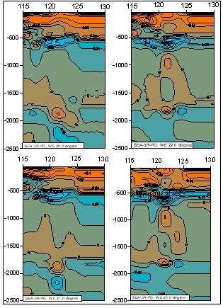
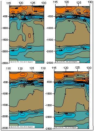
II. 3D P-VELOCITY MODEL OF THE BOUNDARY ZONE
BETWEEN SOUTH CHINA CONTINENTAL REGION AND PHILIPPINES OCEAN PLATE
The 3D P-velocity model of the mantle under Taiwan region and its surrounding is received in
context 3D P-velocity model of the mantle under Eurasia
by Taylor¢s approximation method for
the seismic tomography problem of the arrival times, which was developed by
V.S. Geyko [1]. The used method has a number of advantages before a method of
classic linearization of the decision of the similar problems, one of which is
independence of a choice 1D reference velocity model. Our model is performed by
horizontal sections through 25 km at the depth of 50-2500 km and vertical
sections (longitudinal and latitude) through 1o in the same depths.
Horizontal sections introduced by true velocity with separation on high and
low, concerning 1D reference model, which received for our 3D mantle P-velocity
model under Eurasia as average velocities, vertical sections - in residuals,
concerning the same reference model.
Velocity layers characterize the mantle under
Taiwan region as a whole: 1) Low-velocity upper mantle (depths of 50 - 400 km); 2) High-velocity
transition zone of upper mantle (400 - 600 - 650 km); 3) Low-velocity
middle mantle (600 - 1700 km); 4) High-velocity zone of deviation-II (1700-2200 km); 5) And
low-velocity low mantle.
1. Horizontal sections
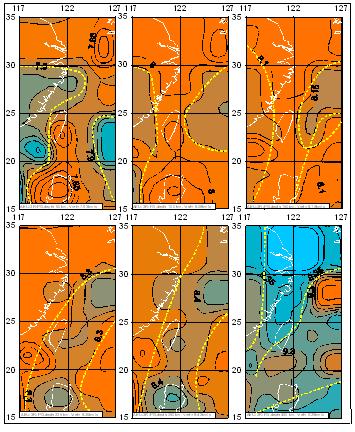
The boundary position of island-arc systems is
fixed by morphological features of top of low-velocity upper mantle at the
depth of 50 km a chain of velocity anomalies union by an isoline of 7.9 km/s
(Fig. 1).
These features permit to estimate the morphology
and depth of the seismic lithosphere bottom.
It increases to 70-80 km under oceanic and continental regions and decreases
more than 50 km under island-arc system. The bottom of underlying layer has
conformed turn and thickness of the depth about 200 km. In a mean part of this
layer anomaly region has longitude direction as continuity Luzon-Taiwan part of
boundary and flow together with low-velocity mantle layer East-China Sea.
Its observed velocity inversion in the part of the Ryukyu arc (horizontal
sections of 100-150 km (Fig. 1) is detected.
The boundary of velocity anomaly layers, which
include island-arc system, restores to the depth of 175-225 km (Fig. 1) at the
same time velocity inversion to the relatively high.
Below it is a spreading
of high-velocity region under Luzon Island and East China Sea.
Between East China Sea and Luzon island one
can see the region, which separates the continental upper mantle from oceanic
one. This boundary structure passes to the north-west under south-east China
margin. North-east its direction changes to longitude to the south.
Transitional zone of upper mantle observed at the depth of 250-450 km and
characterizes by high velocity.
REFERENCES
1. Geyko
V.S., 2004. A general theory of the
seismic travel-time tomography. Geophysical J., 26/2 : 3-32.
2. Gilmanova G.Z., Podgornyj
V.Ja., 2007. Gravitational model of rock
sphere of an island Taiwan
(on a profile Taiwan Strait - an island Taiwan). The West Philippines hollow // Pacific
geology, 26/3 : 34-45.
3.
Gilmanova G.Z, Kulinich R.G, Podgornyj V.Ja., 2007. Density rock sphere models in a zone of an
articulation of a table of Philippine Sea with the Asian continent around
island Taiwan // the Far
East seas of Russia.
In 4 кн. - Кн. 3:
Geologic and geophysical studies / Отв. ред. R.G.Kulinich., Pp. 358-372.
4. Konstantinovsky E.A., 2003. Tectonics of east
suburbs of Asia: Structural progressing and
geodynamic modelling. Тр. ГИН, RAS, 549, 224 pp.. Мoskva.