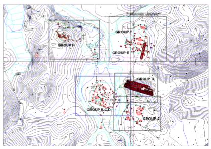
Figure 1. Map of Mỹ
Sơn archaeological site.
GEOPHYSICAL
SURVEYS AT ARCHAEOLOGICAL SITES IN VIỆT NAM: CASE STUDY ON MỸ SƠN SANCTUARY
AND THĂNG LONG IMPERIAL CITADEL (OLD HÀ NỘI)
1ĐINH VĂN TOÀN, 1ĐOÀN
VĂN TUYẾN, 1TRỊNH VIỆT BẮC, 1LẠI HỢP PHÒNG,
1TRẦN ANH VŨ, 2MAURA CUCARZI, 2PAULO CONTI, 3NGUYỄN
VĂN GIẢNG
1Institute of Geological
Sciences, VAST, Hà Nội;
2Fondazione Ing. Carlo Maurilio Lerici, Polytechnico di Milano,
Italia ;
3Institute of Geophysics,
VAST, Hà Nội.
Abstract: Recently, geophysical survey, a
non-destructive method for investigating the subsurface medium, is increasingly
used in archaeological research due to its effectiveness in locating and
identifying buried archaeological sites, as well as determining the physical
properties and geometrical dimensions of buried structures. This paper presents
applied results of some geophysical methods: magnetometry, electrical and
electromagnetic, seismic techniques and ground penetrating radar at two
archaeological sites in Việt Nam: Historical World Heritage Mỹ Sơn Sanctuary
(Quảng Nam Province) in IV-XIII centuries and Thăng Long Imperial Citadel (Old
Hà Nội) in XI Century.
I. INTRODUCTION AND SITE HISTORY
1. Mỹ Sơn is situated in
In 1999, Mỹ Sơn was recognized
by UNESCO as a world heritage listed site. The French archaeologists divided
the architectural works at Mỹ Sơn into 10 principal groups, A, A', B, C, D, E,
F, G, H, K to enable a system of labelling sites by capital letter and number (Fig.
1).
Mỹ Sơn was once a veritable forest of
towers, many of them were destroyed by the ravage of time and war. This unique
site is now in a state of significant disrepair, urgently requiring
conservation efforts. In order to evaluate the evident
of the burried remains and underground structures the geophysical investigation
was suggested.
From its inception, one of
the tasks of the Mỹ Sơn Conservation Project was delimiting the known
archaeological areas and locating other possible monument remains still under
the ground. The geophysical investigations carried out at Mỹ Sơn have been also
aimed to investigate changes in physical properties, in both vertical and
horizontal directions, related to the degradation process in the subsurface
environment, which affect the stability of the monument foundation structures.
To solve these problems,
three methods were used: resistivity survey for both horizontal and vertical
exploration, magnetic measurement of the earth’s magnetic field and magnetic
susceptibility measurement of the horizontal. Among these, the resistivity and
magnetic susceptibility measurements were conducted by a team of geophysicists
from the
Figure 1. Map of Mỹ
Sơn archaeological site.
2. The
Thăng Long Citadel, which is the present Hà Nội
centre, was chosen by Lý Thái Tổ, the founding king of the Lý Dynasty, as the
capital of Đại
In the 2004, after more one-year of investigation
and archaeological excavation near the Ba Đình Assembly Hall 20.000 m2 of
land surface were opened. Reaching about 4 m in depth encountered building
remains and cultural layers going back to Fifth-Sixth Century very far before the date of Hà Nội foundation (1010)
according historical sources (Fig. 2). The event has been attracting the
attention of the Vietnamese Government, Hà Nội Municipality, Hà Nội UNESCO
Office and many international experts from several countries.
The present relic complex is located in Ba Đình
District (Fig. 2), roughly surrounded by Nguyễn Tri Phương, Phan Đình Phùng,
Điện Biên Phủ, Trần Phú, Hoàng Văn Thụ and Hùng Vương Streets. Relics in the
areas of Forbidden City and Imperial Citadel situated on the central axis of
the old citadel are the Cửa Bắc (North Gate), Hậu Lâu,
The Cultural Historical Complex of Thăng Long - Hà
Nội can be compared with such World Cultural Heritages as the Complex of Huế
Monuments (Central Việt Nam) and the Historic Monuments of Nara Palace (Japan).
As compared to
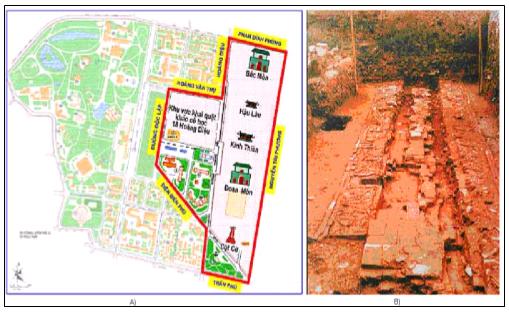
Figure 2. Location of the Imperial Citadel and
excavated area in the map
of Ba Đình Complex (left); buried
architectural remains at the bottom
of excavation near Doãn Môn (right).
The
archaeological remains in Hà Nội is destroyed and buried by natural geological
hazards and urban development. The old Hà Nội City is situated in the low
topographic land of the bank of
The
problem how to continue the necessary investigation in the nearby present
excavation is important practice. In fact, the results of excavation have been
showing that, the different cultural layers with important archaeological and
architectural remains are buried and continue to extend in all directions.
Because the area is in the important place of the Hà Nội City, it is very
difficult for archaeologists to obtain the permission for continuing the
excavation.
The main goal of the geophysical investigation is
to locate evidences, if possibly, to map and determine the structures
concerning to the distribution of buried archaeological remains. Practically,
many similar problems have been solved successfully in many countries of the
world by using number of geophysical methods, such as electrical tomography,
ground penetrating radar, seismic and magnetic surveys. In order to overcome
the difficulties in urban conditions for conventional methods, an
electromagnetic technique based on non-grounding electrical and magnetic
measurements of line dipole source produced by the Russian Company ERA was
tested. In this paper an analysis of the obtained results by all methods in the
testing areas with known buried archaeological targets is presented and
discussed.
II. RESULTS OF GEOPHYSICAL INVESTIGATIONS
1. At Mỹ Sơn Site
Results of Magnetic Prospecting
During the 2004 research
season, an intensive magnetic prospecting campaign was carried out on the area
of G Group, to detect and locate unknown buried structures. In this case a grid
of one-metre side was used to provide a detailed map. The G Group area is a
relatively flat area on the top of a hill of nearly rectangular shape (Fig. 1).
The long side of the hill stretches in the NW-SE direction. The archaeological
complex here comprises five monuments; four of them were almost completely destroyed:
the remains take the form of footwalls, with a height of less than 1 m
(monuments G2, G3), or are completely erupted (G4, G5).
The magnetic map (Fig. 3)
shows many magnetic anomalies: some produced by the existing building, by
large-scale dumping in the northeast sector; others were produced by bomb
fragment remains and modern features. The anomalies indicated by dotted lines
on Fig. 3 were produced by excavation trenches made by Parmentier at the
beginning of the last century. Clear groups of anomalies are produced by a
laterite enclosing wall, by dumping during the previous archaeological
excavation (Parmentier) and by many modern features (remains of shell bombs,
etc.), as indicated on the map in Fig. 3. There is no trace of other brick structures.
The investigations were
concentrated in the areas of G Group and E7 monument aiming to locate
sub-surface inhomogeneities related to archaeological remains; 2D and 3D
techniques were applied.
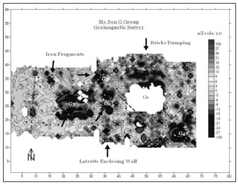
Figure 3. Geomagnetic map of G Group in Mỹ Sơn.
In the area of G Group, 21
profiles were designed. The distance from profile to profile is 2 m, while the
distance between the measurement points (minimum distance between electrodes)
along each profile is 1 m. The separation (level) of the electrode arrays
ranges from 8 to 14 times. This allowed us to investigate on a maximum depth of
about 4-7 m. In the area of E7 monument investigations were conducted along
three parallel profiles. The central profile passes along the axis of the foundation
surface of the monument interior; the two others are parallel one to another,
distributed outside the monument. The distance between the profiles is about
3.5-4 m, and the distance between the measurement points along each profile is
1 m.
Data interpretation was
carried out by using both 2D and 3D techniques. We used the DC2DSIRT software
for 2D, and IP3D software for 3D employing the Simultaneous Iterative
Reconstruction Techniques (SIRT) [1]. In the calculation, the initial model was
chosen by direct observation of resistivities. The 2D inversion results were
presented in the form of geoelectrical cross-sections, through which we were
able to understand the resistivity contrast along the vertical plane as well as
along each profile. The results of 3D inversion allowed us to calculate the
distribution of resistivities on the plane at different depth levels, so as to
see the features of the sub-surface environment on the whole investigated area
[4, 5].
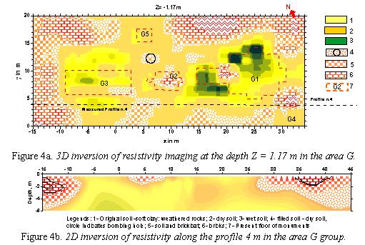
We can see the more
intuitive horizontal distribution of resistivity on the scheme of structure at
depth levels Z = -0.64, -1.17 and -1.8 m derived from the 3D inversion.
Analysis of results shows that the 3D inversion allowed us not only to reveal a
smaller size of resistivity anomalies, but also better to gauge the dimensions
and shape of the buried objects (Fig. 4a).
From a depth of more than 2 m below the land
surface, the environment shows strong differentiation in resistivity value
(Fig. 4b). The higher resistivity anomalies related to construction materials
(refined bricks) are separated from the monuments which were scattered and then
buried in the surrounding environment. In addition, the higher or lower
anomalies, compared with the background value, can be produced by other
man-made systems: in some locations, large holes created by bombing and
explosions during the war, etc... At levels deeper than 3 m, all the
cross-sections show the resistivities becoming much more stable. Experience in
those locations suggests that the range of resistivity reflects the presence of
soil of high clay content produced from the original sandstone and siltstone by
a process of weathering.
2. At Thăng Long Citadel site
In order to evaluate the evidence of the buried
remains and structures on the geophysical responses the surveys by conventional
methods: resistivity, seismic, magnetometry and ground penetrating radar were
carried out. The field observation at the site met some difficulties due to
high level of noise produced by urban activities. In addition, surface layer of
pavement, recent constructions and underground system of sewers, water supply
pipes are obstacles, not only for field works, but either decrease signals from
buried archaeological targets. All these effects are the reason of low quality
of observed data; therefore the surveyed results not all away satisfied for
solving proposed problems.
In combination with conventional methods the new
electromagnetic ERA equipment was tested. The obtained results showed that, it
allows overcoming difficulties in both field survey and improve some advantages
for mapping buried structures at the site.
Resistivity tomography could employed only
along single profiles mainly in narrow band of garden or margin of the roads in
both Ba Đình excavation and Imperial Citadel.
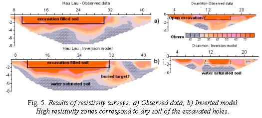
The results in Resistivity surveys at two excavated
sites are presented in Fig. 5: 1) In the Doãn Môn Gate the surveyed profile is
distributed nearby the open excavation, where is a buried architectural remains
at its bottom (Fig. 2, right); 2) In the Garden of Hậu Lâu residence, the
profile is arranged along the axis of excavation filling soil. The high
resistivity anomalies correspond to the shape of noticeable excavations. Below
these sections the low resistivity zones denote saturated mud and silt. One
isolated anomaly with high resistivity distributed under the marks 32-35 m of
profile in the Hậu Lâu can be related to buried target of remain? The brick
road in the bottom of excavation in Doãn Môn is not identified in the
cross-section of resistivity model (Fig. 5b). The no light contrast of
resistivity of soil and buried remains caused by noise, that decreases
resolution of the spread of array in resistivity tomography.
Ground Penetrating Radar (GPR) profiles were
carried out along the roads and in the garden areas. The 500 MHz shielded
antenna was used. In general, it allows to investigate to the depth of about
3.5 m.
Fig. 6 shows a radargram along the profile passing
the same filled excavation in
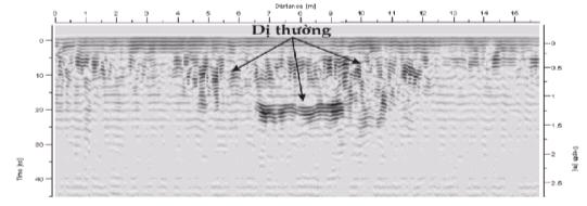
Fig. 6. Result
of GPR survey in the garden of the Hậu Lâu residence
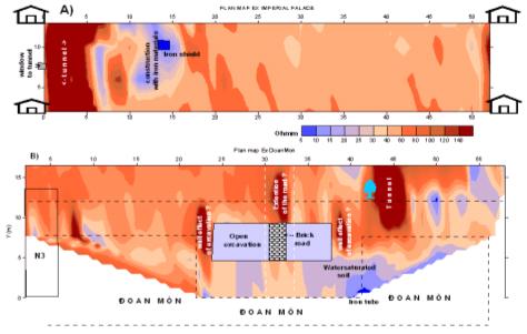
Fig.7. Plan-view
maps of Ex component at
surveyed sites:
a) Imperial (Dragon) Palace; b) Doãn Môn Gate
Magnetic and seismic surveys: The results of theoretical and experimental
research show that, magnetic contrast between some archaeological materials
(especially burned bricks and its brickbat) and soil is always exist [3]. Due
to the main materials of ancient construction here made by burned bricks and
flagstones, the exploration was conducted in some limited areas. The high noise
level caused by the urban systems became the obstruction to identify the buried
remains. Thus, in the areas of Hoàng Thành the magnetic survey is mostly a
non-productive one.
In the areas of Hoàng Thành were also carried out
the seismic explorations along a number of profiles. The results reflect the
subsurface layered geological environment, the underground trench vestige as
well as some indications related to the buried remains.
Non grounding electrical and magnetic surveys: The main advantages of the new equipement ERA are sensitive to the
ferromagnetic content in soil, so its use allows us to detect more easily a
small change in the ground environment. Small size, light weight and
non-galvanic contact of measurements are strong points of the equipement, that
allow us to easily and quickly carry out the exploration in complicated areas,
such as inside the residences, urban locations etc...
For the
measurement in Hoàng Thành area, the linear dipole source with length of
150 m and frequency of 625 Hz were installed outside the investigated area. The
electrical Ex and magnetic Hz
components at the same frequency are measured at distance in every 1 m along
profiles distributing parallelly the dipole source.
The collected data are concentrated at sites of
Thăng Long Citadel: 1) around the excavation in Doãn Môn Gate, that is related
to the buried brick road – a typical remain at the site; 2) area of Imperial
(Dragon) Palace (Kính Thiên), where is a known tunnel – facility of underground
structure. These examples are chosen because all the mentioned above objects are known and we can use them for evaluate
the exploration.
At the
At the Doãn Môn site (Fig. 7b), evidence of
recovered brick road at bottom of the excavation is identified by a high
resistivity anomalies Ex in both
northern and southern parts of the map. The higher intensity at the nothern
part, may be produced at the same time by the brick road and additional effect
from the undergronud trench there. The highest resistive anomaly in the
northeastern award of the excavation reveals the signal of the known tunnel.
The plan map can be divided in two parts with different features: left pattern
of the map with relatively high resistivity indicates dry pavement, right one
with low resistivity related to the water saturated soil. The two isolated high
resistive anomalies distributed in both margins of the open excavation may be
explained by a “wall effect” of the EM field. The conductive anomaly in the
south-eastern edge of the plan map is related to iron tube going out in the
surface.
III. CONCLUSIONS
1. The surveying results by using magnetometry,
2D-3D resistivity, magnetic susceptibility at My Sơn site successfully provide with
informations about archaeological remains, in fact the magnetic and magnetic susceptibility anomalies indicate a large
quantity of bricks scattered throughout the area, the laterite enclosing wall,
remains of bomb fragments and trenches of Parmentier’s excavations. Based on
the results obtained from 2D-3D resistivity distribution, we can
establish a risk map at different depths (0.64, 1.17 and 1.8 m in G Group)
indicating (or describing) features of both the environment and the buried
remains under the investigation area.
2. A lower efficiency of identification of buried
remains by geophysical investigations in Thăng Long Citadel (Hà Nội) is caused
by the complication of urban systems, such as the concrete and asphalt surface,
dense construction, high conductivity in the near surface water saturated
layer, water supply pipes and electric energy transmition line systems etc.
3. The EM technique with linear dipole source at
625 MHz and non grounding electrical Ex
measurements by ERA equipment are possible to assert that: the underground
structures of concrete construction as tunnel is revealed by highest anomalies Ex at both
Based on the tested results, the combination of
electromagnetic and conventional
geophysical methods is more expected for successfully solving proposed
problems at archaeological Thăng Long site in future. This result is useful
experience for investigating other archaeological and historical sites in Việt
Acknowledgements: This work is partially supported
by International and Vietnamese Agencies: UNESCO, Italian-Việt Nam Government
Committee for Scientific Cooperation, Việt Nam National Research Fund of Basic
Sciences.
The authors are grateful to the director and
managers of Hà Nội ancient wall – Cổ Loa vestiges preserved Centre for the
helful cooperation.
REFERENCES
1. Barker
R.D., 1992. A simple
algorithm for electrical imaging of the subsurface. First break, 10/2 : 58-64.
2. Binda Luigia, Cristina Tedeschi et al., 2006. Characterization of material sampled from some My
Sơn Temples. 7th Conf. of ICCE,
3. Cucarzi Mauro, K.M. Ermukhin et al.,
2001. Method of volume dipole sources for solving problems of stationary
magnetic and electrical prospecting. Prospezioni
archeol. - Fondazione Lerici Quaderni,
2 : 183-202.
4. Đoàn Văn Tuyến, Đinh Văn Toàn et al.,
2005. Geophysical methods in archaeological investigation and some applied
results. Proc. Nat. Conf. on Engin.
Geol. and Env., pp. 216-224. Hà Nội.
5. Đoàn
Văn Tuyến, Đinh Văn Toàn, Trần Cánh,
Trịnh Việt Bắc, Lại Hợp Phòng, 2005. Phương pháp địa vật lý phục vụ công tác khảo cổ và một số kết quả ứng
dụng. Tt báo cáo HNKH toàn quốc Địa chất công trình và Môi trường, tr.
216-224. Hà Nội.
6. Parmentier H., 1909. Inventaire
descriptif des monuments Chams de l'Annam. Paris.
7. Sapozhnikov B., 2002.
Resistivity method without grounding. Ann. Geophys., 14 : 141-162.
8. Won J. et al.,
1996. GEM-2, a new multifrequency electromagnetic sensor. J. of Env. and Engin. Geophysics,
6 :
448-451.