REALISTIC ESTIMATION OF SEISMIC GROUND MOTION
IN HÀ NỘI CITY USING SYNTHETIC SEISMOGRAMS
1NGUYỄN HỒNG PHƯƠNG, 1CAO
ĐÌNH TRIỀU,
2ROMANELLI F., 2VACARRI F.
1Institute of Geophysics, VAST, 18 Hoàng Quốc Việt, Cầu Giấy, Hà Nội;
2 Department of Earth Sciences, Trieste University, Via Weiss 4,
3417 Trieste, Italia.
Abstract: For urban
areas, particularly where very limited recording is available, the theoretical
computations of synthetic seismograms play important role in the seismic risk
analysis and loss estimation procedure. In such cases, the problem of the
seismic ground motion estimation before the occurrence of a damaging earthquake
can be solved if detail of the subsurface structure underneath the city and
characteristics of seismic source are known.
This
paper introduces a new, firstly applied in Việt Nam, with modelling approach,
method for estimating local site effects caused by earthquakes. A ground motion
scenario is developed for a downtown area of Hà Nội City, with a priory
information on source and structure at local and regional scales. The method,
taking into account the conditions of a laterally heterogeneous anelastic
media, results in a set of synthetic seismograms with three components of
motion, including acceleration, velocity and displacement. The obtained
synthetic seismograms provide an excellent choice of the realistic input for
seismic risk analysis and loss estimation for Hà Nội City.
The results obtained for downtown area of
Hà Nội show the fact that the local site effects might considerably exceed the
average value of ground motion estimated for the whole area. The determination
of the spectral amplification at a certain site plays significant practical
role in seismic engineering and antiseismic design, as the amplification
factors indicated in building code are usually limited for a fixed range of
ground motion values and for a certain soil types.
I. INTRODUCTION
Seismic
hazard and seismic risk assessment are two consecutive and interdependent steps
of a whole procedure. The typical seismic hazard problem essentially lies in
the determination of the effects associated with earthquakes, on both regional
and local scales. The outputs from
seismic hazard assessment, which are usually presented in terms of shaking
maps, representing the spatial distribution of strong ground motion
parameters, such as peak ground acceleration Amax, particle
ground velocity Vmax or peak ground displacement Vmax, are used as input for the risk assessment
procedure.
The
use of a single value of a ground motion parameter for seismic risk analysis at
a point can lead to incorrect risk estimations, since that parameter itself can
not express all the effects associated with the ground shaking. For example,
information on the frequency content and the duration of seismic wave-train,
which can greatly affect the ground behaviour, is not always included in a
single value of PGA. Therefore, a precise estimation of seismic risk can be
obtained only when the effects of local ground shaking amplification or site
effects are taken into account. These effects are associated with
near-surface geological and topographic conditions of the study area and often
occur in the regions with strong impedance contrast between near-surface
sedimentary deposits and underlying bedrock. In such cases, the trapping of
seismic energy at the boundary of soft sediment and bedrock layers and the
onset of vertical resonances can lead to the considerable increase of ground
motion amplitudes. In fact, the macroseismic observations of the World’s
destructive events show the strong influence of site effects under the
megacities, since most of the urban areas are settled on sedimentary basins or
river valleys.
There
are two approaches of reliable definition of the seismic input at a given site.
The first approach is based on the analysis of the available strong ground
motion data, recorded at seismographic networks, by grouping of the seismograms
with similar source, path and site effects. This approach usually can not be
widely applied due to the scarce ground motion data, being collected only in
developed countries, or where destructive earthquakes occurred. The second
approach is based on modelling techniques, developed from knowledge of the
seismic source process and the propagation of seismic waves, which can
realistically simulate the ground motion associated with a given earthquake
scenario.
This
paper introduces a method for assessment of seismic local site effects
following modelling approach, firstly applied in Việt Nam. A ground motion scenario is
proposed for a downtown area of Hà Nội City, with pre-defined source parameters
and structural models developed for both regional and local scales. A hybrid
calculation technique is used for Hà Nội with an assumption of a laterally
heterogeneous anelastic media. The results are presented in the form of
synthetic seismograms showing three components of such ground motion parameters
as acceleration, velocity and displacement.
A complete set of synthetic seismograms obtained provides an excellent
choice of the realistic input for seismic risk analysis and loss estimation for
Hà Nội City.
II. SEISMOTECTONIC CHARACTERISTICS OF THE HÀ
NỘI AREA
The
tectonic activity of Hà Nội area is controlled by several seismically active
fault systems, crossing through or near the city territory. The most
significant fault zones are Red River (Sông Hồng), Chảy River
(Sông Chảy), Vĩnh Ninh, Lô River (Sông Lô) and Đông Triều - Uông Bí ones [5, 10].
The Red River fault zone separates
the South China microplate with the Northwest Việt Nam multistage folded domain.
Starting from the southeast of Himalaya range, this zone stretches along the Red River valley, gone through the Vietnamese territory
to the Bắc Bộ Gulf, with a total length of over 1000 km and a narrow, straight
width. Being an ancient zone, the Red River
fault zone has been activated during a long development history and plays an
important role in tectonic framework of the Southeast Asian region. According
to the geophysical and geological data, it is formed by a deep-seated main
fault breaking through to the Moho’s surface. The fault plunges northeastward,
having the dip angle of 78-80o and movement of normal right-lateral
strike slip type and with a speed of 1 mm/year.
The Chảy
River fault zone is
characterized by a deep-seated fault with rooted throughout the Earth’s crust,
which branched off the Red River at Bản Phiệt (Phiệt Village)
and stretching in NW-SE direction. The main fault plunges northeastward with a
dip angle of 80o. The Chảy River fault zone is believed to control the
occurrence and development of the Red River
graben.
The Vĩnh Ninh fault zone crosses
the southern part of Hà Nội territory, with a total length of over 30 km and
NW-SE direction. The main fault is clearly depicted in the surface as a
small-sized rupture zone and has the normal type with dip angle of 70-720 plunging
northeastward. The dip angle increases with depth until it reaches the depth of
18-20 km. The vertical amplitude of the fault reaches 2-3 km.
The
Lô River fault zone stretches
in NW-SE direction, being a part of the Red River - Chảy River
faults system, with similar dynamic regime and development characteristics. The
Lô River main fault appeared since PZ2 and is known as a normal
fault plunging southwestward.

Figure 1.
Seismotectonic scheme of the Hà Nội City
The Đông Triều - Uông Bí fault zone stretches
in NW-SE direction. It is characterized by a main fault of 30 km depth and
70-720 dip angle plunging northeastward. In present time,
the Đông Triều - Uông Bí fault system is affected by a left-lateral movement,
while the Red River fault system is affected
by a right-lateral movement.
It
is believed that the occurrence of earthquakes is caused by the movement of
geoblocks lying along the active fault plane. As a matter of fact, in the Hà
Nội area, earthquakes with intensity VI and over (M³4.5) have occurred on the
above described active deep-seated faults. The most active tectonic movement is
observed on the Chảy river and Đông Triều - Uông Bí fault systems, where a chain
of medium earthquakes had been recorded. Three largest events belonging to the
Đông Triều fault are the Mạo Khê earthquake in 1903, the Bắc
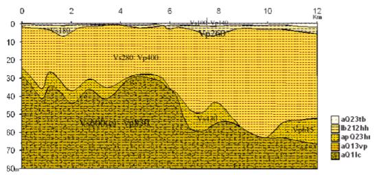
Figure
2. Cross-section along the profile showing the local near surface sediment
layers
with geological and geotechnical information
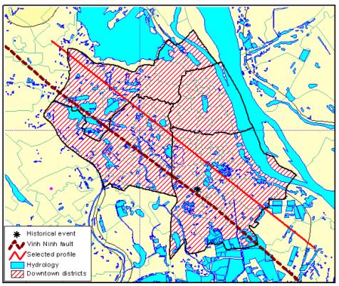
Figure 3. A profile
adopted for site response assessment in downtown area of the Hà Nội City
Table 1. Structural
parameters for the M2 (bedrock) model
|
Thickness
(km)
|
ρ
|
VP
|
VS
|
QP
|
QS
|
Depth
(km)
|
Layer name
|
|
2
|
2.20
|
2.20
|
1.27
|
220.00
|
100.00
|
2
|
Phong
Châu
|
|
5
|
2.60
|
4.60
|
2.70
|
220.00
|
100.00
|
7
|
KZ
|
|
10
|
2.80
|
6.40
|
3.60
|
440.00
|
200.00
|
17
|
Cristal
Shield
|
|
15
|
2.90
|
6.50
|
3.70
|
440.00
|
200.00
|
32
|
Moho
|
|
70
|
3.15
|
7.90
|
4.57
|
440.00
|
200.00
|
102
|
Upper
Mantle
|
Table 2. Structural parameters for the M3 (bedrock+1 layer) model
|
Thickness
(km)
|
ρ
|
VP
|
VS
|
QP
|
QS
|
Depth
(km)
|
Layer
Name
|
|
0.1
|
1.95
|
0.83
|
0.60
|
110.00
|
50.00
|
0.1
|
Phù Cừ
|
|
2
|
2.20
|
2.20
|
1.27
|
220.00
|
100.00
|
2.1
|
Phong
Châu
|
|
5
|
2.60
|
4.60
|
2.70
|
220.00
|
100.00
|
7.1
|
KZ
|
|
10
|
2.80
|
6.40
|
3.60
|
440.00
|
200.00
|
17.1
|
Cristal
Shield
|
|
15
|
2.90
|
6.50
|
3.70
|
440.00
|
200.00
|
32.1
|
Moho
|
|
70
|
3.15
|
7.90
|
4.50
|
440.00
|
200.00
|
102.1
|
Upper
Mantle
|
Table 3. Structural parameters for the M4 (bedrock+2 layer) model
|
Thickness
(km)
|
ρ
|
VP
|
VS
|
QP
|
QS
|
Depth
(km)
|
Layer
Name
|
|
0.06
|
1.80
|
0.40
|
0.26
|
110.00
|
50.00
|
0.06
|
|
|
0.1
|
1.95
|
0.83
|
0.60
|
110.00
|
50.00
|
0.16
|
Phù Cừ
|
|
2
|
2.20
|
2.20
|
1.27
|
220.00
|
100.00
|
2.16
|
Phong
Châu
|
|
5
|
2.60
|
4.60
|
2.70
|
220.00
|
100.00
|
7.16
|
KZ
|
|
10
|
2.80
|
6.40
|
3.60
|
440.00
|
200.00
|
17.16
|
Cristal
Shield
|
|
15
|
2.90
|
6.50
|
3.70
|
440.00
|
200.00
|
32.16
|
Moho
|
|
70
|
3.15
|
7.90
|
4.57
|
440.00
|
200.00
|
102.16
|
Upper
Mantle
|
Table 4. Structural parameters for the M5 (bedrock+3 layers) model
|
Thickness
(km)
|
ρ
|
VP
|
VS
|
QP
|
QS
|
Depth
(km)
|
Layer
name
|
|
0.05
|
1.80
|
0.40
|
0.26
|
110.00
|
50.00
|
0.05
|
-
|
|
0.1
|
1.95
|
0.83
|
0.60
|
110.00
|
50.00
|
0.15
|
Phù Cừ
|
|
2
|
2.20
|
2.20
|
1.27
|
220.00
|
100.00
|
2.15
|
Phong
Châu
|
|
5
|
2.60
|
4.60
|
2.70
|
220.00
|
100.00
|
7.15
|
KZ
|
|
10
|
2.80
|
6.40
|
3.60
|
440.00
|
200.00
|
17.15
|
Cristal
Shield
|
|
15
|
2.90
|
6.50
|
3.70
|
440.00
|
200.00
|
32.15
|
Moho
|
|
70
|
3.15
|
7.90
|
4.50
|
440.00
|
200.00
|
102.15
|
Upper
Mantle
|
Giang
earthquake in 1961 (M = 5.6) and the Yên Thế earthquake in 1987 (I = VI-VII).
Another row of events with intensity VII-VIII are believed to be originated
from the Chảy River fault in the XIII century
(historical earthquakes of 1277, 1278 and 1285). On the territory of Hà Nội City,
the only recorded event was the Yên Lạc earthquake in 1958 (M = 5.3). Outside
the city, in Lục Yên (Yên
Bái Province),
two consecutive events with intensity VII occurred in 1953 and 1954. Weaker and
less frequent events have been observed along the Red
River, Vĩnh Ninh and Lô River fault zones, with intensity not
exceeding VI.
Fig.
1 shows a scheme of simplified above described fault systems with seismicity of
the Hà Nội area.
III. DEVELOPMENT OF A GROUND MOTION SCENARIO
FOR HÀ NỘI CITY
A ground motion scenario is developed for site
response assessment in downtown area of Hà Nội City, that combines two models:
1) seismic source model (or scenario earthquake) and 2) a set of structural
models for the study area at two scales: regional and local. With this approach, the source, path and site
effects are all taken into account, and therefore, it is possibly to carry out
a detailed study of the wave field that propagates at large distances from the
epicenter.
The definition of an earthquake scenario in Hà Nội is based on the
fault-source model developed for Việt Nam, with assumption that earthquakes are
originated on seismically active tectonic faults [8, 9]. For this study, an earthquake scenario was defined as originated
from the Vĩnh Ninh Fault, with moment magnitude MW = 5.6 and focal
depth H = 10 km. Information on geometry and motion mechanism of the Vĩnh Ninh
fault were taken from GIS database of seismically active faults for the
territory of Việt Nam and adjacent areas [9].
For
the rest part of ground motion scenario, two types of structural models are
developed for the Hà Nội area. The local model represents near-surface soft
sediment layers lying beneath the downtown area of Hà Nội City, while the
regional model represents average structure properties for a much larger area
including Hà Nội City.
For defining a local model named as M1, a
geological cross-section along a 12 km long profile is adopted. The
selected profile is parallel with the Vĩnh Ninh fault, crossing several
downtown districs of Hà Nội (Fig. 2). Geotechnical and geophysic data available
for each layer of the cross-section are taken from previous studies [9, 10].
At regional scale, four bedrock models are
created for the Hà Nội area using geophysic data obtained from previous studies
[2]. The simplest model includes only bedrock base of 4 layers. The other ones
are created with one or two more thin layers added on the top of the bedrock
base. The regional models are named as M2, M3, M4 and M5, respectively. The
parameters for each layer of the regional models of Hà Nội area are listed in
Tables from 1 to 4.
IV. SITE RESPONSE ASSESSMENT USING SYNTHETIC
SEISMOGRAMS
Fäh et al., 1993
developed a hybrid method that combines the modal summation technique, valid
for laterally homogeneous anelastic media, with finite difference, and
optimized the advantages of both methods [3, 4]. Wave propagation is treated by
means of the modal summation technique from the source to the vicinity of the
local, heterogeneous anelastic structure that is modelled in detail. A
laterally homogeneous anelastic structural model is adopted, which represent
the average crustal properties of the area. The generated wavefield is then
introduced in the grid that defines the heterogeneous area and it is propagated
according to the finite-difference scheme. Schematic representation of the
hybrid technique is given in Fig. 4. The hybrid method has been successfully
applied for several megacities of the world [8].
For estimating the local
site effects in downtown area of Hà Nội City, the hybrid method is applied
using the ground motion scenario described in the previous section. It is
assumed that seismic waves originated from the source (earthquake scenario) is
propagated through a layered media (of regional and local structure models) and
recorded at receivers, located along profile at the sites with equal distances
from each other, and the synthetic seismograms are computed for each site.
The calculation procedure
consists of the following two steps:
1. Computation of synthetic seismograms for 1D layered
regional structural models, namely M2, M3, M4 and M5 bedrock models, with the modal summation technique;
2. Computation of synthetic seismograms for 2D
laterally heterogeneous anelastic media with the hybrid technique, using a
combination of the local model M1 with one of the regional model M2,
M3, M4 or M5 at a time.
Calculated synthetic seismograms represent three
components of strong ground motion parameters, namely acceleration (PGA),
velocity (PGV) and displacement (PGD). For the 2D model, the method allows to
calculate synthetic seismograms for frequencies up to 10 Hz. Results obtained
for different structural models are compared to study the structural dependence
of ground motion. Fig. 5 shows the synthetic three component accelograms
calculated for 2D free surface model at sites along selected profile. As can be
seen from the seismogram, the value of maximum acceleration reaches 53.28 cm/s2
for vertical component and 50.11 cm/s2 for transverse component,
which are about 2 times higher than the PGA value calculated for the same area
by probabilistic method (which is equal to 22,5 cm/s2) [5, 6].
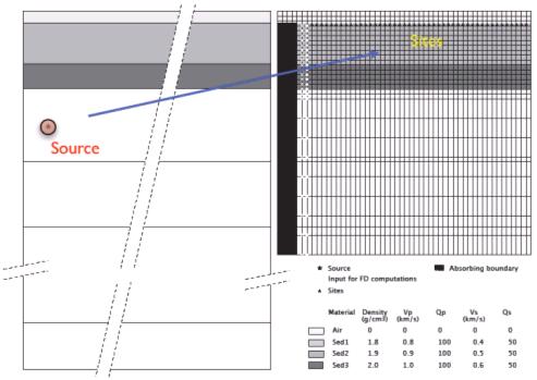
Figure
4. Schematic diagram of the hybrid
(modal summation and finite difference) method.
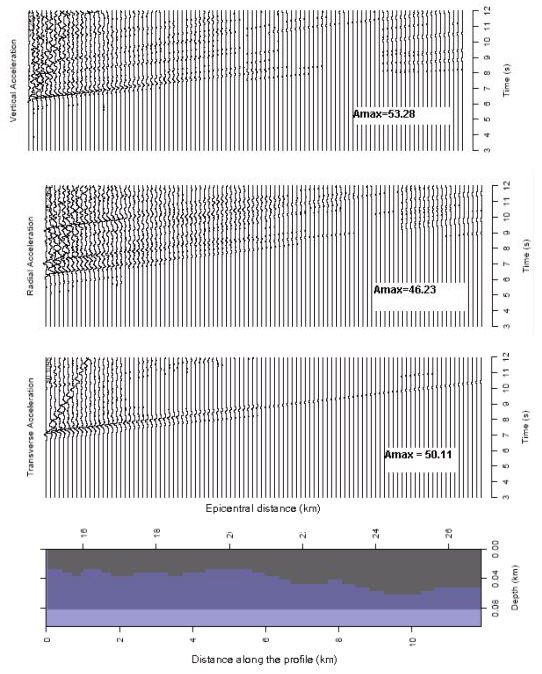
Figure 5. Synthetic
seismograms calculated for 2D free surface model
along the selected profile.
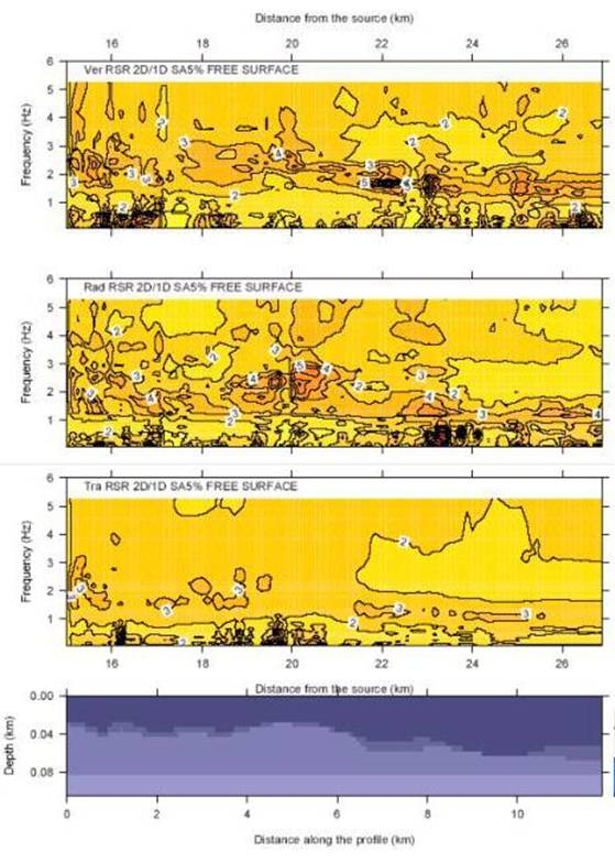
Figure 6. 2D/1D RSRs
versus frequency along the selected profile. From top to bottom: vertical (P-SV
waves), radial and vertical (P-SV waves) components of motion.
To evaluate the local amplification, the response
spectra ratio (RSR), i.e. the response spectra computed (at 5 % damping) from
the signals synthesized along the laterally varying (2D) model normalized by
the response spectra computed from corresponding signals, synthesized for the
bedrock (1D) regional model is calculated at each site. Fig. 7 shows the
variation of the RSR (also called spectral amplification) along the selected
profile, calculated for three components of spectral acceleration, in relation
to epicentral distance and frequency. As can be seen from the figure, at low frequencies
(less than 1 Hz) the ratios are approximately 2 along all profile, but at
higher frequencies, where the wavelengths are comparable to the dimensions of
lateral heterogeneities, the ratios increase. For transverse component, the
amplification reaches maximum value of 3 at frequency range from 1.5 to 2 Hz.
But for vertical and radial components, the amplification reaches the largest
values of 4 and 5 at the frequency range from 2 to 3 Hz. All this
indicates that, due to local effects, one may expect much higher shaking
intensity comparing with the average values estimated for the area [5, 6].
V. CONCLUSIONS
The method presented in
this paper, though firstly applied in Việt Nam, shows a number of advantages.
The seismic hazard and risk assessment for Hà Nội City, due to the limitation
of earthquake and strong ground motion records, requires to resort to broad
band synthetic seismograms, which allow to perform realistic waveform modelling
for varying structural environments, taking into account all associated effects
of source, path and site properties. Each synthetic strong ground motion
scenario, characterized as a function of its damage potential will improve the
experts choices in selecting acceleration histories for various seismic risk
analyses. Development of databases of modelled near-field and soft soil strong
motion seismograms can contribute a great deal to the enhancement of knowledge
in damage potential evaluation.
The results obtained for
downtown area of Hà Nội City show that the local site effects might
considerably exceed the average ground motion value estimated for the area. The
determination of the spectral amplification at a certain site plays significant
practical role in seismic engineering and antiseismic design, as the amplification
factors indicated in building code are usually limited for a fixed range of
ground motion values and for a certain soil types [1].
Acknowledgement
The results presented in
this paper have been obtained during the 2nd meeting/workshop of network
Project “Seismic Hazard in Asia”, co-organized
by ICTP and C-MMACS, March 31 to April 11, 2008. We sincerely thank Prof. Panza G.F., ICTP
and Dr. Imtyiaz Ahmed Parvez, C-MMACS, for organizing the project and providing
us with all facilities to make this work done.
REFERENCES
1. Building Codes of Việt Nam No.375, 2006. Design of structures for earthquake resistance. Hà Nội (in Vietnamese).
2. Cao Đình Triều et al, 2005. Application of high-precision gravity method for
assessment of structural characteristics of the Hà Nội Depression Region. Proj. Final Rep. (in
Vietnamese).
3. Fäh
D., Suhadolc P., Panza G.F., 1993. Variability
of seismic ground motion in complex media: The Friuli area, Italy. In Geoph. Expl. in Areas of Complex Geology, II (eds. Cassinis R.,
Helbig K., Panza G.F.), J. Appl. Geophys., 30 : 131-148.
4. Fäh
D., Iodice C., Suhadolc P., Panza G.F., 1993. A new method for the realistic estimation of seismic
ground motion in megacities: The case of Rome.
Earthquake Spectra, 9 : 643-668.
5.
Nguyễn Hồng Phương, 2002. Assessment of earthquake risk for Hà Nội City.
Final report of Proj. No. 01C-04/09-2001-2. Hà Nội (in
Vietnamese).
6.
Nguyễn Hồng Phương, 2007. Application of GIS
technology for modelling and assessment of urban risk for Hà Nội City. Final
report of Proj.
No. DL/02-2006-2. Hà Nội (in Vietnamese).
7. Nguyễn Hồng Phương, Phạm Thế Truyền, 2007. Development of a fault-source model for earthquake hazard
assessment in Việt Nam J. of Earth Sci., 29/3
: 228-238 (in Vietnamese).
8. Panza G.F., Romanelli F., Vaccari F., 1999. The IUGS-UNESCO
IGCP Project 414: Realistic modelling of seismic input for megacities and large
urban areas. Episodes, 22 : 26-32. New
York.
9. Panza
G.F., Romanelli F., Vaccari F., 2001. Seismic wave propagation in laterally heterogeneous
anelastic media: theory and application to seismic zonation. Advances in Geophysics, 42, pp.1-95. Acad. Press.
10. Vũ
Nhật Thắng (Ed.), 2003. Geology
and mineral resources of Hà Nội City. Dept of Geol. & Min. of VN, Hà
Nội (in Vietnamese).