TOTAL
TROPOSPHERIC WATER VAPOUR AND PRECISION OF THE ABSOLUTE POSITIONING BY GPS IN
VIỆT NAM
1LÊ HUY MINH, 1PHẠM
XUÂN THÀNH, 1NGUYỄN CHIẾN THẮNG,
1TRẦN THỊ LAN, 2R. FLEURY, 2P. LASSUDRIE
DUCHESNE, 3A. BOURDILLON,
4C. AMORY-MAZAUDIER, 5TRẦN NGỌC NAM, 6HOÀNG
THÁI LAN
1Institute of Geophysics, VAST, Hà Nội; 2École Nationale de
Télécommunication de Bretagne, France ; 3Université de Rennes
1, France ; 4Centre d’Étude des Environnements Terrestres et
Planétaires, France; 5Huế University of Natural Sciences, Huế;
6Institute of Physics of Hồ
Chí Minh City, Hồ Chí Minh City
Abstract: In this paper
we present the results of determination of the time variation of the residual
of the daily mean navigation coordinates (de, dn, du) of the three GSV4004 GPS
continuous stations in Hà Nội, Huế and Hồ Chí Minh cities and their
correlations with respect to the daily mean IWV of the atmosphere in the same
position. It found that the residuals du vary day-to-day in the range of about
1-2 m and around the annual period general tendency which is maximum in summer
(June or July) and minimum in winter (December or January), and whose amplitude
is of about ±0.8 m. The annual variation of the IWV is also maximal in summer
and minimal in winter. It is found out that different coordinates have
different correlations with respect to the total tropospheric water vapour. The
residual du has highest correlation with respect to the IWV, their correlation
coefficient are about 0.74 for the Hà Nội station; 0.66 for Huế and 0.255 for Hồ
Chí Minh Cities. The residual de has the negative correlation with respect to
the IWV, their correlation coefficient are about -0.4 for three stations. The
residual dn has smallest correlation with respect to the IWV, about -0.2 or
smaller for all three stations. The correlation coefficients of the monthly
mean residuals du and the monthly mean IWV are of 0.95 in Hà Nội, 0.89 in Huế
and 0.58 in Hồ Chí Minh City. These
results in this paper show that it is necessary to carry out the repeated GPS
measurement for tectonic studies in Việt Nam in winter (dry season) in order to limit the effect of the
atmosphere.
I. INTRODUCTION
The
propagation of signals from GPS (Global Positioning System) satellites to
receivers on the Earth’s surface is considerably affected by the ionosphere and
troposphere. The ionospheric dispersive medium produces a group delay of the
GPS signal, which depends on the total electron density (TEC) of the
ionosphere. Thanks to the double frequency GPS receivers, the TEC could be
calculated using this group delay, which results in the fact that the effect
caused by the ionosphere is eliminated nearly completely in GPS positioning.
The troposphere is non-dispersive, so its influence on the GPS positioning is
more complicated. To determine this influence at this moment, one must use some softwares, such as GAMIT/GLOBE [1,
2, 4], Bernese or Gipsy-Oasis. In the frame of scientific cooperation between
the Institute of Geophysics
and the University of Rennes 1, National High School of
Telecommunication of Brest
(French), three GPS receivers have been installed in Hà Nội, Huế and Hồ Chí
Minh City since the April 2005 and
January 2006. Using the data of these GPS receivers to study the TEC in Việt Nam
and adjacent region has been presented in [8, 9]. This paper presents the estimation
of atmospheric effects on the precision of positioning by three above GPS
receivers in Việt Nam,
basing on the comparison between the residuals of the coordinates determined by
GPS and the integrated water vapour (IWV) from the NCEP-DOE AMIP-II reanalysis
model.
II. DATA AND ANALYSIS METHOD
The
data used in this paper is the continuous data from three GSV4004 Novatel’s GPS
receivers in Việt Nam
[8, 9, 10]. The observables of these receivers are C1, L1, D1, S1, P2, L2, D2
and S2, where C1 and P2 are C/A code and Y code pseudo-ranges, L1 and L2 are
carrier phases, D1 and D2 are Doppler frequencies, S1 and S2 are raw signal
strengths. Using the convert4 program of the OEM4PC
software [10] we could obtain the coordinates and the altitude of the stations
in each observation. From the data series of the ellipse coordinate components
(latitude j and
longitude l in degree;
altitude in m) for each observation interval (1 minute or 30 seconds) in three
stations, we calculate their daily mean values for the 2005-2006 period (2006
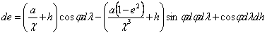
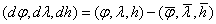
for Huế station). Then the residuals (dj, dl,dh) are computed by the formula:
Where,  are the mean values of
the daily mean data series. The ellipse coordinate residuals (dj, dl, dh) are converted into the local
navigation coordinate residuals (de, dn,
du), where de is east, dn north and du up component residuals in m, respectively by the formula [3, 5]:
are the mean values of
the daily mean data series. The ellipse coordinate residuals (dj, dl, dh) are converted into the local
navigation coordinate residuals (de, dn,
du), where de is east, dn north and du up component residuals in m, respectively by the formula [3, 5]:
Time variation of these (de, dn,
du) data are used to compare with the one of the IWV data at each station.
The
daily IWV data at each station are computed from the NCEP-DOE AMIP-II
reanalysis atmospheric model R-2 [5]. The IWV is the water vapour in different
phases (vapour, liquid, ice...) in the atmospheric column of 1 m2
session at each observation point assuming a homogeneous atmosphere.
In
order to find the relation between the local navigation coordinate residuals
and the IWV, their cross correlations are computed by the formula (between du and iwv) for example:
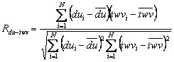
Where,
dui is up component residual, iwvi the IWV on the ith
day,  and
and  are their means, respectively.
III. RESULTS AND DISCUSSION
Time variation of the (de, dn, du)
in Hà Nội, Huế and Hồ Chí Minh cities are presented on the Fig. 1, 2 and 3,
respectively. It shows that the navigation coordinate residuals vary from day
to day, at each station du varies
within a 1-2 m range, meanwhile dn and
de in a 0.5-1 m range. Among three
stations, the daily variation range is smallest in Huế, biggest in Hồ Chí Minh City. It exists clearly an annual variation in du time series, with a maximum in summer
(July), a minimum in winter (January and December). During the 2005-2006
considered period, the variation amplitude of du is about ±1 m, and that
of de and dn is about ±0.5 m. Hence,
the precision of the absolute positioning by GSV4004 GPS receiver is of about
1-2 m, this has the precision quite similar to other receivers [10].
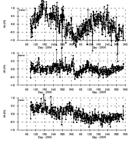
Figure 1. Daily mean de,
dn, du in the Hà Nội station.
The day-to-day IWV data
series from the NCEP-DOE AMIP-II reanalysis atmospheric model in three positions Hà Nội,
Huế and Hồ Chí Minh City are presented on the Fig. 4. It shows that it varies
from day to day with a clearly annual variation, maximum in summer (June-July)
and minimum in winter (December-January). Hence, annual variations of the IWV
and of the du are nearly similar.
Their cross correlations are computed and presented in the Table 1.
We can see that the correlation coefficients
between the IWV and the east and north components residuals (Rde-iwv
and Rdn-iwv) are negative at each station and for each year 2005 and
2006. Rde-iwv are of about -0.4 for the 2006; Rde-iwv at
Hà Nội and Hồ Chí Minh stations are small (-0.03 and -0.04) for the 2005. Rdn-iwv
at three stations are small ( ). The residual du
and the IWV at three stations have positive correlation coefficient; the
average Rdu-iwv is of 0.74 at Hà Nội, 0.68 at Huế and 0.255 at Hồ
Chí Minh cities. The Fig. 5 shows the dependence of the Rdu-iwv with
respect to the latitude from Hồ Chí Minh City to Hà Nội, so the correlation
coefficient Rdu-iwv decreases significally near the equator.
). The residual du
and the IWV at three stations have positive correlation coefficient; the
average Rdu-iwv is of 0.74 at Hà Nội, 0.68 at Huế and 0.255 at Hồ
Chí Minh cities. The Fig. 5 shows the dependence of the Rdu-iwv with
respect to the latitude from Hồ Chí Minh City to Hà Nội, so the correlation
coefficient Rdu-iwv decreases significally near the equator.
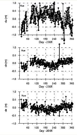
Figure 2.
Daily mean de, dn, du in the Huế station.
As mentioned above, it exists clearly an annual
variation in the time series of the coordinate residuals and of the IWV. In
order to eliminate the short period variations, the monthly means of the coordinates
residuals and of the IWV were computed and presented on the Fig. 6 for the 2005
and Fig. 7 for the 2006. On these figures, each graph represents the time
variation of one of the monthly mean coordinate residuals and of the monthly
mean IWV. We can see that the amplitue of the annual variation of the du is of about ±0.8 m, of the de
and dn is ±0.3 m. The correlation coefficients of the monthly
means are presented in the table 2. Rdu-iwv are of about 0.9, except
for the 2006 in Hồ Chí Minh City Rdu-iwv = 0.29. This is caused by
the fact that the daily mean values of the du
are very big (Fig. 3) from the 15th to the 25th June
2006, so the monthly mean du for the
June is very far from the normal tendency. The  is of 0.8, if the GPS
data in June 2006 at the Hồ Chí Minh City station is not included. The
is of 0.8, if the GPS
data in June 2006 at the Hồ Chí Minh City station is not included. The  are negative and
significant (about -0.6 to -0.9) for the 2006; the Rdn-ivw are
negative also but smaller (about -0.2 to -0.5). So for the monthly means values
the correlation coefficients are larger than for the daily means. This could be
understood by the fact that the coordinate residuals determined by GPS affected
by the local atmospheric conditions, meanwhite the IWV data from the global
model can not include these conditions, so when the data series are averaged
for a longer time interval, then their correlations become better.
are negative and
significant (about -0.6 to -0.9) for the 2006; the Rdn-ivw are
negative also but smaller (about -0.2 to -0.5). So for the monthly means values
the correlation coefficients are larger than for the daily means. This could be
understood by the fact that the coordinate residuals determined by GPS affected
by the local atmospheric conditions, meanwhite the IWV data from the global
model can not include these conditions, so when the data series are averaged
for a longer time interval, then their correlations become better.
Table 1. Correlation between the de,
dn, du local navigation coordinate residuals
and the IWV in Hà Nội, Huế and Hồ Chí Minh City
for the 2005-2006 period
|
Station
|
Year
|
Rde-iwv
|
Rdn-iwv
|
Rdu-iwv
|
|
Hà Nội
|
2005
|
-0.04
|
-0.15
|
0.71
|
|
2006
|
-0.40
|
-0.08
|
0.77
|
|
Huế
|
2006
|
-0.44
|
-0.16
|
0.68
|
|
Hồ Chí Minh City
|
2005
|
-0.03
|
-0.04
|
0.32
|
|
2006
|
-0.37
|
-0.20
|
0.19
|
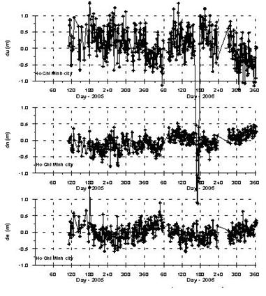
Figure 3. Daily mean de,
dn, du in the Hồ Chí Minh City station.
To find the correlation between short period
variations of the coordinate residuals and of the water vapour, the long period
variations of the daily mean datum series have been approximated by the
polynomials and then excluded. After some tests with the different degree
polynomials, we selected the 15 degree polynomial to approximate the variations
with the periods longer than about 1 month (Fig. 8).
The
short period variations of the coordinates residuals (dde, ddn, ddu), and of the IWV (diwv) are obtained by eliminating the long period
variations approximated by the 15th degree polynomials as mentioned
above. For example, the Fig. 9 represents the time variations of the ddu and of the diwv at Hà Nội station for
the 2005-2006 period. We can see that the curves ddu and diwv represent short period
variations with the wave lengths from some days to some decades and there is a
certain correlation between them. The correlation coefficients between the diwv and the dde, ddn, ddu at three stations Hà
Nội, Huế and Hồ Chí Minh City for the
2005-2006 period are presented in the Table 3. We can see that, the Rddu-diwv are positive,
significant and decrease also from Hà Nội to Hồ Chí Minh City
as the Rdu-iwv, but for three stations they are smaller than the
values correspondent in the Table 2. The Rdde-diwv and Rdn-diwv are small for the
2005-2006 period. As mentioned above, the absolute positioning by GPS is
affected by the local atmospheric conditions (not including non-atmospheric
noises), meanwhile the IWV is computed from the global model, whose local
characteristics are averaged, so the correlations between the diwv and the dde, ddn, ddu cannot be as large as
those between the monthly mean iwv
and de, du, dn.
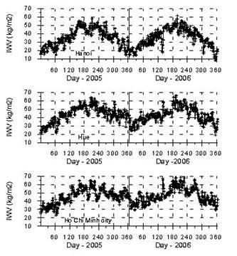
Figure 4. IWV in Hà Nội (top), Huế (middle) and Hồ Chí Minh cities
(bottom).
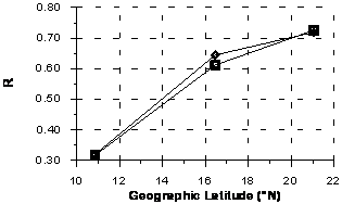
Figure 5. Correlation coefficient Rdu-iwv as a function of
the geographic latitude.
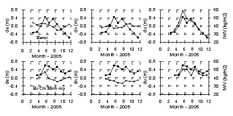
Figure 6. Time variation of monthly means de, dn, du (open
diamonds)
and of the IWV (open squares) for the
2005.
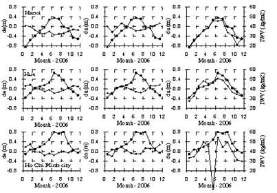
Figure 7. Time variation of monthly means de, dn, du (open
diamonds)
and of the IWV (open squares) for the
2006.
Table 2. Correlation
between the monthly means of the coordinate residuals and of the IWV
|
Station
|
Year
|
Rde-iwv
|
Rdn-iwv
|
Rdu-iwv
|
|
Hà Nội
|
2005
|
-0.09
|
-0.28
|
0.95
|
|
2006
|
-0.87
|
-0.35
|
0.95
|
|
Huế
|
2006
|
-0.92
|
-0.25
|
0.89
|
|
Hồ Chí Minh City
|
2005
|
0.05
|
-0.50
|
0.88
|
|
2006
|
-0.64
|
-0.22
|
0.29
|
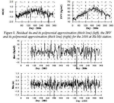
Figure 9. Short period variations
of the IWV diwv (top)
and of the up component residual ddu (bottom) at Hà Nội station.
Table 3. Correlation between
short period variations of the coordinates residuals
and of the
IWV.
|
Station
|
Year
|
Rdde-diwv
|
Rdde-diwv
|
Rddu-diwv
|
|
Hà Nội
|
2005
|
0.01
|
-0.15
|
0.40
|
|
2006
|
-0.03
|
0.04
|
0.58
|
|
Huế
|
2006
|
0.03
|
0.12
|
0.43
|
|
Hồ Chí Minh city
|
2005
|
0.07
|
0.15
|
0.28
|
|
2006
|
-0.05
|
-0.01
|
0.19
|
IV. CONCLUSIONS
The results in this paper show
that the precision of the absolute positioning by the Novatel’s dual-frequency
GPS receivers is of about 1-2 m.
The precision of the absolute
positioning by GPS is dependent clearly on the tropospheric IWV. But the
precision of the determination of different coordinate components depend
differentially on the IWV, the smallest precision in the determination of the
up component (or altitude). In the Việt Nam region, in the dry season, the
humidity is small, the atmospheric
influences on the absolute positioning by GPS are also small. So to increase
the precision of the geodesic measurements by GPS, they would be carried out in
the dry season (on December and on January).
The results in this paper show
also that the precision of the absolute positioning by GPS in the equatorial
and low-latitude regions (from Huế to the South of Việt Nam) is smaller than in
the middle latitudes, so the geodetic measurements by GPS in the South of Việt
Nam are may be paid more attentions to the atmospheric conditions.
Acknowledgments: This paper is realized with the financial support of the Basic
Research project No 7.119.06: “Treatment of data of the three continuous GPS
stations at Hà Nội, Huế and Hồ Chí Minh cities with the main application in the
study of the total electron content of the ionosphere in Việt Nam and of the
crustal movement in the stations”.
REFERENCES
1. Bastin
S., C. Champollion, O. Bock, P. Drobinski, F. Masson, 2005. On the use of GPS tomography to investigate water vapor
variability during a mistral/sea breeze event in southeastern France. Geoph. Res. Lett., 32, L05808,
doi:10.1029/2004GL021907.
2. Champollion C., F. Masson, J. Van Baelen, A. Walpersdorf, J. Chery, E. Doerlinger, 2004. GPS monitoring of the
tropospheric water vapor distribution and variation during the 9 September 2002
torrential precipitation episode in the Cevennes
(South France). J. Geophys. Res., 109, D24102, doi:1029/2004JD004897.
3. Drake S.P., 2002. Converting GPS coordinates (jlh) to navigation coordinates (ENU). DSTO-TN-0432.
4. Duan J. et al., 1996. GPS meteorology: Direct estimation of the absolute value of
precipitable water. J. Appl. Meteor.,
35: 830.
5. Hoftmann-Wellenhof
B., H. Lichtenegger, J. Collins, 2001. GPS theory and
practice. Springer.
6. Kalnay E. et al.,
1996. The NCEP/NCAR 40-year
reanalysis project. Bull. Amer. Meteor.
Soc., 77 : 437-462.
7. Kanamitsu M., W.
Ebislizaki, J. Woollen, S.-K. Yang, J.J. Hnilo, M. Fioring, G.L. Potter, 2002. NCEP-DOE AMIP-II reanalysis (R-2). Bull. Amer. Meteor. Soc., 83:
1631-1642.
8. Lê Huy Minh, A.
Bourdillon, P. Lassudrie-Duchesne, R. Fleury, Nguyễn Chiến Thắng, Trần Thị Lan,
Ngô Văn Quân, Lê Trường Thanh, Trần Ngọc Nam, Hoàng Thái Lan, 2006. Determination of the ionospheric
total electron content in Việt Nam
by using the data from three GPS receivers at Hà Nội, Huế and Hóc Môn. J. Geology, A/296: 54-62. Hà Nội (in Vietnamese).
9. Lê Huy Minh, Nguyễn
Chiến Thắng, Trần Thị Lan, R. Fleury, P. Lassudrie-Duchesne, A. Bourdillon, C.
Amory-Mazaudier, Trần Ngọc Nam, Hoàng Thái Lan, 2007. The
effect of geomagnetic storm on the ionospheric total electron content in the
Southeast Asian equatorial ionization anomaly region observed by the GPS data. J. Sci. of the Earth, 29/2: 104-112. Hà Nội (in Vietnamese).
10. Novatel, 2003. OEM4 family of receivers. USER manual.
11. Vi Quốc Hải, Trần
Đình Tô, Dương Chí Công, 2004. Discussion on the absolute coordinates determinated by GPS in WGS-84. J. Sci. of the Earth, 26/1: 76-81. Hà
Nội (in Vietnamese).