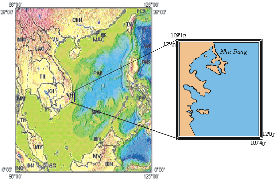
Fig. 1. Location of
the research area and features of the Việt Nam continental shelf
(3D map adapted after USGR)
SEDIMENT DISTRIBUTION PATTERN AND THE ROLE OF MATERIAL SOURCES ON THE INNER
SHELF OFF NHA TRANG
HOÀNG
VĂN
LONG1 , ĐÀM QUANG MINH2
1University of Mining and Geology, Đông
Ngạc, Từ Liêm, Hà Nội
2University of Natural Sciences, Hà Nội National University, Nguyễn
Trãi, Hà Nội
Abstract: The recent sediments on the inner shelf near Nha Trang have a relatively
complicated distribution pattern. The coarser sediments, such as sand and
gravel are observed near shore and in the southeast of the area, while the
finer fractions are mainly distributed in the embayment areas and in the north
of Nha Trang offshore. The major components, grain-size,
roundness, distribution location of the sediments show that this area is characterized
by reworking process of the previous sediments. Material sources
supplying this area are also abundant and diversified, but consist mainly of clastic
materials derived from continent by the channels near Nha Trang and contiguous
areas.
I. INTRODUCTION
The continental shelf of Việt
Confronting the requirements for planning and orienting the proper use of
the sea territories, more detail investigations in some particular areas are
needed.
Based on the data collected during VG5-cruise off Nha
Trang carried out in May 2004, the authors present some characteristics of the recent
sediments on the inner shelf off
- Surface sediment distribution versus grain-sizes,
- Hydrodynamic regimes controlling sediment distribution,
- The role and influence of sediment sources in the recent sedimentation.
I. GENERAL OF THE RESEARCH AREA
The research activities were concentrated on the inner shelf off
The inner shelf off
Fig. 1. Location of
the research area and features of the Việt Nam continental shelf
(3D map adapted after USGR)
III. METHODOLOGY
The studies to determine the aforementioned objectives were carried out
based on the analysis of the recent sediments. Totally, 30 samples collected
within the interest area were used for analysis (Table 1).
The sedimentary samples were prepared and analyzed by 2 methods as follow:
1. Grain-size analysis
In this method, each sample was splitted into 2 fractions: the coarser
fraction has grain-size greater than 63 µm while the finer one has grain-size
smaller than 63 µm.
The coarser fraction was analyzed by small sieves at various size-classes
of 63 - 125 - 250 - 500 - 1000 - 2000 µm. The finer fraction was analyzed by
laser analyzer in order to give a more detailed grain-size distribution,
corresponding to finer size-classes which cannot be done by sieving. However,
samples were stored for a long time in plastic bags, the sticky and very fine
grains tend to be re-flocculated. This problem will probably give rise to
difference from factual values. Therefore, samples were subjected to supersonic
treatment to break flocculations apart prior to analysis.
The data from sieving
and laser analysis was re-combined to give a continuous and more detailed range
of sediment distribution, corresponding to the increase in grain-size from clay
- silt - sand - gravel... Construction of accumulative curves, histograms
representing sediment distribution, statistic calculation of mean, sorting,
sediment type... were carried out with support of Gradistad software.
Table 1. ID
and coordinates of the recent sedimentary samples off Nha Trang
|
Station ID |
Converted longitude |
Converted latitude |
Water depth (m) |
Brief description |
|
VG
5 1-1 |
108.162 |
10.356 |
47.0 |
Brownish
grey, clayish medium-coarse sand, rich in shell fragments and foraminifera |
|
VG
5 9-1 |
107.407 |
10.163 |
31.5 |
Greyish
green sand, relatively abundant in shell fragments |
|
VG
5 10-2 |
107.292 |
10.260 |
23.7 |
Greyish
green fine-medium sand, rich in shell fragments |
|
VG
5 11-1 |
107.284 |
10.242 |
29.2 |
Greyish
green fine-medium sand, rich in sandy shell fragments |
|
VG
5 12-1 |
107.280 |
10.230 |
27.5 |
Greyish
green fine-medium sand, moderate in shell fragments |
|
VG
5 13-1 |
107.277 |
10.225 |
27.4 |
Greyish
green clayish fine sand, little in shell fragments |
|
VG
5 14-1 |
107.275 |
10.218 |
26.3 |
Green
clayish sand, rich in shell fragments |
|
VG
5 15-1 |
107.007 |
10.092 |
21.8 |
Green
clayish sand, moderate in shell fragments |
|
VG
5 16-1 |
107.016 |
10.171 |
18.2 |
Greyish
green clayish very fine sand |
|
VG
5 17-1 |
107.028 |
10.265 |
22.8 |
Brownish
grey clayish sand, rich in shells |
|
VG
5 18-1 |
107.043 |
10.266 |
22.1 |
Green
clayish very fine sand |
|
VG
5 19-1 |
107.232 |
10.274 |
23.8 |
Greyish
green very fine sand, relatively rich shell fragments |
|
VG
5 20-1 |
107.417 |
10.164 |
30.0 |
Green
medium-coarse sand, rich in shell fragments |
|
VG
5 21-1 |
107.542 |
10.185 |
39.2 |
Greyish
green fine-medium sand |
|
VG
5 22-1 |
107.532 |
10.185 |
35.6 |
Green
clayish fine sand, shell fragments |
|
VG
5 23-1 |
107.610 |
10.203 |
38.0 |
Green
clayish sand, shell fragments, plant debris |
|
VG
5 24-1 |
107.673 |
10.257 |
31.7 |
Green clayish
fine-medium sand, very rich in shell fragments |
|
VG
5 25-1 |
107.684 |
10.331 |
25.5 |
Greenish
brown, coarse sand, very rich in shell fragment |
|
VG
5 26-1 |
107.683 |
10.357 |
23.3 |
Greenish
brown, coarse sand, very rich in shell fragment |
|
VG
5 27-1 |
107.675 |
10.465 |
18.4 |
Green
clayish coarse sand, very rich in shells |
|
VG
5 28-1 |
107.978 |
10.567 |
26.4 |
Green
clayish coarse sand, very rich shell |
|
VG
5 29-1 |
108.023 |
10.301 |
? |
Greenish
grey clayish coarse sand, very in rich in shells and moderate in forams |
2. Component analysis
The components of the clasts were examined to determine the role of
sediment sources affecting sedimentation process off Nha Trang and determine
the diversity of sedimentary environments. The previous studies indicated that
the sedimentary components distributed quite evenly in various size-classes [3,
4]. For a convenience, the fraction of 250 – 500 µm microns of each sample was
introduced to examination under microscope for 4 main groups as follows: foraminifera,
lithoclasts, shell fragments, plant debris.
3. Constructing thematic maps
The thematic maps were built to represent the distribution of sediments
and the major relevant components on the sea floor off Nha Trang.
Map of sediment distribution: each sediment type deduced from grain-size analysis
was assigned to a numerical value in increasing order in accordance with the
increase in the percentage of the coarse grains in the sample, so that the
computer programme can recognized and process automatically.
Maps of component distribution: the number of fragments of 4 major groups was
counted under microscope and converted into percentage values.
The numerical and
percentage values coupled with sample coordinates were subjected to
interpolation by Surfer software. During interpolation, some mathematic
conditions were applied to prevent from over-interpolation at the boundary
between land and/or island and water.
III. RESULTS
1. Results of grain-size analysis
The results of grain-size analysis are summarized in Table 2 below.
Table 2. Results of grain-size analysis
for recent sediment samples off Nha Trang
|
Station ID |
Sample type |
Sorting |
Sediment
name |
Mean (µm) |
||||
|
Method of moments |
Folk & Ward Method |
|||||||
|
Arithmetic |
Geometric |
Logarithmic (F) |
Geometric |
Logarithmic (F) |
||||
|
VG5
30-1 |
Unimodal |
Poorly sorted |
Fine silt |
12.39 |
8.004 |
6.965 |
8.238 |
6.924 |
|
VG5
31-1 |
Polymodal |
Very poorly sorted |
Very coarse silty fine sand |
143.5 |
65.41 |
3.934 |
66.14 |
3.918 |
|
VG5
32-1 |
Trimodal |
Very poorly sorted |
Very fine sandy fine silt |
61.26 |
24.11 |
5.374 |
24.86 |
5.330 |
|
VG5
33-1 |
Unimodal |
Poorly sorted |
Fine silt |
12.94 |
8.033 |
6.960 |
8.269 |
6.918 |
|
VG5
34-1 |
Bimodal |
Very poorly sorted |
Fine silty medium sand |
493.4 |
158.0 |
2.662 |
142.2 |
2.814 |
|
VG5
35-1 |
Bimodal |
Very poorly sorted |
Fine silty medium sand |
436.7 |
109.7 |
3.189 |
114.8 |
3.123 |
|
VG5
36-1 |
Bimodal |
Very poorly sorted |
Fine silty medium sand |
479.0 |
179.8 |
2.457 |
151.6 |
2.722 |
|
VG5
37-1 |
Bimodal |
Very poorly sorted |
Fine silty fine sand |
167.2 |
43.22 |
4.532 |
48.51 |
4.366 |
|
VG5
38-1 |
Unimodal |
Poorly sorted |
Fine silt |
11.13 |
6.816 |
7.197 |
6.845 |
7.191 |
|
VG5
39-1 |
Unimodal |
Poorly sorted |
Fine silt |
20.76 |
9.919 |
6.656 |
9.856 |
6.665 |
|
VG5
40-1 |
Trimodal |
Very poorly sorted |
Fine silty very coarse sand |
558.5 |
116.0 |
3.108 |
136.2 |
2.877 |
|
VG5
41-1 |
Trimodal |
Poorly sorted |
Medium sandy fine silt |
50.37 |
12.19 |
6.359 |
10.42 |
6.584 |
|
VG5
42-1 |
Bimodal |
Poorly sorted |
Fine silt |
16.14 |
9.787 |
6.675 |
10.04 |
6.638 |
|
VG5
43-1 |
Unimodal |
Poorly sorted |
Fine silt |
17.11 |
10.16 |
6.621 |
10.41 |
6.586 |
|
VG5
44-1 |
Unimodal |
poorly sorted |
Fine silt |
18.71 |
11.14 |
6.488 |
11.58 |
6.432 |
|
VG5
45-1 |
Bimodal |
poorly sorted |
Fine silt |
20.03 |
11.80 |
6.405 |
12.11 |
6.367 |
|
VG5
46-1 |
Unimodal |
Poorly sorted |
Very fine sandy fine silt |
24.77 |
11.05 |
6.500 |
11.07 |
6.497 |
|
VG5
46-2 |
Bimodal |
Poorly sorted |
Fine silt |
22.60 |
10.21 |
6.613 |
9.965 |
6.649 |
|
VG5
47-1 |
Bimodal |
Poorly sorted |
Very fine sandy fine silt |
25.07 |
11.15 |
6.486 |
10.97 |
6.510 |
|
Trimodal |
Very poorly sorted |
Fine silty very coarse sand |
603.6 |
122.1 |
3.034 |
140.6 |
2.831 |
|
|
VG5
48-2 |
Bimodal |
Poorly
sorted |
Very fine gravelly very coarse
sand |
979.5 |
533.2 |
0.907 |
680.2 |
0.556 |
|
VG5
49-1 |
Unimodal |
Moderately sorted |
Coarse sand |
621.8 |
511.0 |
0.969 |
521.7 |
0.939 |
|
VG5
50-1 |
Trimodal |
Poorly sorted |
Fine silt |
24.46 |
11.98 |
6.383 |
12.29 |
6.346 |
|
VG5
51-1 |
Unimodal |
Poorly sorted |
Fine silt |
10.94 |
7.775 |
7.007 |
8.109 |
6.946 |
|
VG5
52-1 |
Unimodal |
Poorly sorted |
Fine silty medium sand |
308.4 |
200.1 |
2.321 |
259.7 |
1.945 |
|
Bimodal |
Poorly sorted |
Fine silty medium sand |
340.5 |
176.0 |
2.506 |
255.1 |
1.971 |
|
|
VG5
53-2 |
Bimodal |
Very poorly sorted |
Fine silty medium sand |
309.1 |
158.2 |
2.660 |
140.6 |
2.831 |
|
VG5
54-1 |
Bimodal |
poorly sorted |
Fine silt |
23.84 |
9.481 |
6.721 |
8.916 |
6.809 |
|
VG5 55-2 |
Unimodal |
Moderately sorted |
Slightly very fine gravelly medium sand |
337.8 |
251.2 |
1.993 |
267.1 |
1.905 |
|
VG5
57-1 |
Unimodal |
Poorly sorted |
Slightly very fine gravelly fine
silty coarse sand |
904.3 |
437.3 |
1.193 |
666.6 |
0.585 |
|
VG5
58-1 |
Bimodal |
Poorly sorted |
Fine silt |
14.97 |
8.857 |
6.816 |
9.060 |
6.786 |
The data in Table 2
shows that, sediments on the inner shelf near
2. Map of sediment distribution
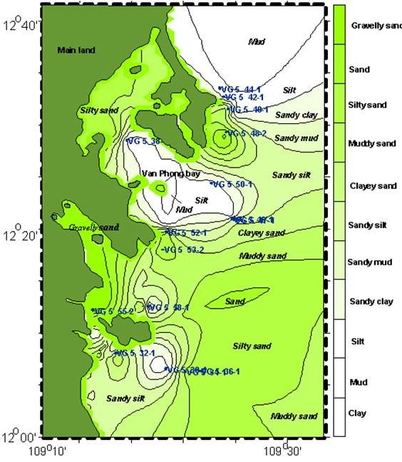
Fig. 2. Sediment distribution off
Fig. 2 presents the
distribution of the sediments off
3. Maps of distribution of major components
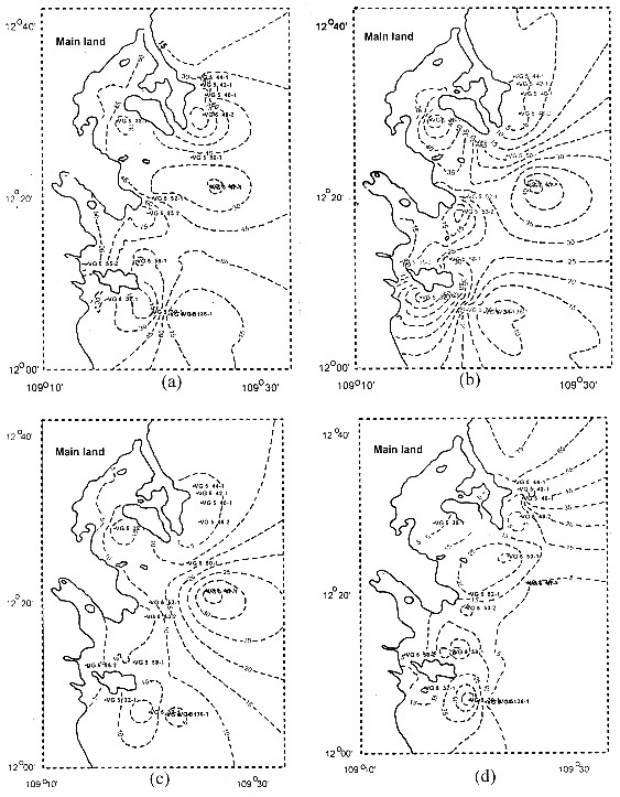
Fig. 3. Maps of distribution of major components
(a)- Percentage of lithoclasts
(b)- Percentage of shell fragments
(c)- Percentage of
foraminifera (d)- Percentage of plant debris
Figure 3 presents the distribution pattern of major components in the
recent sediments off Nha Trang. It clearly shows that, the percentage of
lithoclasts has the highest values nearshore and in the deep-water zone situated
in the southeast of the region. This value gradually decreases towards Văn Phong
Bay, where it is characterized by a high concentration of shell fragments and
foraminifera. The northern part of Nha Trang inner shelf is characterized by a
rapid increase of plant fragments and by a very low content of shell fragments
and foraminifera. Notably, the percentage of plant debris tends to be depleted
towards the southeast.
IV. DISCUSSIONS AND CONCLUSIONS
Based on study results, the inner shelf off Nha Trang can be subdivided
into smaller areas with particular characteristics as follows:
The nearshore zone is characterized by coarse sediments of gravelly sand and
by a high concentration of lithoclasts, which mainly consist of quartz and
granitic fragments. The lithic fragments are mainly derived from weathering
products of geological formations in the adjacent areas, which were transported
to the sea by local channels. Within this zone, terrigenous materials have a
predominant role over other sources. The Văn Phong Bay and adjacent area of some
small islands differ from the nearshore zone. In these areas, sediments are
mainly fine-grained, such as silt, mud. The deposition of fine sediments reveals
a quite calm hydrodynamic regime, which is less influenced by tide and wave. The
percentage of lithoclasts gradually decreases and is replaced by shell
fragments, foraminifera and plant debris. This feature indicated that the marine
sedimentary sources play a notable role in supplying materials to the region. A
quite clear spatial relation between grain-size and component distributions is
displayed on the map: the areas containing fine sediments normally have a low
percentage of lithoclasts, but higher deposition of foraminifera, shell
fragments and plant debris.
The northern part of the interested area has a sudden increase in plant
debris and a quick decrease in lithoclasts, shell fragments and foraminifera.
Probably, the land heads developed from inland have a significant influence on the
protection of the northern part from sea currents. The less influence of sea
currents resulted in a calm condition of the hydrodynamics and deposition of
fine sediments such as mud and clay.
The southeastern part of Nha Trang offshore has a greater depth in
comparison with other parts and is strongly affected by wave, tide and wind coming
from open sea. Due to stronger hydrodynamic regime, sediments in this part
mainly consist of coarse grains with the major component of sub-rounded -
rounded quartz. The maturity and good roundness of quartz particles situated on
the matrix of finer sedimentary materials supported the previous evaluations of
Szcucinski [5], A.Schimanski [3], and A.Schimanski & K.Stattegger [4], that
this area has undergone a reworking process of the sediments deposited in the
glacial periods. This is a by-passing area, over which sediments are
transported to the deep sea by tide and wave.
Due to the lack of stable isotope analysis on plant debris, the question what
the origin of plant debris is? or whether they came
from continent or sea? is not well answered yet. Moreover, the unevenly
designed sampling grid cannot ensure the representative of the samples in some
places. This problem may give rise to error in interpolation for map
construction. In order to solve these problems, additional stable/radioactive
isotope analysis as well as adjusted sampling grid should be done for the
forthcoming investigation cruise.
REFERENCES
1. Hanebuth
T.J.J., Stattgger K., Schimanski A., Ludmann T. & Wong H.K., 2003. Late Pleistocene forced-regressive
deposits on the Sunda Shelf (
2. Hoàng Văn
Long, 2005. Recent sedimentation on the inner shelf between
3. Schimanski A., 2002. Holocene sedimentation on the Việt Namese Shelf:
From source to sink. Christian Universitat zu
4. Schimanski A. & Stattegger K.,
2005. Deglacial and Holocene
evolution of the Việt Nam shelf: Stratigraphy, sediments and sea-level change. Marine Geology, 214 : 365-387.
5. Szcucinski W., 2000. Rate and Style of sedimentation in
offshore region of
6. Szcucinski W. & Stattegger K.,
2001. Style and
rate of shelf sedimentation offshore Nha Trang, Việt