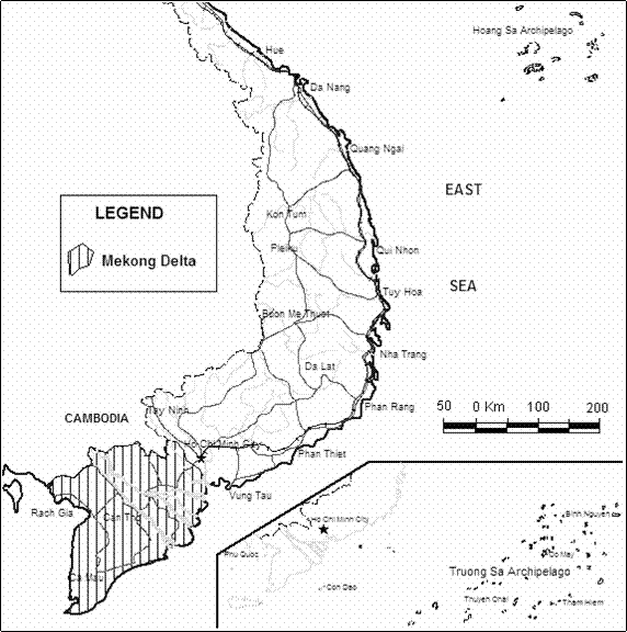
Figure 1. Location of the
TEMPERATURE LOGGING AND GEOTHERMAL DATA
FROM THE
NGUYỄN HỒNG BÀNG
Division
for Hydrogeology and Engineering Geology of
Abstract: The temperature logging in a borehole of the
The main significance of these results can serve different purposes, especially for
geothermal study.
INTRODUCTION
The Mekong Delta is a low plain located in the
southernmost part of Việt
The recording of temperature variations in a borehole
provides with useful information to geothermal researcher, such as informations
on temperature corresponding to depth. The temperature logging in Mekong Delta
has been carried out using temperature sonde connected to poly-resistivity
probe 2PEA-1000 and digital
The temperature
data are used for thermal gradient estimation and identifying temperature
change with the depth of ≤ 250 m and > 250 m in the whole Mekong Delta.
The results show that the thermal gradient K/100 m
varies significantly from one borehole to another with the values of from 0 to
11.9. The temperature contours of the two depth intervals show different
pictures distinguishing the areas with thermal and cool water and direction of
temperature change.
I. PRINCIPLES
In the present hydrological study, the available
instruments consist generally of continuous recording of temperature using a
sensor lowered into the borehole. This type of measurement provides with a lot
of temperature corresponding to the depth.
Modern instruments generally include a thermistor
whose internal electrical resistance varies with changes in temperature. The
sensor is mounted on a tube that allows the fluid to flow past it when the probe
is lowered into the borehole.
A temperature that is representative for the surrounding rock can usually
be measured in the borehole fluid only, as considerable air circulation may
take place above the fluid level in the hole. For this reason one mostly
observes a temperature step with the entry of the probe into the fluid.
Due to the annual temperature wave the natural temperature increases with
depth (geothermal gradient: on average 3oC/100 m) can first be
observed at a depth of about 20-30 m. Deviations from the normal temperature
rise can indicate vertical water movements in the borehole or in the
surrounding rock.
Figure 1. Location of the
II. MEASUREMENT AND INTERPRETATION
1. Measurement: The instruments consist of the MGX II console with
digitally recording and the poly-resistivity probe 2PEA-1000 with connected to
them temperature sonde. The temperature sensor has a certain response time and
hence the speed of logging should be constant and very slow, so that
measurements reflect with precision the temperatures at different depth. On the
other hand, the log is recorded as the instrument is lowered, so that the
temperatures are not altered due to agitation of the fluid when the cable and
probe pass through it. For the same reason, the temperature log should be
programmed before other measurements. Figure 2 illustrates the temperature log
and resistivity, gamma ray logs of borehole “Pataya” in Cần Thơ City located on
the south bank of the
2. Interpretation: When the depth of investigation is limited, the
temperature recorded will be that of the fluid surrounding the sensor and it
should be representative of the temperature of the surrounding rock formations.
In this paper, the temperature recorded data are used for:
- Estimating
the geothermal gradient of the Mekong Delta area
- Identifying the temperature change with depth.
a. Determination of geothermal
gradient
The subsurface temperature increases in a very irregular manner in
relation to depth; on average, it increases by 1oC for every 30 m.
This is known as the geothermal degree. The geothermal degree varies from one
place to another depending on topographic conditions, present rock types and
geological history of the region. During the drilling, the temperature of the
mud remains uniform due to continuous circulation. When drilling operations are
terminated, the mud at rest reaches a temperature equal to that of the thermal
gradient of the site. Hence the temperature increases with depth.
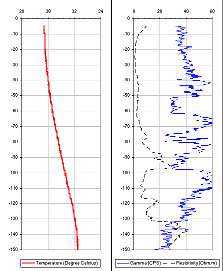
Figure 2. Temperature log at Pataya borehole,
Cần Thơ City
The geothermal gradient is estimated using the temperature log. The
surface temperature of the mud can easily be measured or using annual average
temperature of the Mekong Delta area (28oC). The temperature value
at depth can be taken from the temperature log at the deepest aquifer, then
thermal gradient can be calculated for every borehole. The geothermal gradient
of 210 boreholes in Mekong Delta has been
determined, and the results are presented in the below Fig. 3, showing these
value per 100 m for every borehole.
Two depth intervals of £ 250 m and > 250 m have been selected for
identifying temperature change. Aquifers representative for the depth intervals
can be distinguished by synthesis of different logs. Then, the temperature
value of the aquifers is taken from temperature log. These values of
temperature are those of water in the aquifers and should be also
representative of the temperature of the surrounding rock formations.
Kriging method has been used for contouring the
temperature in Mekong Delta area.
Figure 4 and figure 5 show the shape of temperature contours for two depth
intervals of £ 250 m and > 250 m
respectively.
III. DISCUSSION
The thermal
gradient K/100 m varies from one borehole to another with the values of from 0
to 11.9. This means the temperature change with depth is significant in the
Mekong Delta. Not much boreholes have geothermal gradient value of about 0-1
and they can be explained by getting cold water from river or from hydraulic
window of aquifer. Almost all these boreholes are located near river and their
depth is of < 250 m (Fig. 3).
The contours
for borehole depth of £ 250 m (Fig. 4) show two higher temperature areas in the north, near the
border with
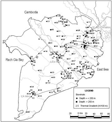
Figure 3. Temperature gradient (K/100 m) in boreholes
in the
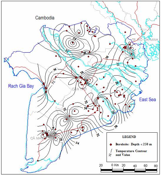
Figure 4. Temperature contour map of the depth
interval of £ 250 m
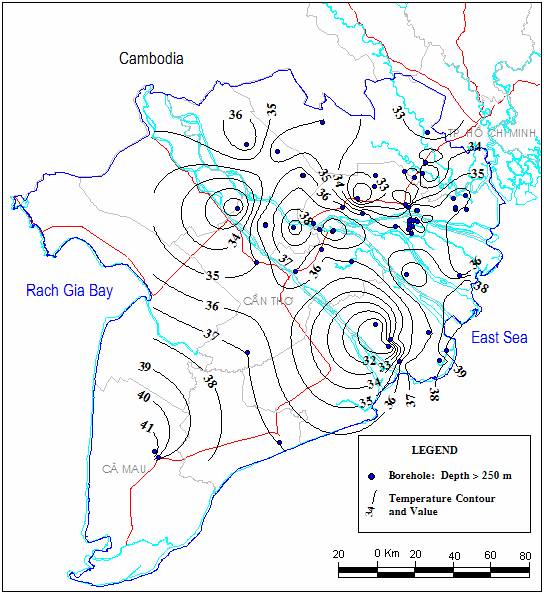
Figure 5. Temperature
contour map of the depth interval of
> 250 m
For the depth
of > 250 m, the contour shows generally that temperature increases from
north to south and southeast with the temperature range from 32 to 42oC
(Fig.5).
IV. CONCLUSIONS
Measurements of temperature are pontentially valuable because it provides
with a lot of temperatures corresponding to the depth and these data can be
interpreted for geothermal purpose.
The geothermal gradient estimated from temperature
log proves significant change of temperature with depth at every borehole
located in the Mekong Delta. The temperature contour shows not only the
temperature change trend in the whole area, but also indicates the areas having
thermal and cool water.
Identified
temperature change with depth and with area and its value have big practical
significance for different purposes, especially for geothermal study.
REFERENCES
1. Chapellier, D., 1968. Well Logging in Hydrogeology. A.A Balkema Publishers,
2. Nguyen Hong Bang, 2001. Present situation of geothermal resources in Việt
3.
Nguyen Hong Bang, 2002.
Geothermal resources in Việt